Chest opened
+${chestReward.xp} XP
Explorer
NOUVEAU ×${chestReward.collectible.quantity}
tapez pour fermer
Chest locked

Open chests in the app

Around Us is built for your phone — chests unlock when you walk, explore and capture nearby places.

Enable Location

We need your location to show you interesting places around you

Discover nearby places

Find interesting locations and hidden gems around you

Precise directions

Get accurate directions and distances to places

Your location is never shared with other users. It's only used when you tap the location button.

Annandale

Log in to your account

Start exploring — it's free

Trusted by 72,878 travelers worldwide

Continue with Google
Continue with Apple
or

We will send you a code to connect

By continuing, you accept our Terms and Conditions and our Privacy Policy

Check your inbox

We've sent a pincode in your inbox. Please enter the code below.

Discussion Reviews 1 Photos
10.5k Popularity

Annandale, Census-designated place in Clinton Township, New Jersey

Annandale is a residential area within Clinton Township in Hunterdon County, New Jersey. The community features houses spread across its streets alongside small local shops and services that serve everyday needs.

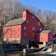
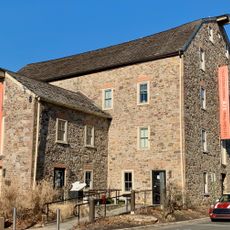
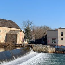
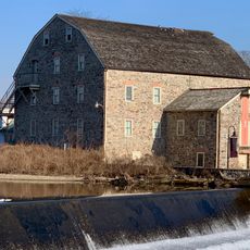
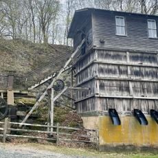
The Annandale Historic District was added to state and national historic registers in 1994. The buildings within it reflect how architecture changed in New Jersey across different periods.

The population of 1,695 residents represents a mix of backgrounds, with 86 percent White, 7 percent Asian, and 4 percent Hispanic or Latino communities.

The area is easily accessible and situated at a slightly elevated location with gentle terrain. It is a small, quiet place where most activities and services can be found nearby or in surrounding towns.

Jones Tavern was once a recruitment station for the Hunterdon County militia during the American Revolution era. The building shows how local establishments played important roles in their communities during that time.

The community of curious travelers

AroundUs brings together thousands of curated places, local tips, and hidden gems, enriched daily by 60,000 contributors worldwide.

Start exploring
Location
Elevation above the sea
129 m
GPS coordinates
40.64222,-74.88444
Latest update
December 10, 2025 15:53
Around this place
United States of America

Round Valley Reservoir

6.1 km
Spruce Run Recreation Area
United States of America

Spruce Run Recreation Area

5.1 km
Red Mill
United States of America

Red Mill

2.5 km
Voorhees State Park
United States of America

Voorhees State Park

6 km
Pennsylvania Railroad 4877
United States of America

Pennsylvania Railroad 4877

4.1 km
Fink-Type Truss Bridge
United States of America

Fink-Type Truss Bridge

4.5 km
Hunterdon Art Museum
United States of America

Hunterdon Art Museum

2.4 km
Ken Lockwood Gorge Bridge
United States of America

Ken Lockwood Gorge Bridge

6.2 km
Clinton Historic District
United States of America

Clinton Historic District

2.2 km
Main Street Bridge
United States of America

Main Street Bridge

2.4 km
Paul Robinson Observatory
United States of America

Paul Robinson Observatory

4.6 km
Dunham's Mill
United States of America

Dunham's Mill

2.4 km
M. C. Mulligan & Sons Quarry
United States of America

M. C. Mulligan & Sons Quarry

2.5 km
Red Mill Museum Village
United States of America

Red Mill Museum Village

2.5 km
Christoffel Vought Farmstead
United States of America

Christoffel Vought Farmstead

1.2 km
Lansdown
United States of America

Lansdown

4.4 km
Old Grandin Library
United States of America

Old Grandin Library

2.2 km
Music Hall
United States of America

Music Hall

2.7 km
Bethlehem United Presbyterian Church
United States of America

Bethlehem United Presbyterian Church

5 km
Union Forge Bridge
United States of America

Union Forge Bridge

3 km
Spruce Run Reservoir
United States of America

Spruce Run Reservoir

4.2 km
Cokesbury United Methodist Church
United States of America

Cokesbury United Methodist Church

6.1 km
Lake Solitude
United States of America

Lake Solitude

3.6 km
Readingsburg Historic District
United States of America

Readingsburg Historic District

4.4 km
Solitude House
United States of America

Solitude House

3.2 km
Cokesbury Historic District
United States of America

Cokesbury Historic District

6 km
Lebanon Historic District
United States of America

Lebanon Historic District

4.2 km
Annandale Historic District
United States of America

Annandale Historic District

334 m
Show the full map
Reviews
Share your experience

No review yet

Discussions
Start a discussion...

No discussion yet

« Annandale - Census-designated place in Clinton Township, New Jersey » is provided by Around Us (aroundus.com). Images and texts are derived from Wikimedia project under a Creative Commons license. You are allowed to copy, distribute, and modify copies of this page, under the conditions set by the license, as long as this note is clearly visible.

Discover hidden gems everywhere you go!

From secret cafés to breathtaking viewpoints, skip the crowded tourist spots and find places that match your style. Our app makes it easy with voice search, smart filtering, route optimization, and insider tips from travelers worldwide. Download now for the complete mobile experience.

Around Us App Screenshot

A unique approach to discovering new places

Le Figaro

All the places worth exploring

France Info

A tailor-made excursion in just a few clicks

20 Minutes

Around Us
Travel Guide & Maps
Download

Send to your phone

QR Code
1

Open the camera app on your mobile.

2

Point at the QR code with your camera. A notification will appear.

3

Tap the notification to open the link.