Enable Location

We need your location to show you interesting places around you

Discover nearby places

Find interesting locations and hidden gems around you

Precise directions

Get accurate directions and distances to places

Your location is never shared with other users. It's only used when you tap the location button.

Bob Michel Bridge

Log in to your account

Start exploring — it's free

Trusted by 61,917 travelers worldwide

Continue with Google
Continue with Apple
or

We will send you a code to connect

By continuing, you accept our Terms and Conditions and our Privacy Policy

Check your inbox

We've sent a pincode in your inbox. Please enter the code below.

Bob Michel Bridge

Bob Michel Bridge, Road bridge in Peoria County, Illinois, US

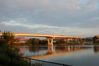
The Bob Michel Bridge is a road bridge in Peoria County, Illinois, that crosses the Illinois River and connects the eastern and western sides of the region. It carries Illinois Route 40 and serves as a major link in the local transportation network.

The structure was completed in 1993 and replaced the older Franklin Street Bridge that had served since 1913. This replacement marked a major modernization of the regional transportation infrastructure.

The bridge is named after Robert H. Michel, a longtime representative from the Peoria area who held significant positions in Congress. His name reflects the importance of this crossing to the local community.

The bridge is accessible to cars, pedestrians, and cyclists, offering passage to multiple forms of traffic across its surface. Visitors should note that the best views of the crossing are possible from the riverbanks or from passing vehicles.

The structure was specifically designed to handle multiple forms of traffic on a single structure, setting it apart from other river crossings in the Peoria area. This multifunctional approach makes it a notable feature of the regional infrastructure.

The community of curious travelers

AroundUs brings together thousands of curated places, local tips, and hidden gems, enriched daily by 60,000 contributors worldwide.

Start exploring
Location
Inception
1993
Official opening
1993
GPS coordinates
40.68450,-89.59190
Latest update
December 13, 2025 11:40
Around this place
Peoria Civic Center
United States of America

Peoria Civic Center

911 m
Peoria Riverfront Museum
United States of America

Peoria Riverfront Museum

571 m
Murray Baker Bridge
United States of America

Murray Baker Bridge

814 m
Madison Theatre
United States of America

Madison Theatre

1.1 km
United States of America

Renaissance Coliseum

2.7 km
Cedar Street Bridge
United States of America

Cedar Street Bridge

1 km
Taft Homes
United States of America

Taft Homes

1.4 km
Scottish Rite Cathedral
United States of America

Scottish Rite Cathedral

1.5 km
Peoria City Hall
United States of America

Peoria City Hall

896 m
Pettingill-Morron House
United States of America

Pettingill-Morron House

2 km
John C. Flanagan House Museum
United States of America

John C. Flanagan House Museum

2.2 km
West Bluff Historic District
United States of America

West Bluff Historic District

2.6 km
John C. Proctor Recreation Center
United States of America

John C. Proctor Recreation Center

2 km
Peoria Federal Building and U.S. Courthouse
United States of America

Peoria Federal Building and U.S. Courthouse

1.2 km
Peoria Cordage Company
United States of America

Peoria Cordage Company

1.1 km
Central National Bank Building
United States of America

Central National Bank Building

814 m
Peace and Harvest
United States of America

Peace and Harvest

920 m
Grand Army of the Republic Memorial Hall
United States of America

Grand Army of the Republic Memorial Hall

1.1 km
YWCA Building
United States of America

YWCA Building

1.2 km
Cumberland Presbyterian Church
United States of America

Cumberland Presbyterian Church

966 m
Lincoln Branch Peoria Public Library
United States of America

Lincoln Branch Peoria Public Library

1.9 km
Downtown Peoria Historic District
United States of America

Downtown Peoria Historic District

928 m
Laura Bradley Park
United States of America

Laura Bradley Park

3.8 km
The Peoria PlayHouse
United States of America

The Peoria PlayHouse

3.7 km
Marquette Apartments
United States of America

Marquette Apartments

1.3 km
North Side Historic District
United States of America

North Side Historic District

2.1 km
Judge Jacob Gale House
United States of America

Judge Jacob Gale House

1.3 km
McClure Branch Library
United States of America

McClure Branch Library

3.7 km
Show the full map
« Bob Michel Bridge - Road bridge in Peoria County, Illinois, US » is provided by Around Us (aroundus.com). Images and texts are derived from Wikimedia project under a Creative Commons license. You are allowed to copy, distribute, and modify copies of this page, under the conditions set by the license, as long as this note is clearly visible.

Discover hidden gems everywhere you go!

From secret cafés to breathtaking viewpoints, skip the crowded tourist spots and find places that match your style. Our app makes it easy with voice search, smart filtering, route optimization, and insider tips from travelers worldwide. Download now for the complete mobile experience.

Around Us App Screenshot

A unique approach to discovering new places

Le Figaro

All the places worth exploring

France Info

A tailor-made excursion in just a few clicks

20 Minutes

Around Us
Travel Guide & Maps
Download

Send to your phone

QR Code
1

Open the camera app on your mobile.

2

Point at the QR code with your camera. A notification will appear.

3

Tap the notification to open the link.