Chest opened
+${chestReward.xp} XP
Explorer
NOUVEAU ×${chestReward.collectible.quantity}
tapez pour fermer
Chest locked

Open chests in the app

Around Us is built for your phone — chests unlock when you walk, explore and capture nearby places.

Enable Location

We need your location to show you interesting places around you

Discover nearby places

Find interesting locations and hidden gems around you

Precise directions

Get accurate directions and distances to places

Your location is never shared with other users. It's only used when you tap the location button.

Log in to your account

Start exploring — it's free

Trusted by 72,942 travelers worldwide

Continue with Google
Continue with Apple
or

We will send you a code to connect

By continuing, you accept our Terms and Conditions and our Privacy Policy

Check your inbox

We've sent a pincode in your inbox. Please enter the code below.

Discussion Reviews Photo
30.7k Popularity

Fort Monmouth, Military research facility in Monmouth County, United States.

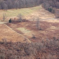
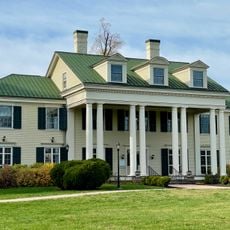
Fort Monmouth is a former military installation spread across extensive grounds in Monmouth County, bordered by several nearby communities. The site sits strategically between geographic landmarks and is currently undergoing redevelopment.

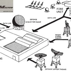
The base was founded in 1919 as a center for US Army signal communications research and quickly became a hub for military technology development. Major breakthroughs in electronics and radio transmission emerged from research conducted there throughout the 20th century.

The first radar technology developed by the US Army in 1938 at Fort Monmouth revolutionized military detection and tracking capabilities.

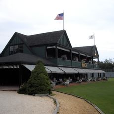
The grounds are open to visitors, though some areas have restricted access and may require permits or prior authorization. It is helpful to check ahead about which sections are freely accessible and where parking is available.

Scientists developed the first radio-controlled weather balloon there in 1928, which changed meteorology forever. This innovation is often overlooked today, yet it made modern weather forecasting possible.

The community of curious travelers

AroundUs brings together thousands of curated places, local tips, and hidden gems, enriched daily by 60,000 contributors worldwide.

Start exploring
Location
GPS coordinates
40.31400,-74.04500
Latest update
December 20, 2025 02:03
Around this place
Shadow Lawn
United States of America

Shadow Lawn

5.1 km
Two River Theater
United States of America

Two River Theater

4.7 km
Church of the Presidents
United States of America

Church of the Presidents

7.3 km
Long Branch Pier
United States of America

Long Branch Pier

5.7 km
Synagogue of Deal
United States of America

Synagogue of Deal

7.8 km
Swimming River Reservoir
United States of America

Swimming River Reservoir

7 km
Parker Homestead
United States of America

Parker Homestead

3.4 km
Murry Guggenheim House
United States of America

Murry Guggenheim House

5 km
Poricy Park
United States of America

Poricy Park

8.6 km
Seabright Lawn Tennis and Cricket Club
United States of America

Seabright Lawn Tennis and Cricket Club

7.8 km
Highlands Army Air Defense Site
United States of America

Highlands Army Air Defense Site

9.6 km
T. Thomas Fortune House
United States of America

T. Thomas Fortune House

3.9 km
Allen House
United States of America

Allen House

1.8 km
Old Mill at Tinton Falls
United States of America

Old Mill at Tinton Falls

4.9 km
Fisk Chapel
United States of America

Fisk Chapel

5.2 km
St. George's-by-the-River Episcopal Church
United States of America

St. George's-by-the-River Episcopal Church

7.9 km
Christ Church , Shrewsbury
United States of America

Christ Church , Shrewsbury

1.7 km
Holmdel Arboretum
United States of America

Holmdel Arboretum

8.4 km
Lauren K. Woods Theatre
United States of America

Lauren K. Woods Theatre

5.2 km
Wardell House
United States of America

Wardell House

1.8 km
St. James Memorial Church of Eatontown
United States of America

St. James Memorial Church of Eatontown

1.4 km
First Presbyterian Church of Rumson
United States of America

First Presbyterian Church of Rumson

7.5 km
North Long Branch School-Primary No. 3
United States of America

North Long Branch School-Primary No. 3

5.7 km
Union Schoolhouse
United States of America

Union Schoolhouse

8.6 km
Thompson Park
United States of America

Thompson Park

9.1 km
Count Basie Theatre
United States of America

Count Basie Theatre

4.4 km
Tinton Falls
United States of America

Tinton Falls

4.8 km
Victory Park
United States of America

Victory Park

7.5 km
Show the full map
Reviews
Share your experience

No review yet

Discussions
Start a discussion...

No discussion yet

« Fort Monmouth - Military research facility in Monmouth County, United States » is provided by Around Us (aroundus.com). Images and texts are derived from Wikimedia project under a Creative Commons license. You are allowed to copy, distribute, and modify copies of this page, under the conditions set by the license, as long as this note is clearly visible.

Discover hidden gems everywhere you go!

From secret cafés to breathtaking viewpoints, skip the crowded tourist spots and find places that match your style. Our app makes it easy with voice search, smart filtering, route optimization, and insider tips from travelers worldwide. Download now for the complete mobile experience.

Around Us App Screenshot

A unique approach to discovering new places

Le Figaro

All the places worth exploring

France Info

A tailor-made excursion in just a few clicks

20 Minutes

Around Us
Travel Guide & Maps
Download

Send to your phone

QR Code
1

Open the camera app on your mobile.

2

Point at the QR code with your camera. A notification will appear.

3

Tap the notification to open the link.