Enable Location

We need your location to show you interesting places around you

Discover nearby places

Find interesting locations and hidden gems around you

Precise directions

Get accurate directions and distances to places

Your location is never shared with other users. It's only used when you tap the location button.

Highlands Army Air Defense Site

Log in to your account

Start exploring — it's free

Trusted by 63,118 travelers worldwide

Continue with Google
Continue with Apple
or

We will send you a code to connect

By continuing, you accept our Terms and Conditions and our Privacy Policy

Check your inbox

We've sent a pincode in your inbox. Please enter the code below.

Highlands Army Air Defense Site
Discussion Reviews 1 Photos
2.3k Popularity

Highlands Army Air Defense Site, Military radar installation in Middletown Township, United States.

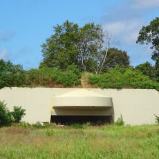
The Highlands Army Air Defense Site was a military installation with multiple radar systems designed to detect and track aircraft in the Middletown Township area. The facility featured underground bunkers and towers that formed an extensive surveillance network.

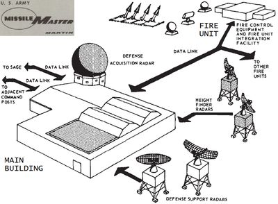
The installation was built in 1958 as part of the broader Nike missile defense network protecting the northeastern United States. It served as a central tracking facility during the height of Cold War aviation surveillance efforts.

The site coordinated tracking operations that were visible through the prominent radar towers rising from the landscape. For residents nearby, it represented Cold War security measures that shaped the local environment.

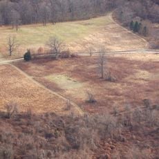
Access to the site is restricted since it remains under military control and protection. Visitors interested in Cold War history should inquire about any public access programs or guided tours offered by local historical organizations.

The facility pioneered the use of an advanced command coordination system that linked multiple defense sites together for the first time. This technology allowed operators to manage air defense across an entire region from a single location.

The community of curious travelers

AroundUs brings together thousands of curated places, local tips, and hidden gems, enriched daily by 60,000 contributors worldwide.

Start exploring
Location
GPS coordinates
40.39460,-74.08530
Latest update
December 13, 2025 12:23
Around this place
Navesink Twin Lights
United States of America

Navesink Twin Lights

8.4 km
Henry Hudson Trail
United States of America

Henry Hudson Trail

4.4 km
Two River Theater
United States of America

Two River Theater

5.1 km
Highlands Air Force Station
United States of America

Highlands Air Force Station

7.8 km
Hartshorne Woods Park
United States of America

Hartshorne Woods Park

8.4 km
Seabrook-Wilson House
United States of America

Seabrook-Wilson House

5 km
Deep Cut Gardens
United States of America

Deep Cut Gardens

3.5 km
Parker Homestead
United States of America

Parker Homestead

6.2 km
Poricy Park
United States of America

Poricy Park

3.8 km
Water Witch Club Casino
United States of America

Water Witch Club Casino

7.8 km
T. Thomas Fortune House
United States of America

T. Thomas Fortune House

6 km
Allen House
United States of America

Allen House

8.1 km
Fisk Chapel
United States of America

Fisk Chapel

5.3 km
Conover Beacon
United States of America

Conover Beacon

3.9 km
Christ Church
United States of America

Christ Church

2.8 km
Christ Church , Shrewsbury
United States of America

Christ Church , Shrewsbury

8.2 km
Water Witch Club Historic District
United States of America

Water Witch Club Historic District

7.5 km
Wardell House
United States of America

Wardell House

8.2 km
First Presbyterian Church of Rumson
United States of America

First Presbyterian Church of Rumson

6.7 km
Keansburg Firemen's Memorial Park
United States of America

Keansburg Firemen's Memorial Park

7.5 km
Union Schoolhouse
United States of America

Union Schoolhouse

4.4 km
Thompson Park
United States of America

Thompson Park

8.3 km
Count Basie Theatre
United States of America

Count Basie Theatre

5.2 km
Navesink south lighthouse
United States of America

Navesink south lighthouse

8.4 km
Navesink north lighthouse
United States of America

Navesink north lighthouse

8.4 km
Victory Park
United States of America

Victory Park

6.5 km
Middletown World Trade Center Memorial Gardens
United States of America

Middletown World Trade Center Memorial Gardens

2.7 km
Brookdale Farm Historic District
United States of America

Brookdale Farm Historic District

8.4 km
Show the full map
Reviews
Share your experience

No review yet

Discussions
Start a discussion...

No discussion yet

« Highlands Army Air Defense Site - Military radar installation in Middletown Township, United States » is provided by Around Us (aroundus.com). Images and texts are derived from Wikimedia project under a Creative Commons license. You are allowed to copy, distribute, and modify copies of this page, under the conditions set by the license, as long as this note is clearly visible.

Discover hidden gems everywhere you go!

From secret cafés to breathtaking viewpoints, skip the crowded tourist spots and find places that match your style. Our app makes it easy with voice search, smart filtering, route optimization, and insider tips from travelers worldwide. Download now for the complete mobile experience.

Around Us App Screenshot

A unique approach to discovering new places

Le Figaro

All the places worth exploring

France Info

A tailor-made excursion in just a few clicks

20 Minutes

Around Us
Travel Guide & Maps
Download

Send to your phone

QR Code
1

Open the camera app on your mobile.

2

Point at the QR code with your camera. A notification will appear.

3

Tap the notification to open the link.