Enable Location

We need your location to show you interesting places around you

Discover nearby places

Find interesting locations and hidden gems around you

Precise directions

Get accurate directions and distances to places

Your location is never shared with other users. It's only used when you tap the location button.

Fort Point Light

Log in to your account

Start exploring — it's free

Trusted by 61,956 travelers worldwide

Continue with Google
Continue with Apple
or

We will send you a code to connect

By continuing, you accept our Terms and Conditions and our Privacy Policy

Check your inbox

We've sent a pincode in your inbox. Please enter the code below.

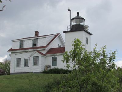
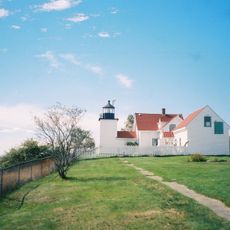
Fort Point Light, Coastal lighthouse in Stockton Springs, Maine.

Fort Point Light is a coastal lighthouse in Stockton Springs consisting of a square brick tower with attached keeper's residence and support buildings. The tower stands 9.5 meters tall and contains one of Maine's eight remaining operational fourth-order Fresnel lenses that continue to function today.

The lighthouse was built in 1836 by the United States Army Corps of Engineers to help guide the growing maritime traffic in Penobscot Bay. It was listed on the National Register of Historic Places in 1988, recognizing its importance to the region's seafaring history.

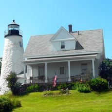
The light marks a focal point in the region's seafaring story and represents how communities depended on such structures for safe passage. Walking around it, you can sense the connection between this beacon and the generations of mariners who relied on its guidance.

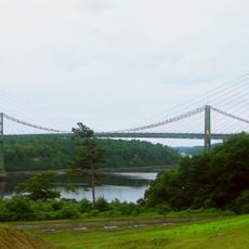
The site is part of Fort Point State Park, where visitors can explore the grounds and enjoy views of the surrounding coastline. The best time to visit is during warmer months when the paths and exterior areas are most accessible.

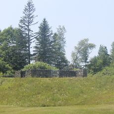
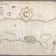
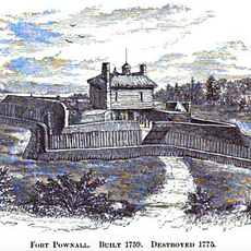
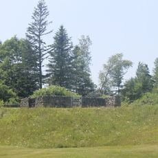
The grounds contain preserved remnants of Fort Pownall dating to 1757, an earlier military fortification now nestled within the park's 120-acre expanse. This layered history shows how this coastal location transformed from a defensive outpost to a navigation aid.

The community of curious travelers

AroundUs brings together thousands of curated places, local tips, and hidden gems, enriched daily by 60,000 contributors worldwide.

Start exploring
Location
Inception
1836
Architects
United States Army Corps of Engineers
Height
9.5 m
GPS coordinates
44.46720,-68.81168
Latest update
December 12, 2025 17:46
Around this place
Fort Knox
United States of America

Fort Knox

11 km
Penobscot Narrows Bridge and Observatory
United States of America

Penobscot Narrows Bridge and Observatory

10.2 km
Bowdoin
United States of America

Bowdoin

9 km
Fort George
United States of America

Fort George

8.5 km
Waldo–Hancock Bridge
United States of America

Waldo–Hancock Bridge

10.4 km
Fort Pentagouet
United States of America

Fort Pentagouet

8.9 km
United States of America

Moose Point State Park

11.3 km
Fort Point State Park
United States of America

Fort Point State Park

577 m
Fort Pownall Memorial
United States of America

Fort Pownall Memorial

103 m
Dice Head Light
United States of America

Dice Head Light

9.4 km
Penobscot Marine Museum
United States of America

Penobscot Marine Museum

9 km
Pentagoet Archeological District
United States of America

Pentagoet Archeological District

9.2 km
Wilson Museum
United States of America

Wilson Museum

9.3 km
United States of America

West Brooksville Congregational Church

9.1 km
Stockton Springs Community Church
United States of America

Stockton Springs Community Church

4.5 km
John Perkins House
United States of America

John Perkins House

9.3 km
Cate House
United States of America

Cate House

8.8 km
Capt. William McGilvery House
United States of America

Capt. William McGilvery House

8.2 km
Capt. John McGilvery House
United States of America

Capt. John McGilvery House

8.4 km
Castine Historic District
United States of America

Castine Historic District

8.5 km
Searsport Historic District
United States of America

Searsport Historic District

9.1 km
Nathan G. Hichborn House
United States of America

Nathan G. Hichborn House

4.5 km
Buck Memorial Library
United States of America

Buck Memorial Library

11.7 km
James G. Pendleton House
United States of America

James G. Pendleton House

9.8 km
Capt. John P. Nichols House
United States of America

Capt. John P. Nichols House

8.3 km
East Main Street Historic District
United States of America

East Main Street Historic District

8.3 km
Carver Memorial Library
United States of America

Carver Memorial Library

8.9 km
Union Hall
United States of America

Union Hall

9 km
Show the full map
« Fort Point Light - Coastal lighthouse in Stockton Springs, Maine » is provided by Around Us (aroundus.com). Images and texts are derived from Wikimedia project under a Creative Commons license. You are allowed to copy, distribute, and modify copies of this page, under the conditions set by the license, as long as this note is clearly visible.

Discover hidden gems everywhere you go!

From secret cafés to breathtaking viewpoints, skip the crowded tourist spots and find places that match your style. Our app makes it easy with voice search, smart filtering, route optimization, and insider tips from travelers worldwide. Download now for the complete mobile experience.

Around Us App Screenshot

A unique approach to discovering new places

Le Figaro

All the places worth exploring

France Info

A tailor-made excursion in just a few clicks

20 Minutes

Around Us
Travel Guide & Maps
Download

Send to your phone

QR Code
1

Open the camera app on your mobile.

2

Point at the QR code with your camera. A notification will appear.

3

Tap the notification to open the link.