Enable Location

We need your location to show you interesting places around you

Discover nearby places

Find interesting locations and hidden gems around you

Precise directions

Get accurate directions and distances to places

Your location is never shared with other users. It's only used when you tap the location button.

Fort Pownall Memorial

Log in to your account

Start exploring — it's free

Trusted by 61,653 travelers worldwide

Continue with Google
Continue with Apple
or

We will send you a code to connect

By continuing, you accept our Terms and Conditions and our Privacy Policy

Check your inbox

We've sent a pincode in your inbox. Please enter the code below.

Fort Pownall Memorial, Colonial fort memorial in Stockton Springs, Maine.

Description

Fort Pownall Memorial sits at the mouth of the Penobscot River with visible foundations and earthen walls from an 18th-century British military installation. The grounds feature informational displays that explain how the fort was built and what role it played in controlling this strategic waterway.

History

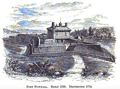
The British military built this fort in 1760 to secure the Penobscot River region during the conflict between French and British colonial powers. The installation served as a defensive post that protected settlements and trade routes in the area.

Culture

The site reveals how this river location shaped military strategy and settlement patterns in early colonial times. The remnants show how soldiers and local communities adapted to life at this frontier outpost.

Practical

The memorial grounds are open year-round for visitors to explore the ruins and walk the site at their own pace. Information boards positioned throughout help explain what you are seeing, so allow time to read them as you move through the grounds.

Did you know?

Archaeological excavations have uncovered personal items and everyday objects left by British soldiers stationed at this remote location. These finds provide a direct window into how soldiers actually lived during their time at this river outpost.

Location
Inception
1760
GPS coordinates
44.46812,-68.81187
Latest update
December 13, 2025 17:03

AroundUs brings together thousands of curated places, local tips, and hidden gems, enriched daily by 60,000 contributors worldwide. Discover all places nearby (Maine).

Around this place
Fort Knox
United States of America

Fort Knox

10.9 km
Penobscot Narrows Bridge and Observatory
United States of America

Penobscot Narrows Bridge and Observatory

10.1 km
Bowdoin
United States of America

Bowdoin

9.1 km
Fort George
United States of America

Fort George

8.6 km
Waldo–Hancock Bridge
United States of America

Waldo–Hancock Bridge

10.3 km
Fort Pentagouet
United States of America

Fort Pentagouet

9 km
United States of America

Moose Point State Park

11.3 km
Fort Point Light
United States of America

Fort Point Light

103 m
Fort Point State Park
United States of America

Fort Point State Park

581 m
Dice Head Light
United States of America

Dice Head Light

9.5 km
Penobscot Marine Museum
United States of America

Penobscot Marine Museum

9 km
Pentagoet Archeological District
United States of America

Pentagoet Archeological District

9.3 km
Wilson Museum
United States of America

Wilson Museum

9.4 km
United States of America

West Brooksville Congregational Church

9.2 km
Stockton Springs Community Church
United States of America

Stockton Springs Community Church

4.5 km
John Perkins House
United States of America

John Perkins House

9.4 km
Cate House
United States of America

Cate House

8.9 km
Capt. William McGilvery House
United States of America

Capt. William McGilvery House

8.2 km
Capt. John McGilvery House
United States of America

Capt. John McGilvery House

8.4 km
Castine Historic District
United States of America

Castine Historic District

8.6 km
Searsport Historic District
United States of America

Searsport Historic District

9.1 km
Nathan G. Hichborn House
United States of America

Nathan G. Hichborn House

4.4 km
East Main Street Historic District
United States of America

East Main Street Historic District

8.3 km
Capt. John P. Nichols House
United States of America

Capt. John P. Nichols House

8.3 km
James G. Pendleton House
United States of America

James G. Pendleton House

9.8 km
Carver Memorial Library
United States of America

Carver Memorial Library

8.9 km
Union Hall
United States of America

Union Hall

9 km
Phineas Heywood House
United States of America

Phineas Heywood House

11.6 km
Show the full map
« Fort Pownall Memorial - Colonial fort memorial in Stockton Springs, Maine » is provided by Around Us (aroundus.com). Images and texts are derived from Wikimedia project under a Creative Commons license. You are allowed to copy, distribute, and modify copies of this page, under the conditions set by the license, as long as this note is clearly visible.

Discover hidden gems everywhere you go!

From secret cafés to breathtaking viewpoints, skip the crowded tourist spots and find places that match your style. Our app makes it easy with voice search, smart filtering, route optimization, and insider tips from travelers worldwide. Download now for the complete mobile experience.

Around Us App Screenshot

A unique approach to discovering new places

Le Figaro

All the places worth exploring

France Info

A tailor-made excursion in just a few clicks

20 Minutes

Around Us
Travel Guide & Maps
Download

Send to your phone

QR Code
1

Open the camera app on your mobile.

2

Point at the QR code with your camera. A notification will appear.

3

Tap the notification to open the link.