Pentagoet Archeological District

Log in to your account

AroundUs is a community-driven map of interesting places, built by curious explorers like you. It grows with every review, story, and photo you share.
Connect to save your favorite spots, contribute locations, and create personalized routes.
Continue with Google
Continue with Apple
Continue with X
Continue with Facebook
Continue with email
By continuing, you accept our Terms and Conditions and our Privacy Policy
Create an account
Add to collection
Map
Suggest a change
Share

Pentagoet Archeological District, Archaeological site and National Historic Landmark in Castine, United States.

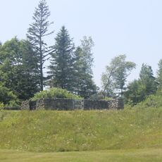
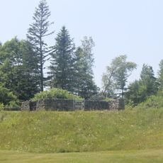
Pentagoet Archaeological District sits at the southern edge of the Bagaduce Peninsula and preserves the remains of a fortified trading post established by French colonists. Excavations have revealed the foundation layouts of storage buildings, barracks, and residential structures that show how the settlement was organized and used.

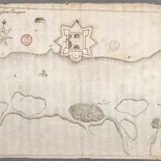
French colonists established this trading post around 1635 and operated it until English forces took control in 1654, shifting colonial power in the region. This transition marked a turning point in the competition between European powers for control of this strategic location.

The trading post served as a meeting place where Abenaki communities exchanged animal hides for European goods, creating a space where different peoples regularly encountered one another. You can sense this cross-cultural exchange reflected in the artifacts scattered across the site.

The site can be walked and explored on your own, with marked foundations and excavated areas showing different parts of the original settlement. Wear comfortable shoes since the ground is uneven in places, and information boards are positioned throughout to help you understand what you are seeing.

The artifacts uncovered here reveal a complex web of connections between French, English, Dutch, and Native American peoples, with each group leaving traces in the form of pottery, tools, and ammunition. Soldiers, traders, and indigenous residents lived on the same ground while competing for power and profit.

Location: Castine

GPS coordinates: 44.38461,-68.80327

Latest update: December 14, 2025 18:13

Photos
Around this place
Deer Isle Bridge
United States of America

Deer Isle Bridge

13.6 km
Bowdoin
United States of America

Bowdoin

573 m
Fort George
United States of America

Fort George

736 m
Fort Pentagouet
United States of America

Fort Pentagouet

452 m
United States of America

Moose Point State Park

13 km
Fort Point Light
United States of America

Fort Point Light

9.2 km
Fort Point State Park
United States of America

Fort Point State Park

9.2 km
Holbrook Island Sanctuary State Park
United States of America

Holbrook Island Sanctuary State Park

3.3 km
Fort Pownall Memorial
United States of America

Fort Pownall Memorial

9.3 km
Dice Head Light
United States of America

Dice Head Light

1.3 km
Pumpkin Island Light
United States of America

Pumpkin Island Light

9.7 km
Penobscot Marine Museum
United States of America

Penobscot Marine Museum

12.8 km
Winter Harbor Light
United States of America

Winter Harbor Light

9.7 km
Wilson Museum
United States of America

Wilson Museum

234 m
United States of America

West Brooksville Congregational Church

3.8 km
Stockton Springs Community Church
United States of America

Stockton Springs Community Church

12.6 km
John Perkins House
United States of America

John Perkins House

240 m
Cate House
United States of America

Cate House

474 m
Capt. William McGilvery House
United States of America

Capt. William McGilvery House

12.1 km
Capt. John McGilvery House
United States of America

Capt. John McGilvery House

12.2 km
Castine Historic District
United States of America

Castine Historic District

708 m
Searsport Historic District
United States of America

Searsport Historic District

12.7 km
Nathan G. Hichborn House
United States of America

Nathan G. Hichborn House

12.5 km
East Main Street Historic District
United States of America

East Main Street Historic District

12 km
Capt. John P. Nichols House
United States of America

Capt. John P. Nichols House

12.1 km
James G. Pendleton House
United States of America

James G. Pendleton House

12.8 km
Carver Memorial Library
United States of America

Carver Memorial Library

12.7 km
Union Hall
United States of America

Union Hall

12.7 km
Show the full map
Reviews

Visited this place? Tap the stars to rate it and share your experience / photos with the community! Try now! You can cancel it anytime.

« Pentagoet Archeological District - Archaeological site and National Historic Landmark in Castine, United States » is provided by Around Us (aroundus.com). Images and texts are derived from Wikimedia project under a Creative Commons license. You are allowed to copy, distribute, and modify copies of this page, under the conditions set by the license, as long as this note is clearly visible.

Discover hidden gems everywhere you go!

From secret cafés to breathtaking viewpoints, skip the crowded tourist spots and find places that match your style. Our app makes it easy with voice search, smart filtering, route optimization, and insider tips from travelers worldwide. Download now for the complete mobile experience.

Around Us App Screenshot

A unique approach to discovering new places

Le Figaro

All the places worth exploring

France Info

A tailor-made excursion in just a few clicks

20 Minutes