Chest opened
+${chestReward.xp} XP
Explorer
NOUVEAU ×${chestReward.collectible.quantity}
tapez pour fermer
Chest locked

Open chests in the app

Around Us is built for your phone — chests unlock when you walk, explore and capture nearby places.

Enable Location

We need your location to show you interesting places around you

Discover nearby places

Find interesting locations and hidden gems around you

Precise directions

Get accurate directions and distances to places

Your location is never shared with other users. It's only used when you tap the location button.

Log in to your account

Start exploring — it's free

Trusted by 72,987 travelers worldwide

Continue with Google
Continue with Apple
or

We will send you a code to connect

By continuing, you accept our Terms and Conditions and our Privacy Policy

Check your inbox

We've sent a pincode in your inbox. Please enter the code below.

Discussion Reviews Photo
22.6k Popularity

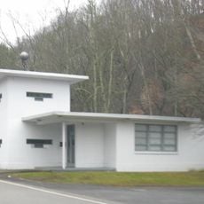
Frozen Head State Park, State park in Morgan County, Tennessee

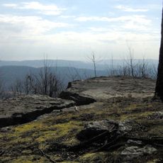
Frozen Head State Park is a nature reserve in Morgan County, Tennessee, covering more than 24,000 acres in the Crab Orchard Mountains. The terrain rises from wooded valleys to rocky high elevations, with more than a dozen summits above 3,000 feet (914 meters).

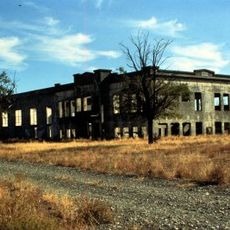
The area served as Cherokee hunting grounds until 1805, when the Third Treaty of Tellico transferred it to the United States. Coal mining and logging shaped the land during the early 1900s, until Tennessee began converting it into a park in stages from the 1970s onward.

The park takes its name from a 3,324-foot (1,013-meter) ridge that remains snowcapped in winter while the surrounding valleys stay green. Hikers encounter old mine shafts and traces of tipples along some of the longer trails, woven into the current route system.

More than 80 miles of marked hiking trails wind through the park, ranging from short woodland paths to full-day climbs to the highest peaks. Campgrounds and designated mountain biking areas offer additional ways to spend several days exploring the terrain.

Every year the park hosts the Barkley Marathons, an ultramarathon through trackless terrain where only twenty runners have finished since 1986. The route passes through dense undergrowth and steep slopes not marked on any map, and the exact rules are revealed only shortly before the start.

The community of curious travelers

AroundUs brings together thousands of curated places, local tips, and hidden gems, enriched daily by 60,000 contributors worldwide.

Start exploring
Location
GPS coordinates
36.12640,-84.50140
Latest update
December 20, 2025 15:55
Around this place
Manhattan Project National Historical Park
United States of America

Manhattan Project National Historical Park

23.4 km
United States of America

Spallation Neutron Source

26.5 km
American Museum of Science and Energy
United States of America

American Museum of Science and Energy

25.7 km
United Church, The Chapel on the Hill
United States of America

United Church, The Chapel on the Hill

25.6 km
George Jones Memorial Baptist Church
United States of America

George Jones Memorial Baptist Church

23.8 km
American Temperance University
United States of America

American Temperance University

21.9 km
Alexander Inn
United States of America

Alexander Inn

25.7 km
Children's Museum of Oak Ridge
United States of America

Children's Museum of Oak Ridge

23.6 km
Cornstalk Heights
United States of America

Cornstalk Heights

21.8 km
Barton Chapel
United States of America

Barton Chapel

26.3 km
New Bethel Baptist Church
United States of America

New Bethel Baptist Church

27.8 km
Roane County Courthouse
United States of America

Roane County Courthouse

28.4 km
Oak Ridge Historic District
United States of America

Oak Ridge Historic District

24.9 km
Luther Brannon House
United States of America

Luther Brannon House

27.8 km
Colonial Hall
United States of America

Colonial Hall

17.1 km
Col. Gideon Morgan House
United States of America

Col. Gideon Morgan House

28.3 km
Lone Mountain State Forest
United States of America

Lone Mountain State Forest

7.5 km
Obed Wild and Scenic River Visitor Center
United States of America

Obed Wild and Scenic River Visitor Center

9 km
Cross Mountain Miners' Circle
United States of America

Cross Mountain Miners' Circle

28.3 km
Oak Ridge Turnpike Checking Station
United States of America

Oak Ridge Turnpike Checking Station

22.2 km
United States of America

Lilly Bluff Overlook

19.7 km
Bear Creek Road Checking Station
United States of America

Bear Creek Road Checking Station

27.2 km
Dr. Fred Stone, Sr., Hospital
United States of America

Dr. Fred Stone, Sr., Hospital

16.9 km
United States of America

Train Cars

23.6 km
United States of America

Abandoned Train

10.9 km
United States of America

Brimstone ATV

20.7 km
United States of America

Work of art

21.8 km
United States of America

Work of art

28.4 km
Show the full map
Reviews
Share your experience

No review yet

Discussions
Start a discussion...

No discussion yet

« Frozen Head State Park - State park in Morgan County, Tennessee » is provided by Around Us (aroundus.com). Images and texts are derived from Wikimedia project under a Creative Commons license. You are allowed to copy, distribute, and modify copies of this page, under the conditions set by the license, as long as this note is clearly visible.

Discover hidden gems everywhere you go!

From secret cafés to breathtaking viewpoints, skip the crowded tourist spots and find places that match your style. Our app makes it easy with voice search, smart filtering, route optimization, and insider tips from travelers worldwide. Download now for the complete mobile experience.

Around Us App Screenshot

A unique approach to discovering new places

Le Figaro

All the places worth exploring

France Info

A tailor-made excursion in just a few clicks

20 Minutes

Around Us
Travel Guide & Maps
Download

Send to your phone

QR Code
1

Open the camera app on your mobile.

2

Point at the QR code with your camera. A notification will appear.

3

Tap the notification to open the link.