Enable Location

We need your location to show you interesting places around you

Discover nearby places

Find interesting locations and hidden gems around you

Precise directions

Get accurate directions and distances to places

Your location is never shared with other users. It's only used when you tap the location button.

American Temperance University

Log in to your account

Start exploring — it's free

Trusted by 62,774 travelers worldwide

Continue with Google
Continue with Apple
or

We will send you a code to connect

By continuing, you accept our Terms and Conditions and our Privacy Policy

Check your inbox

We've sent a pincode in your inbox. Please enter the code below.

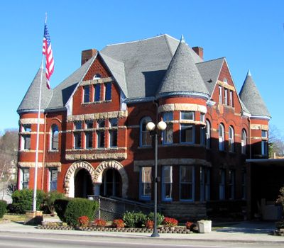
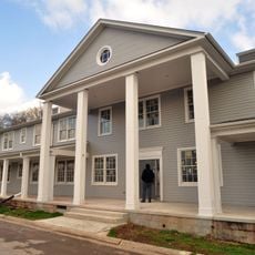
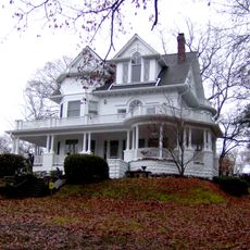
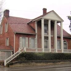
American Temperance University, University building in Cornstalk Heights, Harriman, US.

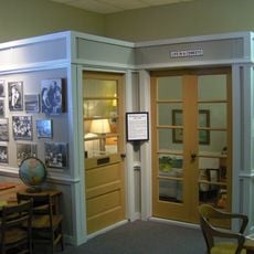
Temperance Hall, the main structure, displays architectural features typical of late 19th-century educational buildings in Tennessee. Today it serves as the municipal office building for the city of Harriman.

The institution was founded in 1890 as a center for education and the temperance cause. It permanently closed in 1908 as national support for the movement declined.

The building was part of a movement that linked education with opposition to alcohol consumption during a reform era. Visitors can still sense how this cause shaped the purpose and character of the place.

The building is accessible from outside as it now houses city government offices and is easy to view from the street. Keep in mind it is an active municipal building, so interior access may be limited.

Two former students went on to become members of the United States House of Representatives, showing how influential its graduates became. John Jennings Jr. and James Willis Taylor exemplify the quality of education provided there.

The community of curious travelers

AroundUs brings together thousands of curated places, local tips, and hidden gems, enriched daily by 60,000 contributors worldwide.

Start exploring
Location
Inception
1890
Part of
Cornstalk Heights
Address
Roane and Walden Streets
GPS coordinates
35.93389,-84.55194
Latest update
December 14, 2025 09:40
Around this place
X-10 Graphite Reactor
United States of America

X-10 Graphite Reactor

21.1 km
Manhattan Project National Historical Park
United States of America

Manhattan Project National Historical Park

14.3 km
United States of America

Spallation Neutron Source

22.6 km
American Museum of Science and Energy
United States of America

American Museum of Science and Energy

28.3 km
Ozone Falls State Natural Area
United States of America

Ozone Falls State Natural Area

24 km
Ozone Falls
United States of America

Ozone Falls

24.6 km
Fort Southwest Point
United States of America

Fort Southwest Point

8.4 km
United Church, The Chapel on the Hill
United States of America

United Church, The Chapel on the Hill

29.9 km
George Jones Memorial Baptist Church
United States of America

George Jones Memorial Baptist Church

16.2 km
United States of America

University of Tennessee Arboretum

30.6 km
Alexander Inn
United States of America

Alexander Inn

29.8 km
Children's Museum of Oak Ridge
United States of America

Children's Museum of Oak Ridge

27.1 km
Cornstalk Heights
United States of America

Cornstalk Heights

477 m
Blair's Ferry Storehouse
United States of America

Blair's Ferry Storehouse

29.2 km
New Bethel Baptist Church
United States of America

New Bethel Baptist Church

22.2 km
Tamke-Allan Observatory
United States of America

Tamke-Allan Observatory

12.8 km
Roane County Courthouse
United States of America

Roane County Courthouse

7.7 km
Oak Ridge Historic District
United States of America

Oak Ridge Historic District

28.9 km
Post Oak Springs Christian Church
United States of America

Post Oak Springs Christian Church

10 km
Colonial Hall
United States of America

Colonial Hall

22.7 km
Col. Gideon Morgan House
United States of America

Col. Gideon Morgan House

7.6 km
Freel Farm Mound Site
United States of America

Freel Farm Mound Site

30.4 km
Charles Vanden Bulck Bridge
United States of America

Charles Vanden Bulck Bridge

21.2 km
Lone Mountain State Forest
United States of America

Lone Mountain State Forest

15.4 km
Obed Wild and Scenic River Visitor Center
United States of America

Obed Wild and Scenic River Visitor Center

19.6 km
Princess Theatre
United States of America

Princess Theatre

158 m
Oak Ridge Turnpike Checking Station
United States of America

Oak Ridge Turnpike Checking Station

20.3 km
Bear Creek Road Checking Station
United States of America

Bear Creek Road Checking Station

28.8 km
Show the full map
« American Temperance University - University building in Cornstalk Heights, Harriman, US » is provided by Around Us (aroundus.com). Images and texts are derived from Wikimedia project under a Creative Commons license. You are allowed to copy, distribute, and modify copies of this page, under the conditions set by the license, as long as this note is clearly visible.

Discover hidden gems everywhere you go!

From secret cafés to breathtaking viewpoints, skip the crowded tourist spots and find places that match your style. Our app makes it easy with voice search, smart filtering, route optimization, and insider tips from travelers worldwide. Download now for the complete mobile experience.

Around Us App Screenshot

A unique approach to discovering new places

Le Figaro

All the places worth exploring

France Info

A tailor-made excursion in just a few clicks

20 Minutes

Around Us
Travel Guide & Maps
Download

Send to your phone

QR Code
1

Open the camera app on your mobile.

2

Point at the QR code with your camera. A notification will appear.

3

Tap the notification to open the link.