Enable Location

We need your location to show you interesting places around you

Discover nearby places

Find interesting locations and hidden gems around you

Precise directions

Get accurate directions and distances to places

Your location is never shared with other users. It's only used when you tap the location button.

George Jones Memorial Baptist Church

Log in to your account

Start exploring — it's free

Trusted by 62,782 travelers worldwide

Continue with Google
Continue with Apple
or

We will send you a code to connect

By continuing, you accept our Terms and Conditions and our Privacy Policy

Check your inbox

We've sent a pincode in your inbox. Please enter the code below.

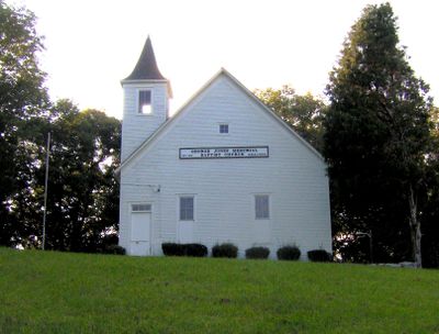
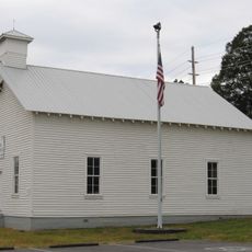
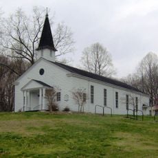
George Jones Memorial Baptist Church, Baptist church in Oak Ridge, Tennessee

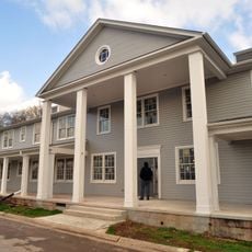
George Jones Memorial Baptist Church is a rectangular brick building with wood siding, a square bell tower, and a metal roof. The structure sits on Department of Energy property within a preserved landscape.

The building was founded in 1854 as Mount Zion Baptist Church and renamed in 1901 to honor a minister who donated land to the community. After this change, it became a central gathering place until the Wheat community was dissolved in 1942.

The church serves as a gathering place for descendants of the former Wheat community, who return annually to maintain ties to their shared past. Visitors can sense the connection to a community that disappeared more than 80 years ago.

Pedestrians can reach the building via public greenway trails that are open to visitors. Motor vehicles require special authorization since the church sits on restricted property.

This is the only remaining structure from the Wheat community, which vanished in 1942 to make way for the Manhattan Project. It stands as an unexpected survivor of a community entirely erased by the atomic research effort.

The community of curious travelers

AroundUs brings together thousands of curated places, local tips, and hidden gems, enriched daily by 60,000 contributors worldwide.

Start exploring
Location
GPS coordinates
35.93917,-84.37278
Latest update
December 13, 2025 11:41
Around this place
X-10 Graphite Reactor
United States of America

X-10 Graphite Reactor

5.1 km
Manhattan Project National Historical Park
United States of America

Manhattan Project National Historical Park

1.9 km
United States of America

Spallation Neutron Source

6.5 km
American Museum of Science and Energy
United States of America

American Museum of Science and Energy

13.6 km
Bussell Island
United States of America

Bussell Island

20.6 km
Fort Southwest Point
United States of America

Fort Southwest Point

16.6 km
United Church, The Chapel on the Hill
United States of America

United Church, The Chapel on the Hill

15.5 km
United States of America

University of Tennessee Arboretum

15 km
American Temperance University
United States of America

American Temperance University

16.2 km
Alexander Inn
United States of America

Alexander Inn

15.4 km
Children's Museum of Oak Ridge
United States of America

Children's Museum of Oak Ridge

13 km
Cornstalk Heights
United States of America

Cornstalk Heights

15.7 km
Avery Russell House
United States of America

Avery Russell House

20.1 km
New Bethel Baptist Church
United States of America

New Bethel Baptist Church

6.1 km
Roane County Courthouse
United States of America

Roane County Courthouse

14.9 km
Oak Ridge Historic District
United States of America

Oak Ridge Historic District

14.7 km
J. B. Jones House
United States of America

J. B. Jones House

19.9 km
Luther Brannon House
United States of America

Luther Brannon House

18.8 km
Colonial Hall
United States of America

Colonial Hall

12 km
Col. Gideon Morgan House
United States of America

Col. Gideon Morgan House

14.9 km
Freel Farm Mound Site
United States of America

Freel Farm Mound Site

14.4 km
Charles Vanden Bulck Bridge
United States of America

Charles Vanden Bulck Bridge

7.3 km
Princess Theatre
United States of America

Princess Theatre

16.1 km
Dr. Herman Postma Memorial Solway Bridge
United States of America

Dr. Herman Postma Memorial Solway Bridge

17.1 km
Bethel Valley Road Checking Station
United States of America

Bethel Valley Road Checking Station

15 km
Oak Ridge Turnpike Checking Station
United States of America

Oak Ridge Turnpike Checking Station

5.7 km
Bear Creek Road Checking Station
United States of America

Bear Creek Road Checking Station

13.5 km
Dr. Fred Stone, Sr., Hospital
United States of America

Dr. Fred Stone, Sr., Hospital

12.4 km
Show the full map
« George Jones Memorial Baptist Church - Baptist church in Oak Ridge, Tennessee » is provided by Around Us (aroundus.com). Images and texts are derived from Wikimedia project under a Creative Commons license. You are allowed to copy, distribute, and modify copies of this page, under the conditions set by the license, as long as this note is clearly visible.

Discover hidden gems everywhere you go!

From secret cafés to breathtaking viewpoints, skip the crowded tourist spots and find places that match your style. Our app makes it easy with voice search, smart filtering, route optimization, and insider tips from travelers worldwide. Download now for the complete mobile experience.

Around Us App Screenshot

A unique approach to discovering new places

Le Figaro

All the places worth exploring

France Info

A tailor-made excursion in just a few clicks

20 Minutes

Around Us
Travel Guide & Maps
Download

Send to your phone

QR Code
1

Open the camera app on your mobile.

2

Point at the QR code with your camera. A notification will appear.

3

Tap the notification to open the link.