Enable Location

We need your location to show you interesting places around you

Discover nearby places

Find interesting locations and hidden gems around you

Precise directions

Get accurate directions and distances to places

Your location is never shared with other users. It's only used when you tap the location button.

Fort Howard

Log in to your account

Start exploring — it's free

Trusted by 61,983 travelers worldwide

Continue with Google
Continue with Apple
or

We will send you a code to connect

By continuing, you accept our Terms and Conditions and our Privacy Policy

Check your inbox

We've sent a pincode in your inbox. Please enter the code below.

Fort Howard

Fort Howard, Military fortification in Green Bay, Wisconsin, United States.
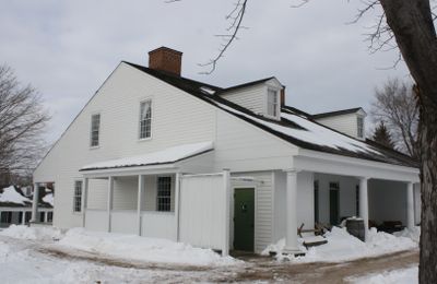
Fort Howard was a military fortification on the west bank of the Fox River, consisting of a wooden stockade with blockhouses. The compound included barracks, a hospital, officers' quarters, a school, and a jail to serve the stationed garrison.

The fort was built in 1816 following the War of 1812 to guard a key waterway linking the Great Lakes with Mississippi River trade. It served as a strategic military post to control commerce moving through the region.

The fort served the French and American community through social gatherings and military ceremonies that brought people together. It also housed the region's first school and medical facilities, making it a center for civilian life beyond military functions.

Three original buildings from the fort survive today at Heritage Hill State Historical Park and are open to visitors. The hospital, hospital ward, and officers' quarters display how daily life unfolded within the fortification.

Major Zachary Taylor, who would later become the 12th U.S. President, commanded the fort during its operational years. His leadership there marked an important chapter before his rise to national prominence.

The community of curious travelers

AroundUs brings together thousands of curated places, local tips, and hidden gems, enriched daily by 60,000 contributors worldwide.

Start exploring
Location
GPS coordinates
44.51670,-88.01670
Latest update
December 10, 2025 20:06
Around this place
City Stadium
United States of America

City Stadium

2.2 km
Zippin Pippin
United States of America

Zippin Pippin

3.2 km
Hagemeister Park
United States of America

Hagemeister Park

2.2 km
Bay Beach Amusement Park
United States of America

Bay Beach Amusement Park

3.3 km
Leo Frigo Memorial Bridge
United States of America

Leo Frigo Memorial Bridge

2 km
Brown County Veterans Memorial Arena
United States of America

Brown County Veterans Memorial Arena

3.7 km
Don Hutson Center
United States of America

Don Hutson Center

3.8 km
United States of America

Neville Public Museum of Brown County

193 m
Brown County Courthouse
United States of America

Brown County Courthouse

471 m
Meyer Theatre
United States of America

Meyer Theatre

333 m
St. Willebrord Catholic Church
United States of America

St. Willebrord Catholic Church

505 m
Receiver
United States of America

Receiver

290 m
Ray Nitschke Memorial Bridge
United States of America

Ray Nitschke Memorial Bridge

198 m
The Tarlton Theatre
United States of America

The Tarlton Theatre

463 m
Grassy Island Range Lights
United States of America

Grassy Island Range Lights

2.4 km
Bellin Building
United States of America

Bellin Building

273 m
Broadway-Walnut Historic District
United States of America

Broadway-Walnut Historic District

463 m
CityDeck
United States of America

CityDeck

88 m
Hazelwood
United States of America

Hazelwood

1.8 km
Astor Historic District
United States of America

Astor Historic District

1.5 km
Joel S. Fisk House
United States of America

Joel S. Fisk House

828 m
Christ Episcopal Church Complex
United States of America

Christ Episcopal Church Complex

507 m
Freimann Hotel Building
United States of America

Freimann Hotel Building

658 m
Broadway-Dousman Historic District
United States of America

Broadway-Dousman Historic District

629 m
Neville Public Museum
United States of America

Neville Public Museum

210 m
Kellogg Public Library and Neville Public Museum
United States of America

Kellogg Public Library and Neville Public Museum

556 m
West Theatre
United States of America

West Theatre

447 m
Green Bay Downtown Historic District
United States of America

Green Bay Downtown Historic District

409 m
Show the full map
« Fort Howard - Military fortification in Green Bay, Wisconsin, United States » is provided by Around Us (aroundus.com). Images and texts are derived from Wikimedia project under a Creative Commons license. You are allowed to copy, distribute, and modify copies of this page, under the conditions set by the license, as long as this note is clearly visible.

Discover hidden gems everywhere you go!

From secret cafés to breathtaking viewpoints, skip the crowded tourist spots and find places that match your style. Our app makes it easy with voice search, smart filtering, route optimization, and insider tips from travelers worldwide. Download now for the complete mobile experience.

Around Us App Screenshot

A unique approach to discovering new places

Le Figaro

All the places worth exploring

France Info

A tailor-made excursion in just a few clicks

20 Minutes

Around Us
Travel Guide & Maps
Download

Send to your phone

QR Code
1

Open the camera app on your mobile.

2

Point at the QR code with your camera. A notification will appear.

3

Tap the notification to open the link.