Ray Nitschke Memorial Bridge

Log in to your account

AroundUs is a community-driven map of interesting places, built by curious explorers like you. It grows with every review, story, and photo you share.
Connect to save your favorite spots, contribute locations, and create personalized routes.
Continue with Google
Continue with Apple
Continue with X
Continue with Facebook
Continue with email
By continuing, you accept our Terms and Conditions and our Privacy Policy
Create an account

Ray Nitschke Memorial Bridge

Add to collection
Map
Suggest a change
Share

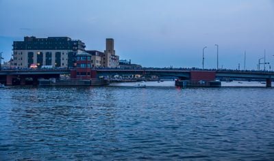
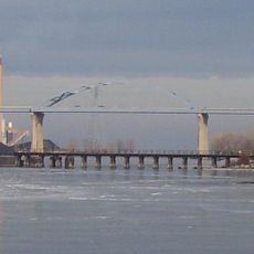
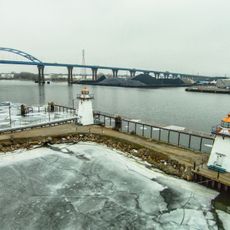
Ray Nitschke Memorial Bridge, Bascule bridge in Green Bay, US

The Ray Nitschke Memorial Bridge is a bascule bridge crossing the Fox River and connecting Main Street to US Highway 141 in downtown Green Bay. It has two movable leaves that lift upward to allow river traffic to pass underneath, while accommodating cars and pedestrians on the deck above.

This structure was built to replace an older Main Street Bridge from 1923 that required modernization. It opened in October 1998 as part of Green Bay's effort to improve its transportation infrastructure during that period.

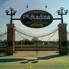
The bridge takes its name from Ray Nitschke, a linebacker for the Green Bay Packers, reflecting how deeply the city's identity is tied to American football. This connection becomes tangible when you walk across and notice how locals view the structure as part of their sporting heritage.

Traffic can be busy for both cars and pedestrians, especially during peak hours, so allow extra time when crossing. If river traffic is passing, the bridge leaves may lift suddenly, so stay alert and maintain distance from the edges if you happen to be on the bridge during an opening.

A cargo ship named the M.V. Kaye E. Barker struck the bridge's protective barrier system in 2017, causing nearby damage but proving the barrier's effectiveness. This collision highlighted how the protective system works to shield the main structure from large river traffic.

Location: Green Bay

Official opening: October 1998

GPS coordinates: 44.51837,-88.01585

Latest update: December 14, 2025 11:04

Photos
Around this place
City Stadium
United States of America

City Stadium

2.2 km
Zippin Pippin
United States of America

Zippin Pippin

3 km
Hagemeister Park
United States of America

Hagemeister Park

2.2 km
Bay Beach Amusement Park
United States of America

Bay Beach Amusement Park

3.1 km
Leo Frigo Memorial Bridge
United States of America

Leo Frigo Memorial Bridge

1.8 km
Brown County Veterans Memorial Arena
United States of America

Brown County Veterans Memorial Arena

3.8 km
Don Hutson Center
United States of America

Don Hutson Center

4 km
Fort Howard
United States of America

Fort Howard

198 m
United States of America

Neville Public Museum of Brown County

229 m
Brown County Courthouse
United States of America

Brown County Courthouse

627 m
Meyer Theatre
United States of America

Meyer Theatre

521 m
St. Willebrord Catholic Church
United States of America

St. Willebrord Catholic Church

680 m
Receiver
United States of America

Receiver

211 m
The Tarlton Theatre
United States of America

The Tarlton Theatre

576 m
Grassy Island Range Lights
United States of America

Grassy Island Range Lights

2.2 km
Bellin Building
United States of America

Bellin Building

462 m
Broadway-Walnut Historic District
United States of America

Broadway-Walnut Historic District

465 m
CityDeck
United States of America

CityDeck

255 m
Hazelwood
United States of America

Hazelwood

2 km
Astor Historic District
United States of America

Astor Historic District

1.7 km
Joel S. Fisk House
United States of America

Joel S. Fisk House

861 m
Christ Episcopal Church Complex
United States of America

Christ Episcopal Church Complex

599 m
Freimann Hotel Building
United States of America

Freimann Hotel Building

855 m
Broadway-Dousman Historic District
United States of America

Broadway-Dousman Historic District

536 m
Neville Public Museum
United States of America

Neville Public Museum

216 m
Kellogg Public Library and Neville Public Museum
United States of America

Kellogg Public Library and Neville Public Museum

707 m
West Theatre
United States of America

West Theatre

558 m
Green Bay Downtown Historic District
United States of America

Green Bay Downtown Historic District

463 m
Show the full map
Reviews

Visited this place? Tap the stars to rate it and share your experience / photos with the community! Try now! You can cancel it anytime.

« Ray Nitschke Memorial Bridge - Bascule bridge in Green Bay, US » is provided by Around Us (aroundus.com). Images and texts are derived from Wikimedia project under a Creative Commons license. You are allowed to copy, distribute, and modify copies of this page, under the conditions set by the license, as long as this note is clearly visible.

Discover hidden gems everywhere you go!

From secret cafés to breathtaking viewpoints, skip the crowded tourist spots and find places that match your style. Our app makes it easy with voice search, smart filtering, route optimization, and insider tips from travelers worldwide. Download now for the complete mobile experience.

Around Us App Screenshot

A unique approach to discovering new places

Le Figaro

All the places worth exploring

France Info

A tailor-made excursion in just a few clicks

20 Minutes