Enable Location

We need your location to show you interesting places around you

Discover nearby places

Find interesting locations and hidden gems around you

Precise directions

Get accurate directions and distances to places

Your location is never shared with other users. It's only used when you tap the location button.

Log in to your account

Start exploring — it's free

Trusted by 63,123 travelers worldwide

Continue with Google
Continue with Apple
or

We will send you a code to connect

By continuing, you accept our Terms and Conditions and our Privacy Policy

Check your inbox

We've sent a pincode in your inbox. Please enter the code below.

Glastenbury Mountain
Discussion Reviews Photo
9.9k Popularity

Glastenbury Mountain, Mountain summit in Bennington County, Vermont, United States.

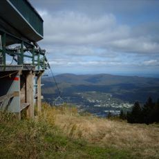
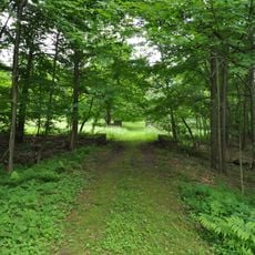
Glastenbury Mountain rises to about 3,748 feet within the Green Mountain National Forest and features distinct drainage patterns across each slope. The summit itself holds an observation tower, while a shelter stands slightly to the south.

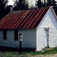
The mountain's surroundings underwent major changes in the late 1800s due to logging operations and sawmills that reshaped both the landscape and local economy. This era left lasting marks on the forest composition of the region.

The summit marks a meeting point for long-distance hikers, where the Long Trail and Appalachian Trail converge into a shared route. Many trekkers view this junction as a meaningful milestone during their extended journeys through the region.

Visitors should know that the summit is accessible via marked trails and provides infrastructure such as an observation tower for views. A shelter nearby allows hikers to seek cover if weather conditions change.

The summit holds five ancient stone cairns discovered by archaeologists, which may mark visits by earlier people. The largest of these cairns measures over 3 feet across and suggests the long-term importance of this location.

The community of curious travelers

AroundUs brings together thousands of curated places, local tips, and hidden gems, enriched daily by 60,000 contributors worldwide.

Start exploring
GPS coordinates
42.97813,-73.07122
Latest update
December 10, 2025 15:56
Around this place
Mount Snow
United States of America

Mount Snow

12.2 km
Green Mountain National Forest
United States of America

Green Mountain National Forest

108.2 km
Bennington Battle Monument
United States of America

Bennington Battle Monument

15.4 km
United States of America

Haystack Mountain

14.3 km
Catamount Tavern
United States of America

Catamount Tavern

15.5 km
Bennington Historical Museum
United States of America

Bennington Historical Museum

15.5 km
Park-McCullough Historic House
United States of America

Park-McCullough Historic House

15.4 km
Silk Covered Bridge
United States of America

Silk Covered Bridge

14.7 km
Paper Mill Village Bridge
United States of America

Paper Mill Village Bridge

15.1 km
United States of America

Prospect Mountain

11.5 km
Woodford State Park
United States of America

Woodford State Park

10.1 km
Downtown Bennington Historic District
United States of America

Downtown Bennington Historic District

15.1 km
Chiselville Covered Bridge
United States of America

Chiselville Covered Bridge

11.6 km
Old Bennington High School
United States of America

Old Bennington High School

14.7 km
East Arlington Village Historic District
United States of America

East Arlington Village Historic District

11 km
Gov. Jonas Galusha Homestead
United States of America

Gov. Jonas Galusha Homestead

11.1 km
McCullough Free Library
United States of America

McCullough Free Library

15.2 km
Frederick Squire House
United States of America

Frederick Squire House

14.5 km
Munro-Hawkins House
United States of America

Munro-Hawkins House

11.4 km
District No. 1 Schoolhouse
United States of America

District No. 1 Schoolhouse

7.4 km
Cora B. Whitney School
United States of America

Cora B. Whitney School

14.1 km
Furnace Grove Historic District
United States of America

Furnace Grove Historic District

12.5 km
Carrigan Lane Historic District
United States of America

Carrigan Lane Historic District

14.3 km
Holden-Leonard Workers Housing Historic District
United States of America

Holden-Leonard Workers Housing Historic District

15 km
Pratt-McDaniels-LaFlamme House
United States of America

Pratt-McDaniels-LaFlamme House

15.6 km
School Street Duplexes
United States of America

School Street Duplexes

14.5 km
Dutchman's Tavern
United States of America

Dutchman's Tavern

14.9 km
Robert Frost Stone House Museum at Bennington College
United States of America

Robert Frost Stone House Museum at Bennington College

12.3 km
Show the full map
Reviews
Share your experience

No review yet

Discussions
Start a discussion...

No discussion yet

« Glastenbury Mountain - Mountain summit in Bennington County, Vermont, United States » is provided by Around Us (aroundus.com). Images and texts are derived from Wikimedia project under a Creative Commons license. You are allowed to copy, distribute, and modify copies of this page, under the conditions set by the license, as long as this note is clearly visible.

Discover hidden gems everywhere you go!

From secret cafés to breathtaking viewpoints, skip the crowded tourist spots and find places that match your style. Our app makes it easy with voice search, smart filtering, route optimization, and insider tips from travelers worldwide. Download now for the complete mobile experience.

Around Us App Screenshot

A unique approach to discovering new places

Le Figaro

All the places worth exploring

France Info

A tailor-made excursion in just a few clicks

20 Minutes

Around Us
Travel Guide & Maps
Download

Send to your phone

QR Code
1

Open the camera app on your mobile.

2

Point at the QR code with your camera. A notification will appear.

3

Tap the notification to open the link.