Chiselville Covered Bridge

Log in to your account

AroundUs is a community-driven map of interesting places, built by curious explorers like you. It grows with every review, story, and photo you share.
Connect to save your favorite spots, contribute locations, and create personalized routes.
Continue with Google
Continue with Apple
Continue with X
Continue with Facebook
Continue with email
By continuing, you accept our Terms and Conditions and our Privacy Policy
Create an account
Add to collection
Map
Suggest a change
Share

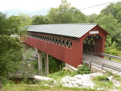
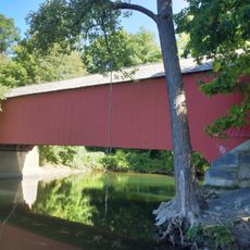
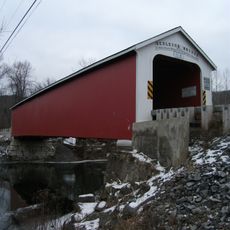
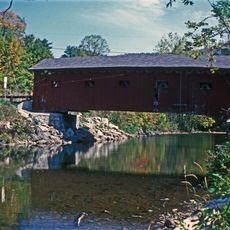
Chiselville Covered Bridge, Historic covered bridge in Bennington County, United States.

Chiselville Covered Bridge is a wooden structure that spans the Roaring Branch Brook and connects both sides of East Arlington Road. The bridge employs the Towne Lattice Truss design to achieve its 117-foot length.

Daniel Oatman constructed this bridge in 1870 using the innovative Towne Lattice Truss design. Steel reinforcements were added in 1973 after overloaded gravel trucks caused damage to the wooden frame.

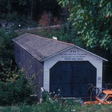
A quirky warning sign on the bridge jokingly tells drivers they must pay a dollar if they exceed walking speed while crossing. This playful rule reflects the local care taken to protect the wooden structure from damage.

The bridge sits about 100 feet (30 meters) above the water, creating a notable elevation that visitors will notice while crossing. Slow passage on foot or by vehicle allows time to observe the wooden construction and surrounding landscape.

The interior reveals the distinctive latticed framework that is the hallmark of the Towne design, visible as you pass through. This 19th-century engineering approach created a surprisingly strong structure despite using only wooden materials.

Location: Bennington County

Inception: 1870

GPS coordinates: 43.07217,-73.13320

Latest update: December 14, 2025 18:46

Photos
Around this place
Hildene
United States of America

Hildene

8.8 km
Green Mountain National Forest
United States of America

Green Mountain National Forest

97.9 km
Stratton Mountain
United States of America

Stratton Mountain

17 km
Equinox Mountain
United States of America

Equinox Mountain

10.5 km
Shushan Bridge
United States of America

Shushan Bridge

17.4 km
Eagleville Bridge
United States of America

Eagleville Bridge

14.7 km
Rexleigh Bridge
United States of America

Rexleigh Bridge

19.4 km
The American Museum of Fly Fishing
United States of America

The American Museum of Fly Fishing

11.9 km
Park-McCullough Historic House
United States of America

Park-McCullough Historic House

18.5 km
Arlington Green Covered Bridge
United States of America

Arlington Green Covered Bridge

8 km
Manley-Lefevre House
United States of America

Manley-Lefevre House

18 km
Salem Historic District
United States of America

Salem Historic District

19.3 km
David Mathews House
United States of America

David Mathews House

18.6 km
Equinox House Historic District
United States of America

Equinox House Historic District

11.1 km
East Arlington Village Historic District
United States of America

East Arlington Village Historic District

1.5 km
Gov. Jonas Galusha Homestead
United States of America

Gov. Jonas Galusha Homestead

11.1 km
McCullough Free Library
United States of America

McCullough Free Library

18.3 km
White Creek Historic District
United States of America

White Creek Historic District

16.9 km
Munro-Hawkins House
United States of America

Munro-Hawkins House

14.2 km
Amos Lawrence House
United States of America

Amos Lawrence House

12.2 km
Kent Neighborhood Historic District
United States of America

Kent Neighborhood Historic District

18.8 km
Hard Farm Homestead
United States of America

Hard Farm Homestead

7.7 km
Stratton Mountain Lookout Tower
United States of America

Stratton Mountain Lookout Tower

17 km
Pastime Pinball
United States of America

Pastime Pinball

13.1 km
Robert Frost Stone House Museum at Bennington College
United States of America

Robert Frost Stone House Museum at Bennington College

16.6 km
The Georgi on the Battenkill Community Park & Museum
United States of America

The Georgi on the Battenkill Community Park & Museum

17.3 km
North Bennington Historic District
United States of America

North Bennington Historic District

18.1 km
Center Shaftsbury Historic District
United States of America

Center Shaftsbury Historic District

11.6 km
Show the full map
Reviews

Visited this place? Tap the stars to rate it and share your experience / photos with the community! Try now! You can cancel it anytime.

« Chiselville Covered Bridge - Historic covered bridge in Bennington County, United States » is provided by Around Us (aroundus.com). Images and texts are derived from Wikimedia project under a Creative Commons license. You are allowed to copy, distribute, and modify copies of this page, under the conditions set by the license, as long as this note is clearly visible.

Discover hidden gems everywhere you go!

From secret cafés to breathtaking viewpoints, skip the crowded tourist spots and find places that match your style. Our app makes it easy with voice search, smart filtering, route optimization, and insider tips from travelers worldwide. Download now for the complete mobile experience.

Around Us App Screenshot

A unique approach to discovering new places

Le Figaro

All the places worth exploring

France Info

A tailor-made excursion in just a few clicks

20 Minutes