Enable Location

We need your location to show you interesting places around you

Discover nearby places

Find interesting locations and hidden gems around you

Precise directions

Get accurate directions and distances to places

Your location is never shared with other users. It's only used when you tap the location button.

Eagleville Bridge

Log in to your account

Start exploring — it's free

Trusted by 61,891 travelers worldwide

Continue with Google
Continue with Apple
or

We will send you a code to connect

By continuing, you accept our Terms and Conditions and our Privacy Policy

Check your inbox

We've sent a pincode in your inbox. Please enter the code below.

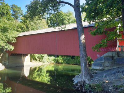
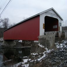
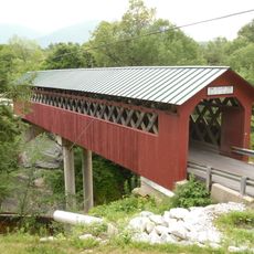
Eagleville Bridge, Covered bridge in Washington County, New York.

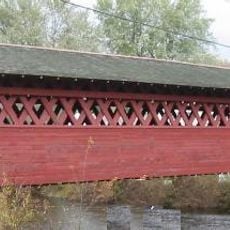
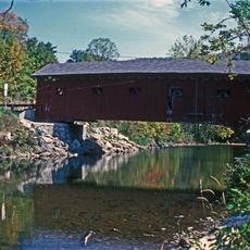
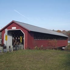
The Eagleville Bridge is a wooden covered structure crossing the Battenkill River in Washington County, built with a lattice design of diagonal planks held together by wooden pegs. It spans approximately 100 feet and continues to carry vehicle traffic between the communities of Jackson and Salem.

Built in 1858 by local craftsman Ephraim Clapp, the bridge represents mid-19th century engineering techniques. It was added to the National Register of Historic Places in 1978, confirming its importance to American building history.

This bridge stands as one of four remaining structures of its kind in the county, showing how 19th-century communities crossed rivers with wood and skill. Walking through it, you see a piece of local building tradition that has lasted for generations.

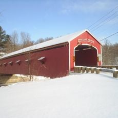
You can approach from the west via State Route 313, and since the bridge remains open to traffic, pedestrians can walk across and view the interior. Daytime visits work best, when light filters through the wooden structure and makes the construction details visible.

In 1977, flooding damaged the east abutment, yet the lattice construction held firm and prevented complete collapse. This event revealed how flexible and resilient the old wooden design could be against the forces of nature.

The community of curious travelers

AroundUs brings together thousands of curated places, local tips, and hidden gems, enriched daily by 60,000 contributors worldwide.

Start exploring
Location
GPS coordinates
43.08325,-73.31372
Latest update
December 11, 2025 11:08
Around this place
Hildene
United States of America

Hildene

20.1 km
Equinox Mountain
United States of America

Equinox Mountain

18.4 km
Buskirk Bridge
United States of America

Buskirk Bridge

17 km
Shushan Bridge
United States of America

Shushan Bridge

2.8 km
Bennington Battlefield State Historic Site
United States of America

Bennington Battlefield State Historic Site

16 km
Rexleigh Bridge
United States of America

Rexleigh Bridge

6.7 km
Park-McCullough Historic House
United States of America

Park-McCullough Historic House

18.1 km
Burt Henry Covered Bridge
United States of America

Burt Henry Covered Bridge

19.6 km
Arlington Green Covered Bridge
United States of America

Arlington Green Covered Bridge

7.9 km
Paper Mill Village Bridge
United States of America

Paper Mill Village Bridge

20.1 km
Salem Historic District
United States of America

Salem Historic District

10 km
Henry House
United States of America

Henry House

20 km
David Mathews House
United States of America

David Mathews House

16.2 km
Chiselville Covered Bridge
United States of America

Chiselville Covered Bridge

14.7 km
Hoosick Falls Historic District
United States of America

Hoosick Falls Historic District

20.5 km
Burton Hall
United States of America

Burton Hall

17.3 km
Cambridge Historic District
United States of America

Cambridge Historic District

8.5 km
East Arlington Village Historic District
United States of America

East Arlington Village Historic District

14 km
Gov. Jonas Galusha Homestead
United States of America

Gov. Jonas Galusha Homestead

13.7 km
McCullough Free Library
United States of America

McCullough Free Library

18.1 km
White Creek Historic District
United States of America

White Creek Historic District

12.6 km
Munro-Hawkins House
United States of America

Munro-Hawkins House

16.5 km
Village of Greenwich Historic District
United States of America

Village of Greenwich Historic District

15.1 km
Hard Farm Homestead
United States of America

Hard Farm Homestead

19.5 km
Robert Frost Stone House Museum at Bennington College
United States of America

Robert Frost Stone House Museum at Bennington College

18.6 km
The Georgi on the Battenkill Community Park & Museum
United States of America

The Georgi on the Battenkill Community Park & Museum

2.6 km
North Bennington Historic District
United States of America

North Bennington Historic District

18 km
Center Shaftsbury Historic District
United States of America

Center Shaftsbury Historic District

14.2 km
Show the full map
« Eagleville Bridge - Covered bridge in Washington County, New York » is provided by Around Us (aroundus.com). Images and texts are derived from Wikimedia project under a Creative Commons license. You are allowed to copy, distribute, and modify copies of this page, under the conditions set by the license, as long as this note is clearly visible.

Discover hidden gems everywhere you go!

From secret cafés to breathtaking viewpoints, skip the crowded tourist spots and find places that match your style. Our app makes it easy with voice search, smart filtering, route optimization, and insider tips from travelers worldwide. Download now for the complete mobile experience.

Around Us App Screenshot

A unique approach to discovering new places

Le Figaro

All the places worth exploring

France Info

A tailor-made excursion in just a few clicks

20 Minutes

Around Us
Travel Guide & Maps
Download

Send to your phone

QR Code
1

Open the camera app on your mobile.

2

Point at the QR code with your camera. A notification will appear.

3

Tap the notification to open the link.