Enable Location

We need your location to show you interesting places around you

Discover nearby places

Find interesting locations and hidden gems around you

Precise directions

Get accurate directions and distances to places

Your location is never shared with other users. It's only used when you tap the location button.

Paper Mill Village Bridge

Log in to your account

Start exploring — it's free

Trusted by 61,899 travelers worldwide

Continue with Google
Continue with Apple
or

We will send you a code to connect

By continuing, you accept our Terms and Conditions and our Privacy Policy

Check your inbox

We've sent a pincode in your inbox. Please enter the code below.

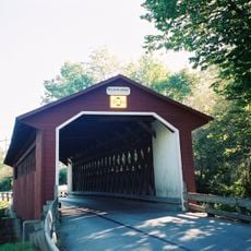
Paper Mill Village Bridge, Covered bridge in Bennington, US.

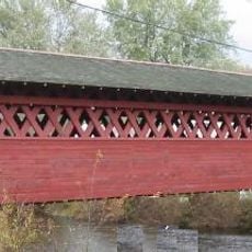
Paper Mill Village Bridge is a covered bridge that spans the Walloomsac River with wooden vertical board siding and horizontal portal ends. It features a Town lattice truss design with doubled truss members that strengthen the overall structure.

The bridge was built in 1889 by Charles F. Sears using the Town lattice truss method. It gained recognition on the National Register of Historic Places in 1973, marking its importance to the region's heritage.

The bridge connects to a paper mill that once shaped the town's economy and working life. It stands as a reminder of when local industries defined the rhythm of the community.

The bridge sits on Murphy Road and remains open to vehicle traffic during the day. The single-lane passage requires careful navigation, especially when approaching vehicles from the opposite direction.

This is the longest covered bridge in Bennington County, a distinction that reflects its substantial construction. The reinforced design with doubled structural members demonstrates engineering that has kept it sound for generations.

The community of curious travelers

AroundUs brings together thousands of curated places, local tips, and hidden gems, enriched daily by 60,000 contributors worldwide.

Start exploring
Location
Inception
1889
GPS coordinates
42.91278,-73.23361
Latest update
December 14, 2025 11:03
Around this place
Bennington Battle Monument
United States of America

Bennington Battle Monument

3 km
Bennington Battlefield State Historic Site
United States of America

Bennington Battlefield State Historic Site

6.4 km
Catamount Tavern
United States of America

Catamount Tavern

3.4 km
Bennington Historical Museum
United States of America

Bennington Historical Museum

3.8 km
Park-McCullough Historic House
United States of America

Park-McCullough Historic House

2 km
Silk Covered Bridge
United States of America

Silk Covered Bridge

735 m
Burt Henry Covered Bridge
United States of America

Burt Henry Covered Bridge

1.8 km
Henry House
United States of America

Henry House

1.9 km
David Mathews House
United States of America

David Mathews House

4.6 km
Downtown Bennington Historic District
United States of America

Downtown Bennington Historic District

4.8 km
Old Bennington High School
United States of America

Old Bennington High School

5.2 km
One World Conservation Center
United States of America

One World Conservation Center

6.4 km
Gov. Jonas Galusha Homestead
United States of America

Gov. Jonas Galusha Homestead

8.7 km
McCullough Free Library
United States of America

McCullough Free Library

2 km
White Creek Historic District
United States of America

White Creek Historic District

8 km
Frederick Squire House
United States of America

Frederick Squire House

4.5 km
Munro-Hawkins House
United States of America

Munro-Hawkins House

5.3 km
Cora B. Whitney School
United States of America

Cora B. Whitney School

5.4 km
Furnace Grove Historic District
United States of America

Furnace Grove Historic District

7 km
Carrigan Lane Historic District
United States of America

Carrigan Lane Historic District

4.9 km
Holden-Leonard Workers Housing Historic District
United States of America

Holden-Leonard Workers Housing Historic District

4.2 km
Pratt-McDaniels-LaFlamme House
United States of America

Pratt-McDaniels-LaFlamme House

5.4 km
School Street Duplexes
United States of America

School Street Duplexes

4.5 km
Dutchman's Tavern
United States of America

Dutchman's Tavern

4.5 km
Robert Frost Stone House Museum at Bennington College
United States of America

Robert Frost Stone House Museum at Bennington College

3.1 km
North Bennington Historic District
United States of America

North Bennington Historic District

2.1 km
Center Shaftsbury Historic District
United States of America

Center Shaftsbury Historic District

8.1 km
The Orchards
United States of America

The Orchards

5 km
Show the full map
« Paper Mill Village Bridge - Covered bridge in Bennington, US » is provided by Around Us (aroundus.com). Images and texts are derived from Wikimedia project under a Creative Commons license. You are allowed to copy, distribute, and modify copies of this page, under the conditions set by the license, as long as this note is clearly visible.

Discover hidden gems everywhere you go!

From secret cafés to breathtaking viewpoints, skip the crowded tourist spots and find places that match your style. Our app makes it easy with voice search, smart filtering, route optimization, and insider tips from travelers worldwide. Download now for the complete mobile experience.

Around Us App Screenshot

A unique approach to discovering new places

Le Figaro

All the places worth exploring

France Info

A tailor-made excursion in just a few clicks

20 Minutes

Around Us
Travel Guide & Maps
Download

Send to your phone

QR Code
1

Open the camera app on your mobile.

2

Point at the QR code with your camera. A notification will appear.

3

Tap the notification to open the link.