Burt Henry Covered Bridge

Log in to your account

AroundUs is a community-driven map of interesting places, built by curious explorers like you. It grows with every review, story, and photo you share.
Connect to save your favorite spots, contribute locations, and create personalized routes.
Continue with Google
Continue with Apple
Continue with X
Continue with Facebook
Continue with email
By continuing, you accept our Terms and Conditions and our Privacy Policy
Create an account
Add to collection
Map
Suggest a change
Share

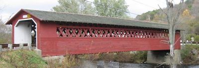
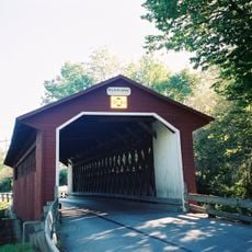
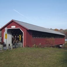
Burt Henry Covered Bridge, Covered bridge in Bennington, US

Burt Henry Covered Bridge is a wooden structure in Bennington that carries traffic across a creek while a protective roof shields the crossing from weather. The bridge features a timber frame construction typical of covered bridges built during the 1800s.

Built in 1840, this crossing was essential for connecting rural communities across waterways during the early transportation era. The construction methods reflect engineering practices that rural Vermont relied on during the 1800s.

The structure reflects how communities once depended on local craftsmanship for essential infrastructure. Visitors can observe the careful joinery and wooden construction that supported daily life in this region.

The bridge is open year-round with convenient parking nearby and walking paths that let you explore the surroundings. Visiting during daylight hours gives you the best view of the wooden construction and the creek landscape.

The bridge uses a timber truss design that achieves surprising strength with relatively modest amounts of wood. This efficient engineering allowed builders to span the creek without wasting materials while keeping the structure stable for heavy loads.
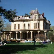
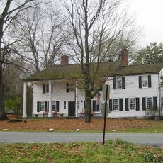
Location: Bennington

Inception: 1840

GPS coordinates: 42.91260,-73.25550

Latest update: December 13, 2025 17:04

Photos
Around this place
Bennington Battle Monument
United States of America

Bennington Battle Monument

4.2 km
Bennington Battlefield State Historic Site
United States of America

Bennington Battlefield State Historic Site

4.9 km
Catamount Tavern
United States of America

Catamount Tavern

4.5 km
Bennington Historical Museum
United States of America

Bennington Historical Museum

4.9 km
Park-McCullough Historic House
United States of America

Park-McCullough Historic House

1.9 km
Silk Covered Bridge
United States of America

Silk Covered Bridge

2.4 km
Paper Mill Village Bridge
United States of America

Paper Mill Village Bridge

1.8 km
Henry House
United States of America

Henry House

475 m
David Mathews House
United States of America

David Mathews House

3.5 km
Downtown Bennington Historic District
United States of America

Downtown Bennington Historic District

6.1 km
Estabrook Octagon House
United States of America

Estabrook Octagon House

8.2 km
Hoosick Falls Historic District
United States of America

Hoosick Falls Historic District

7.9 km
Old Bennington High School
United States of America

Old Bennington High School

6.6 km
One World Conservation Center
United States of America

One World Conservation Center

7.3 km
McCullough Free Library
United States of America

McCullough Free Library

2 km
White Creek Historic District
United States of America

White Creek Historic District

7.1 km
Breese-Reynolds House
United States of America

Breese-Reynolds House

8.3 km
Frederick Squire House
United States of America

Frederick Squire House

5.9 km
Munro-Hawkins House
United States of America

Munro-Hawkins House

6.2 km
Cora B. Whitney School
United States of America

Cora B. Whitney School

6.9 km
Carrigan Lane Historic District
United States of America

Carrigan Lane Historic District

6.4 km
Holden-Leonard Workers Housing Historic District
United States of America

Holden-Leonard Workers Housing Historic District

5.4 km
Pratt-McDaniels-LaFlamme House
United States of America

Pratt-McDaniels-LaFlamme House

6.5 km
School Street Duplexes
United States of America

School Street Duplexes

5.9 km
Dutchman's Tavern
United States of America

Dutchman's Tavern

5.8 km
Robert Frost Stone House Museum at Bennington College
United States of America

Robert Frost Stone House Museum at Bennington College

4.4 km
North Bennington Historic District
United States of America

North Bennington Historic District

2.3 km
The Orchards
United States of America

The Orchards

5.7 km
Show the full map
Reviews

Visited this place? Tap the stars to rate it and share your experience / photos with the community! Try now! You can cancel it anytime.

« Burt Henry Covered Bridge - Covered bridge in Bennington, US » is provided by Around Us (aroundus.com). Images and texts are derived from Wikimedia project under a Creative Commons license. You are allowed to copy, distribute, and modify copies of this page, under the conditions set by the license, as long as this note is clearly visible.

Discover hidden gems everywhere you go!

From secret cafés to breathtaking viewpoints, skip the crowded tourist spots and find places that match your style. Our app makes it easy with voice search, smart filtering, route optimization, and insider tips from travelers worldwide. Download now for the complete mobile experience.

Around Us App Screenshot

A unique approach to discovering new places

Le Figaro

All the places worth exploring

France Info

A tailor-made excursion in just a few clicks

20 Minutes