Enable Location

We need your location to show you interesting places around you

Discover nearby places

Find interesting locations and hidden gems around you

Precise directions

Get accurate directions and distances to places

Your location is never shared with other users. It's only used when you tap the location button.

Buskirk Bridge

Log in to your account

Start exploring — it's free

Trusted by 61,899 travelers worldwide

Continue with Google
Continue with Apple
or

We will send you a code to connect

By continuing, you accept our Terms and Conditions and our Privacy Policy

Check your inbox

We've sent a pincode in your inbox. Please enter the code below.

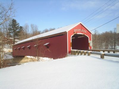
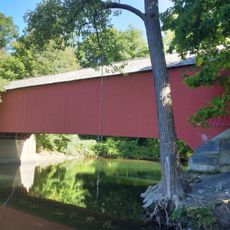
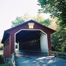
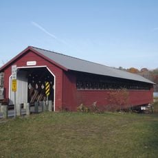
Buskirk Bridge, Historic covered bridge in Washington County, New York, US.

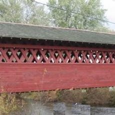
Buskirk Bridge is a covered wooden bridge crossing the Hoosic River with a span of approximately 165 feet and internal bracing using the Howe truss system. The interior reveals a lattice of wooden beams and supports that distributes weight and allows the structure to carry modern vehicle traffic.

Built in 1857 by builders Peter Osterhauth, Charles Newman, and James Roberts, the bridge was later recognized as a historic structure worthy of preservation. It represents one of the surviving examples of mid-19th-century engineering that continues to serve its original purpose.

This is one of four remaining covered bridges in Washington County, and visitors can see the wooden joinery and building methods typical of rural construction from that era. The red wooden structure draws photographers and history enthusiasts who want to experience this style of 19th-century engineering firsthand.

Access is via State Route 67, and visitors should note that this is an active roadway with regular vehicle traffic. The bridge spans between two counties, so it remains in everyday use and travelers should be cautious when exploring it.

This is New York State's only covered bridge linking two counties jointly managed by both administrations. The shared responsibility between separate county governments is rare and makes this crossing a curious example of cross-county cooperation.

The community of curious travelers

AroundUs brings together thousands of curated places, local tips, and hidden gems, enriched daily by 60,000 contributors worldwide.

Start exploring
Location
GPS coordinates
42.95833,-73.43333
Latest update
December 9, 2025 18:49
Around this place
Boot Monument
United States of America

Boot Monument

17.7 km
Saratoga National Historical Park
United States of America

Saratoga National Historical Park

17.2 km
Shushan Bridge
United States of America

Shushan Bridge

16.4 km
Bennington Battlefield State Historic Site
United States of America

Bennington Battlefield State Historic Site

10.8 km
Eagleville Bridge
United States of America

Eagleville Bridge

17 km
Park-McCullough Historic House
United States of America

Park-McCullough Historic House

15.6 km
Silk Covered Bridge
United States of America

Silk Covered Bridge

17.8 km
Burt Henry Covered Bridge
United States of America

Burt Henry Covered Bridge

15.4 km
Paper Mill Village Bridge
United States of America

Paper Mill Village Bridge

17 km
Henry House
United States of America

Henry House

15.5 km
David Mathews House
United States of America

David Mathews House

13.1 km
Stillwater Bridge
United States of America

Stillwater Bridge

17.9 km
Estabrook Octagon House
United States of America

Estabrook Octagon House

9.5 km
Hoosick Falls Historic District
United States of America

Hoosick Falls Historic District

9.2 km
Dickinson Hill Fire Tower
United States of America

Dickinson Hill Fire Tower

18.4 km
Burton Hall
United States of America

Burton Hall

17.8 km
Tibbits House
United States of America

Tibbits House

13.4 km
Cambridge Historic District
United States of America

Cambridge Historic District

8.7 km
McCullough Free Library
United States of America

McCullough Free Library

15.7 km
White Creek Historic District
United States of America

White Creek Historic District

11.8 km
Breese-Reynolds House
United States of America

Breese-Reynolds House

14.3 km
Munro-Hawkins House
United States of America

Munro-Hawkins House

18.3 km
Tomhannock Methodist Episcopal Church
United States of America

Tomhannock Methodist Episcopal Church

13.9 km
Village of Greenwich Historic District
United States of America

Village of Greenwich Historic District

15.8 km
Robert Frost Stone House Museum at Bennington College
United States of America

Robert Frost Stone House Museum at Bennington College

18.4 km
The Georgi on the Battenkill Community Park & Museum
United States of America

The Georgi on the Battenkill Community Park & Museum

16.2 km
Stillwater Blockhouse
United States of America

Stillwater Blockhouse

18.3 km
North Bennington Historic District
United States of America

North Bennington Historic District

15.9 km
Show the full map
« Buskirk Bridge - Historic covered bridge in Washington County, New York, US » is provided by Around Us (aroundus.com). Images and texts are derived from Wikimedia project under a Creative Commons license. You are allowed to copy, distribute, and modify copies of this page, under the conditions set by the license, as long as this note is clearly visible.

Discover hidden gems everywhere you go!

From secret cafés to breathtaking viewpoints, skip the crowded tourist spots and find places that match your style. Our app makes it easy with voice search, smart filtering, route optimization, and insider tips from travelers worldwide. Download now for the complete mobile experience.

Around Us App Screenshot

A unique approach to discovering new places

Le Figaro

All the places worth exploring

France Info

A tailor-made excursion in just a few clicks

20 Minutes

Around Us
Travel Guide & Maps
Download

Send to your phone

QR Code
1

Open the camera app on your mobile.

2

Point at the QR code with your camera. A notification will appear.

3

Tap the notification to open the link.