Enable Location

We need your location to show you interesting places around you

Discover nearby places

Find interesting locations and hidden gems around you

Precise directions

Get accurate directions and distances to places

Your location is never shared with other users. It's only used when you tap the location button.

Stratton Mountain

Log in to your account

Start exploring — it's free

Trusted by 63,116 travelers worldwide

Continue with Google
Continue with Apple
or

We will send you a code to connect

By continuing, you accept our Terms and Conditions and our Privacy Policy

Check your inbox

We've sent a pincode in your inbox. Please enter the code below.

Stratton Mountain
Discussion Reviews 1 Photos
13.6k Popularity

Stratton Mountain, Mountain peak in Windham County, Vermont, United States.

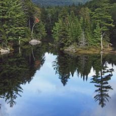
Stratton Mountain is a peak in Vermont featuring two distinct summits surrounded by thick forest cover and a sprawling ski resort complex. The area encompasses numerous ski runs, lifts, rental facilities, restaurants, and lodging options spread across the slopes.

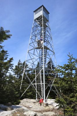
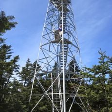
A lookout tower was built on the summit in 1934 by the Civilian Conservation Corps and later recognized on the National Register of Historic Places in 1992. This structure reflects the mountain's role during the Depression era as a site for public works projects.

Stratton Mountain School, established in 1972, prepares students for winter sports competitions while maintaining academic excellence, producing numerous Olympic athletes.

The best time to visit depends on whether you prefer winter skiing or summer hiking, as activities change seasonally across the slopes. Visitors should come prepared for varying weather conditions and bring appropriate clothing for their chosen season.

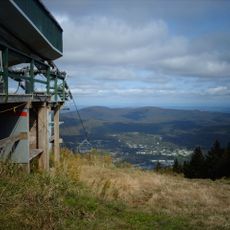
The summit played a key role in conceiving two major hiking trails: the Long Trail emerged from James Taylor's inspiration while standing atop the peak, and Benton MacKaye envisioned the Appalachian Trail while at this same location. Both of these trail systems grew from ideas formed on this hilltop.

The community of curious travelers

AroundUs brings together thousands of curated places, local tips, and hidden gems, enriched daily by 60,000 contributors worldwide.

Start exploring
Location
GPS coordinates
43.08626,-72.92489
Latest update
December 7, 2025 20:25
Around this place
Mount Snow
United States of America

Mount Snow

14.2 km
Hildene
United States of America

Hildene

13.9 km
Green Mountain National Forest
United States of America

Green Mountain National Forest

96.8 km
Equinox Mountain
United States of America

Equinox Mountain

18.1 km
Bill Wilson House
United States of America

Bill Wilson House

18.4 km
United States of America

Haystack Mountain

19.2 km
United States of America

Mount Aeolus

19.5 km
The American Museum of Fly Fishing
United States of America

The American Museum of Fly Fishing

14.7 km
Jamaica State Park
United States of America

Jamaica State Park

12.5 km
Scott Covered Bridge
United States of America

Scott Covered Bridge

19 km
Equinox House Historic District
United States of America

Equinox House Historic District

14.7 km
Townshend State Park
United States of America

Townshend State Park

19.6 km
Chiselville Covered Bridge
United States of America

Chiselville Covered Bridge

17 km
Dover Town Hall
United States of America

Dover Town Hall

18.7 km
West Townshend Stone Arch Bridge
United States of America

West Townshend Stone Arch Bridge

17.5 km
East Arlington Village Historic District
United States of America

East Arlington Village Historic District

18.1 km
South Londonderry Village Historic District
United States of America

South Londonderry Village Historic District

14.6 km
Follett Stone Arch Bridge Historic District
United States of America

Follett Stone Arch Bridge Historic District

18 km
Windham Village Historic District
United States of America

Windham Village Historic District

19 km
Londonderry Town House
United States of America

Londonderry Town House

15 km
Amos Lawrence House
United States of America

Amos Lawrence House

13.6 km
Corse-Shippee House
United States of America

Corse-Shippee House

17.9 km
Hard Farm Homestead
United States of America

Hard Farm Homestead

13.7 km
South Windham Village Historic District
United States of America

South Windham Village Historic District

17.8 km
Stratton Mountain Lookout Tower
United States of America

Stratton Mountain Lookout Tower

8 m
Pastime Pinball
United States of America

Pastime Pinball

14.7 km
Hamilton Falls
United States of America

Hamilton Falls

14.2 km
West Townshend Village Historic District
United States of America

West Townshend Village Historic District

17.4 km
Show the full map
Reviews
Share your experience

No review yet

Discussions
Start a discussion...

No discussion yet

« Stratton Mountain - Mountain peak in Windham County, Vermont, United States » is provided by Around Us (aroundus.com). Images and texts are derived from Wikimedia project under a Creative Commons license. You are allowed to copy, distribute, and modify copies of this page, under the conditions set by the license, as long as this note is clearly visible.

Discover hidden gems everywhere you go!

From secret cafés to breathtaking viewpoints, skip the crowded tourist spots and find places that match your style. Our app makes it easy with voice search, smart filtering, route optimization, and insider tips from travelers worldwide. Download now for the complete mobile experience.

Around Us App Screenshot

A unique approach to discovering new places

Le Figaro

All the places worth exploring

France Info

A tailor-made excursion in just a few clicks

20 Minutes

Around Us
Travel Guide & Maps
Download

Send to your phone

QR Code
1

Open the camera app on your mobile.

2

Point at the QR code with your camera. A notification will appear.

3

Tap the notification to open the link.