Enable Location

We need your location to show you interesting places around you

Discover nearby places

Find interesting locations and hidden gems around you

Precise directions

Get accurate directions and distances to places

Your location is never shared with other users. It's only used when you tap the location button.

Grafton State School

Log in to your account

Start exploring — it's free

Trusted by 61,912 travelers worldwide

Continue with Google
Continue with Apple
or

We will send you a code to connect

By continuing, you accept our Terms and Conditions and our Privacy Policy

Check your inbox

We've sent a pincode in your inbox. Please enter the code below.

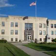
Grafton State School, Historic educational district in Grafton, North Dakota, United States.

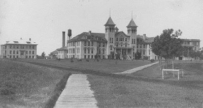
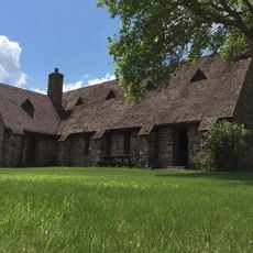
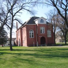
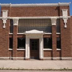
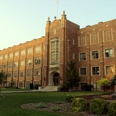
Grafton State School is a historic district in Grafton, North Dakota, made up of several brick buildings arranged across a large property. The structures were designed in the Prairie School style and feature a network of underground passages that once connected them.

The facility opened in 1901 as North Dakota's main institution for residential care and education. Over its lifetime, it went through major changes in how it operated and what services it provided to residents.

The names and purposes of the buildings here changed along with how society viewed care and education. Walking through the grounds, you notice how the layout was designed to keep residents engaged in daily routines and work.

You can walk around the grounds and look at the preserved buildings from the outside. Before you visit, it helps to learn about the property online, since not all buildings are open to the public.

The underground tunnel network was built to solve a practical problem in North Dakota's harsh winters. Staff and residents could move between buildings without stepping outside into the cold.

The community of curious travelers

AroundUs brings together thousands of curated places, local tips, and hidden gems, enriched daily by 60,000 contributors worldwide.

Start exploring
Location
GPS coordinates
48.41861,-97.42389
Latest update
December 12, 2025 17:46
Around this place
Alerus Center
United States of America

Alerus Center

61.2 km
AN/FPQ-16 PARCS
United States of America

AN/FPQ-16 PARCS

47 km
North Dakota Mill and Elevator
United States of America

North Dakota Mill and Elevator

60 km
Turtle River State Park
United States of America

Turtle River State Park

53.9 km
Grand Forks Air Defense Sector
United States of America

Grand Forks Air Defense Sector

52.7 km
Icelandic State Park
United States of America

Icelandic State Park

46.9 km
446th Missile Squadron
United States of America

446th Missile Squadron

51 km
Red River State Recreation Area
United States of America

Red River State Recreation Area

61.3 km
447th Missile Squadron
United States of America

447th Missile Squadron

51 km
448th Missile Squadron
United States of America

448th Missile Squadron

51 km
United States of America

Vikur Lutheran Church at Mountain

43.7 km
St. Catherine's Church
United States of America

St. Catherine's Church

60.1 km
St. Stanislaus Church Historic District
United States of America

St. Stanislaus Church Historic District

18.7 km
Strand Theatre
United States of America

Strand Theatre

1 km
Avalon Theatre
United States of America

Avalon Theatre

59 km
Pembina County Courthouse
United States of America

Pembina County Courthouse

44 km
K. J. Taralseth Company
United States of America

K. J. Taralseth Company

54.1 km
Walsh County Courthouse
United States of America

Walsh County Courthouse

1.5 km
Oxford House
United States of America

Oxford House

61.1 km
Grand Forks County Fairgrounds WPA Structures
United States of America

Grand Forks County Fairgrounds WPA Structures

60.4 km
Grand Forks Riverside Neighborhood Historic District
United States of America

Grand Forks Riverside Neighborhood Historic District

60.6 km
Larimore City Hall
United States of America

Larimore City Hall

59.1 km
Forest River State Bank
United States of America

Forest River State Bank

23 km
United States of America

Minto School

14.5 km
University of North Dakota Historic District
United States of America

University of North Dakota Historic District

61.1 km
United States of America

State Bank of Edinburg

33.6 km
Edinburg WPA Auditorium
United States of America

Edinburg WPA Auditorium

33.6 km
Cavalier Theatre
United States of America

Cavalier Theatre

44.3 km
Show the full map
« Grafton State School - Historic educational district in Grafton, North Dakota, United States » is provided by Around Us (aroundus.com). Images and texts are derived from Wikimedia project under a Creative Commons license. You are allowed to copy, distribute, and modify copies of this page, under the conditions set by the license, as long as this note is clearly visible.

Discover hidden gems everywhere you go!

From secret cafés to breathtaking viewpoints, skip the crowded tourist spots and find places that match your style. Our app makes it easy with voice search, smart filtering, route optimization, and insider tips from travelers worldwide. Download now for the complete mobile experience.

Around Us App Screenshot

A unique approach to discovering new places

Le Figaro

All the places worth exploring

France Info

A tailor-made excursion in just a few clicks

20 Minutes

Around Us
Travel Guide & Maps
Download

Send to your phone

QR Code
1

Open the camera app on your mobile.

2

Point at the QR code with your camera. A notification will appear.

3

Tap the notification to open the link.