Enable Location

We need your location to show you interesting places around you

Discover nearby places

Find interesting locations and hidden gems around you

Precise directions

Get accurate directions and distances to places

Your location is never shared with other users. It's only used when you tap the location button.

Grassland

Log in to your account

Start exploring — it's free

Trusted by 62,855 travelers worldwide

Continue with Google
Continue with Apple
or

We will send you a code to connect

By continuing, you accept our Terms and Conditions and our Privacy Policy

Check your inbox

We've sent a pincode in your inbox. Please enter the code below.

Grassland, human settlement in Anne Arundel County, Maryland, United States of America

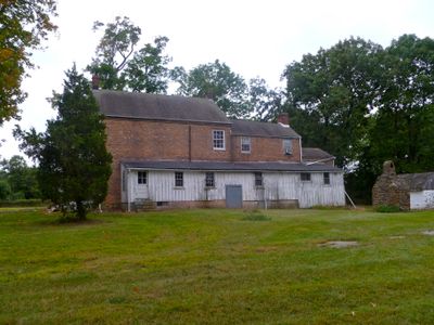
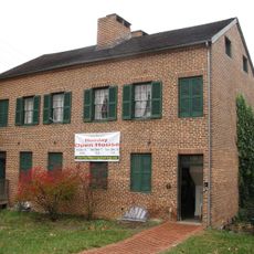
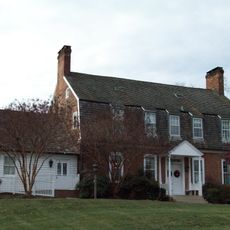
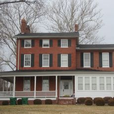
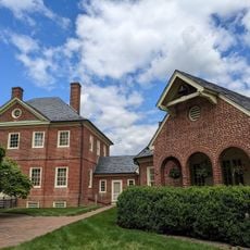
Grassland is a historic plantation in Anne Arundel County, Maryland, added to the National Register of Historic Places in 1984. The site features a three-part brick house built around 1853 and auxiliary structures including a stone smokehouse, remains of a summer kitchen, and ruins of a bank barn used for storage and animal care.

The site was established as a plantation around 1853 and reflects antebellum building styles. The main house was constructed in phases over time, while workers built auxiliary structures to support farming operations and daily life on the property.

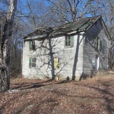
The name Grassland refers to the open fields that define the property. The site reflects how enslaved and free workers lived and labored on a Maryland plantation, with structures built for cooking, food storage, and daily tasks still present on the grounds.

The site is accessible by appointment and managed by the Grassland Foundation, which has protected it since 1989. Visitors should know that the buildings are currently in poor condition with overgrown vegetation, so care is needed when exploring the grounds.

The three-part brick house displays a rare construction method where sections were added over several years. This phase-by-phase expansion shows how plantation owners gradually enlarged their homes as economic conditions allowed.

The community of curious travelers

AroundUs brings together thousands of curated places, local tips, and hidden gems, enriched daily by 60,000 contributors worldwide.

Start exploring
GPS coordinates
39.11830,-76.77810
Latest update
February 9, 2026 07:45
Around this place
National Cryptologic Museum
United States of America

National Cryptologic Museum

483 m
Laurel Park
United States of America

Laurel Park

4.8 km
Bollman Truss Railroad Bridge
United States of America

Bollman Truss Railroad Bridge

4.5 km
Savage Mill
United States of America

Savage Mill

4.6 km
NSA Hall of Honor
United States of America

NSA Hall of Honor

483 m
Patuxent Research Refuge
United States of America

Patuxent Research Refuge

6.9 km
National Vigilance Park
United States of America

National Vigilance Park

767 m
Joe Cannon Stadium
United States of America

Joe Cannon Stadium

6.6 km
Rosa Bonheur Memorial Park
United States of America

Rosa Bonheur Memorial Park

7.6 km
Savage Mill Trail
United States of America

Savage Mill Trail

4.4 km
Laurel Museum
United States of America

Laurel Museum

6.9 km
Christ Church Guilford
United States of America

Christ Church Guilford

8.5 km
Savage Mill Historic District
United States of America

Savage Mill Historic District

4.7 km
Old Laurel High School
United States of America

Old Laurel High School

6.8 km
Trinity Church
United States of America

Trinity Church

6.9 km
Avondale Mill
United States of America

Avondale Mill

6 km
United States of America

Piney Orchard Nature Preserve

7.8 km
Laurel Branch Library
United States of America

Laurel Branch Library

7 km
Snow Hill
United States of America

Snow Hill

7.4 km
Epiphany Chapel and Church House
United States of America

Epiphany Chapel and Church House

6.9 km
Woodwardville Historic District
United States of America

Woodwardville Historic District

8.3 km
Mt. Moriah Lodge No. 7
United States of America

Mt. Moriah Lodge No. 7

3.4 km
Asbury Methodist Episcopal Church
United States of America

Asbury Methodist Episcopal Church

3.4 km
Gude House
United States of America

Gude House

8.6 km
Citizens State Bank
United States of America

Citizens State Bank

7.1 km
ROI Construction
United States of America

ROI Construction

4.9 km
Cinemark Egyptian 24 and XD
United States of America

Cinemark Egyptian 24 and XD

6 km
Montpelier House Museum
United States of America

Montpelier House Museum

8.3 km
Show the full map
« Grassland - human settlement in Anne Arundel County, Maryland, United States of America » is provided by Around Us (aroundus.com). Images and texts are derived from Wikimedia project under a Creative Commons license. You are allowed to copy, distribute, and modify copies of this page, under the conditions set by the license, as long as this note is clearly visible.

Discover hidden gems everywhere you go!

From secret cafés to breathtaking viewpoints, skip the crowded tourist spots and find places that match your style. Our app makes it easy with voice search, smart filtering, route optimization, and insider tips from travelers worldwide. Download now for the complete mobile experience.

Around Us App Screenshot

A unique approach to discovering new places

Le Figaro

All the places worth exploring

France Info

A tailor-made excursion in just a few clicks

20 Minutes

Around Us
Travel Guide & Maps
Download

Send to your phone

QR Code
1

Open the camera app on your mobile.

2

Point at the QR code with your camera. A notification will appear.

3

Tap the notification to open the link.