Goat Island Light

Log in to your account

AroundUs is a community-driven map of interesting places, built by curious explorers like you. It grows with every review, story, and photo you share.
Connect to save your favorite spots, contribute locations, and create personalized routes.
Continue with Google
Continue with Apple
Continue with X
Continue with Facebook
Continue with email
By continuing, you accept our Terms and Conditions and our Privacy Policy
Create an account
Add to collection
Map
Suggest a change
Share

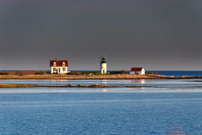
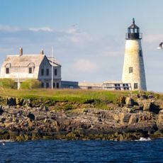
Goat Island Light, Lighthouse at Cape Porpoise Harbor, Maine, United States

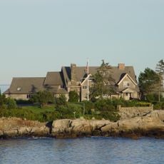
Goat Island Light is a lighthouse on the southern shore of Cape Porpoise Harbor in Maine, featuring a white cylindrical tower topped with a black lantern that rises about 7.5 meters (25 feet) high. An L-shaped wooden keeper's house from 1859 connects to the tower via a covered walkway, forming an integrated operational complex.

Congress authorized construction of a navigation aid in 1833, and the first tower began operation in 1835 to guide vessels safely into the harbor. The keeper's residence was added in 1859, reflecting how the station grew and evolved to better support its operational needs.

The name comes from goats that once grazed on the island, shaping its early identity as a working landscape. Visitors on boat tours can observe how keepers lived in the connected dwellings while managing the light station.

The lighthouse is viewable from the mainland near State Route 9 north of Kennebunkport, and boat tours provide closer access to observe the structures and harbor setting. Plan your visit during calm weather and good visibility to appreciate the details and surrounding landscape.

The keeper's house connects to the tower through a covered walkway, a practical design that sheltered residents from harsh coastal weather. This direct link between living quarters and workplace was a thoughtful arrangement that reflected the demands of lighthouse keeping.

Location: York County

Inception: 1835

Height: 7.5 m

GPS coordinates: 43.35778,-70.42500

Latest update: December 12, 2025 07:52

Photos
Around this place
Wedding Cake House
United States of America

Wedding Cake House

7.9 km
Seashore Trolley Museum
United States of America

Seashore Trolley Museum

7.7 km
Rachel Carson National Wildlife Refuge
United States of America

Rachel Carson National Wildlife Refuge

9.4 km
Wood Island Light
United States of America

Wood Island Light

13.5 km
Bourne Mansion
United States of America

Bourne Mansion

9.9 km
Wells National Estuarine Research Reserve
United States of America

Wells National Estuarine Research Reserve

10.6 km
Brick Store Museum
United States of America

Brick Store Museum

9.7 km
United States of America

National Streetcar Museum

7.8 km
Cape Arundel Summer Colony Historic District
United States of America

Cape Arundel Summer Colony Historic District

3.9 km
Kennebunkport Historic District
United States of America

Kennebunkport Historic District

4.2 km
Kennebunk Historic District
United States of America

Kennebunk Historic District

9.6 km
Kennebunk River Club
United States of America

Kennebunk River Club

4 km
Abbott Graves House
United States of America

Abbott Graves House

3.9 km
Timber Point
United States of America

Timber Point

5.1 km
Capt. Nathaniel Lord Mansion
United States of America

Capt. Nathaniel Lord Mansion

4 km
Clock Farm
United States of America

Clock Farm

5.3 km
Melville Walker House
United States of America

Melville Walker House

3.9 km
Lord Mansion
United States of America

Lord Mansion

9.5 km
James Montgomery Flagg House
United States of America

James Montgomery Flagg House

12.2 km
First Parish Meetinghouse
United States of America

First Parish Meetinghouse

13.1 km
Maine Trolley Cars
United States of America

Maine Trolley Cars

7.6 km
John Tarr House
United States of America

John Tarr House

12.6 km
Wallingford Hall
United States of America

Wallingford Hall

10.2 km
United States Customhouse
United States of America

United States Customhouse

4.1 km
Lower Alewive Historic District
United States of America

Lower Alewive Historic District

13.8 km
Old Kennebunk High School
United States of America

Old Kennebunk High School

9.4 km
Libby's Colonial Tea Room
United States of America

Libby's Colonial Tea Room

10.9 km
James Smith Homestead
United States of America

James Smith Homestead

14 km
Show the full map
Reviews

Visited this place? Tap the stars to rate it and share your experience / photos with the community! Try now! You can cancel it anytime.

« Goat Island Light - Lighthouse at Cape Porpoise Harbor, Maine, United States » is provided by Around Us (aroundus.com). Images and texts are derived from Wikimedia project under a Creative Commons license. You are allowed to copy, distribute, and modify copies of this page, under the conditions set by the license, as long as this note is clearly visible.

Discover hidden gems everywhere you go!

From secret cafés to breathtaking viewpoints, skip the crowded tourist spots and find places that match your style. Our app makes it easy with voice search, smart filtering, route optimization, and insider tips from travelers worldwide. Download now for the complete mobile experience.

Around Us App Screenshot

A unique approach to discovering new places

Le Figaro

All the places worth exploring

France Info

A tailor-made excursion in just a few clicks

20 Minutes