Enable Location

We need your location to show you interesting places around you

Discover nearby places

Find interesting locations and hidden gems around you

Precise directions

Get accurate directions and distances to places

Your location is never shared with other users. It's only used when you tap the location button.

Kennebunk River Club

Log in to your account

Save your favorite places
Create custom travel routes
Rate and review places
Access the full interactive map
Continue with Google
Continue with Apple
Continue with email
By continuing, you accept our Terms and Conditions and our Privacy Policy
Create an account
Add to collection
Map
Suggest a change
Share

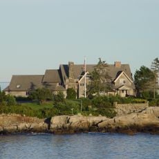
Kennebunk River Club, Social club in Kennebunkport, Maine, US.

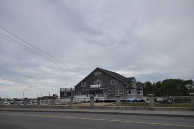
The Kennebunk River Club is a private establishment built on wooden pilings over the river with a broad gabled roof and symmetrical windows. Its structure is defined by its position on Ocean Avenue, overlooking the water and housing various facilities for members.

A group of 13 summer residents founded the club in 1888 as a Lobster, Boat, and Canoe Club to support water-based leisure activities. Architect Frederick W. Stickney designed the main building, which has maintained its original structure to the present day.

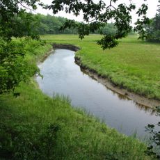
The building reflects how the local community has long connected with waterfront life, serving as a gathering place for those interested in boating and river pursuits. It shows how wealthy summer visitors in the late 1800s spent their leisure time along Maine's coast.

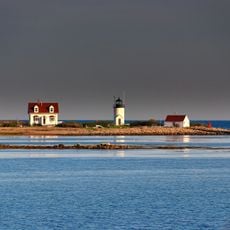
Access is limited to members only, so visitors can only view the exterior from Ocean Avenue and surrounding public areas. The best views of the building and river come from public pathways along the waterfront nearby.

Members of the Penobscot Nation built and rented canoes to club participants during the summer season as a longstanding tradition. This collaboration reveals a lesser-known historical connection between the club and the region's Indigenous community.

Location: Maine

GPS coordinates: 43.35028,-70.47333

Latest update: December 14, 2025 18:13

Photos
Around this place
Wedding Cake House
United States of America

Wedding Cake House

5 km
Seashore Trolley Museum
United States of America

Seashore Trolley Museum

6.7 km
Rachel Carson National Wildlife Refuge
United States of America

Rachel Carson National Wildlife Refuge

5.5 km
Goat Island Light
United States of America

Goat Island Light

4 km
Bourne Mansion
United States of America

Bourne Mansion

6.8 km
Wells National Estuarine Research Reserve
United States of America

Wells National Estuarine Research Reserve

6.6 km
Brick Store Museum
United States of America

Brick Store Museum

6.6 km
United States of America

National Streetcar Museum

6.7 km
Cape Arundel Summer Colony Historic District
United States of America

Cape Arundel Summer Colony Historic District

852 m
Kennebunkport Historic District
United States of America

Kennebunkport Historic District

1.4 km
Kennebunk Historic District
United States of America

Kennebunk Historic District

6.6 km
Abbott Graves House
United States of America

Abbott Graves House

404 m
Timber Point
United States of America

Timber Point

8.2 km
Capt. Nathaniel Lord Mansion
United States of America

Capt. Nathaniel Lord Mansion

961 m
Clock Farm
United States of America

Clock Farm

7.2 km
Melville Walker House
United States of America

Melville Walker House

1.1 km
Lord Mansion
United States of America

Lord Mansion

6.5 km
James Montgomery Flagg House
United States of America

James Montgomery Flagg House

15.3 km
First Parish Meetinghouse
United States of America

First Parish Meetinghouse

14.7 km
Spiller Farm Paleoindian Site
United States of America

Spiller Farm Paleoindian Site

10.8 km
Maine Trolley Cars
United States of America

Maine Trolley Cars

6.5 km
John Tarr House
United States of America

John Tarr House

14.6 km
Wallingford Hall
United States of America

Wallingford Hall

6.9 km
United States Customhouse
United States of America

United States Customhouse

1.3 km
Lower Alewive Historic District
United States of America

Lower Alewive Historic District

11.5 km
Old Kennebunk High School
United States of America

Old Kennebunk High School

6.3 km
Libby's Colonial Tea Room
United States of America

Libby's Colonial Tea Room

7 km
James Smith Homestead
United States of America

James Smith Homestead

11.8 km
Show the full map
Reviews

Visited this place? Tap the stars to rate it and share your experience / photos with the community! Try now! You can cancel it anytime.

« Kennebunk River Club - Social club in Kennebunkport, Maine, US » is provided by Around Us (aroundus.com). Images and texts are derived from Wikimedia project under a Creative Commons license. You are allowed to copy, distribute, and modify copies of this page, under the conditions set by the license, as long as this note is clearly visible.

Discover hidden gems everywhere you go!

From secret cafés to breathtaking viewpoints, skip the crowded tourist spots and find places that match your style. Our app makes it easy with voice search, smart filtering, route optimization, and insider tips from travelers worldwide. Download now for the complete mobile experience.

Around Us App Screenshot

A unique approach to discovering new places

Le Figaro

All the places worth exploring

France Info

A tailor-made excursion in just a few clicks

20 Minutes