Hammond Wood Historic District

Log in to your account

AroundUs is a community-driven map of interesting places, built by curious explorers like you. It grows with every review, story, and photo you share.
Connect to save your favorite spots, contribute locations, and create personalized routes.
Continue with Google
Continue with Apple
Continue with X
Continue with Facebook
Continue with email
By continuing, you accept our Terms and Conditions and our Privacy Policy
Create an account
Add to collection
Map
Suggest a change
Share

Hammond Wood Historic District, Mid-century modern residential district in Wheaton, United States.

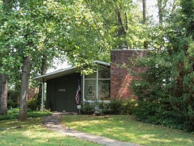
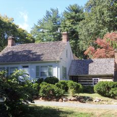
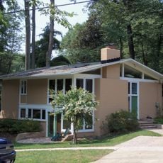
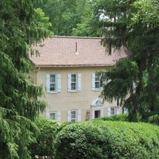
Hammond Wood Historic District is a residential neighborhood in Wheaton comprising 58 single-family homes built between 1949 and 1951 in mid-century modern architectural style. The homes sit across approximately 15 acres bounded by Veirs Mill Road, Highview Avenue, Pendleton Drive, College View Drive, and Woodridge Avenue.

The district emerged during the post-World War II period as part of the suburban development movement across the Washington D.C. metropolitan region. This planned community with its contemporary homes reflects the growth and optimism of the postwar era.

The district shows how residents inhabit a thoughtfully planned community where architecture was designed to work with existing trees and green spaces rather than against them. You can see this integration in how the homes sit naturally among the landscape today.

The area is easily accessible from the surrounding main roads and works well for a leisurely walk through the quiet residential streets. Visitors can observe the architecture from public pathways and explore how the homes are arranged among the trees.

Architect Charles Goodman designed the homes with an unusual approach for the time: he positioned buildings around existing trees rather than removing them to clear the land. This sensitivity to the natural landscape was uncommon in postwar suburban development and continues to define the district.

Location: Montgomery County

GPS coordinates: 39.04750,-77.06890

Latest update: December 14, 2025 13:05

Photos
Around this place
Washington D.C. Temple
United States of America

Washington D.C. Temple

3.7 km
National Museum of Health and Medicine
United States of America

National Museum of Health and Medicine

4.5 km
Brookside Gardens
United States of America

Brookside Gardens

3 km
National Park Seminary
United States of America

National Park Seminary

4.2 km
Wilkins Estate
United States of America

Wilkins Estate

4 km
Bethesda Meeting House
United States of America

Bethesda Meeting House

4.9 km
Wheaton Regional Park
United States of America

Wheaton Regional Park

3.3 km
Riley-Bolten House
United States of America

Riley-Bolten House

4.6 km
Matthew Henson State Park
United States of America

Matthew Henson State Park

3.4 km
Wheaton Youth Center
United States of America

Wheaton Youth Center

1.5 km
Young Israel Shomrai Emunah of Greater Washington
United States of America

Young Israel Shomrai Emunah of Greater Washington

3.5 km
Woodend
United States of America

Woodend

5 km
Kensington Historic District
United States of America

Kensington Historic District

2.6 km
North Bethesda Market
United States of America

North Bethesda Market

3.8 km
Rock Creek Woods Historic District
United States of America

Rock Creek Woods Historic District

860 m
Cedar Lane Unitarian Universalist Church
United States of America

Cedar Lane Unitarian Universalist Church

4.2 km
Milimar
United States of America

Milimar

4.9 km
Garrett Park Historic District
United States of America

Garrett Park Historic District

2.6 km
Music Center at Strathmore
United States of America

Music Center at Strathmore

3.4 km
Mansion at Strathmore
United States of America

Mansion at Strathmore

3.5 km
Westfield Wheaton North
United States of America

Westfield Wheaton North

1.5 km
Noyes Library For Young Children
United States of America

Noyes Library For Young Children

2.6 km
Silver Spring Assembly
United States of America

Silver Spring Assembly

2.3 km
Aspen Hill Library
United States of America

Aspen Hill Library

3.7 km
Brookside Gardens Conservatory
United States of America

Brookside Gardens Conservatory

3.2 km
Luxmanor Park
United States of America

Luxmanor Park

5.1 km
Gifford Pinchot Forest Building
United States of America

Gifford Pinchot Forest Building

4.6 km
Kensington Park Library
United States of America

Kensington Park Library

2.3 km
Show the full map
Reviews

Visited this place? Tap the stars to rate it and share your experience / photos with the community! Try now! You can cancel it anytime.

« Hammond Wood Historic District - Mid-century modern residential district in Wheaton, United States » is provided by Around Us (aroundus.com). Images and texts are derived from Wikimedia project under a Creative Commons license. You are allowed to copy, distribute, and modify copies of this page, under the conditions set by the license, as long as this note is clearly visible.

Discover hidden gems everywhere you go!

From secret cafés to breathtaking viewpoints, skip the crowded tourist spots and find places that match your style. Our app makes it easy with voice search, smart filtering, route optimization, and insider tips from travelers worldwide. Download now for the complete mobile experience.

Around Us App Screenshot

A unique approach to discovering new places

Le Figaro

All the places worth exploring

France Info

A tailor-made excursion in just a few clicks

20 Minutes