Hope Memorial Bridge

Log in to your account

AroundUs is a community-driven map of interesting places, built by curious explorers like you. It grows with every review, story, and photo you share.
Connect to save your favorite spots, contribute locations, and create personalized routes.
Continue with Google
Continue with Apple
Continue with X
Continue with Facebook
Continue with email
By continuing, you accept our Terms and Conditions and our Privacy Policy
Create an account
Add to collection
Map
Suggest a change
Share

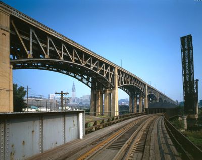
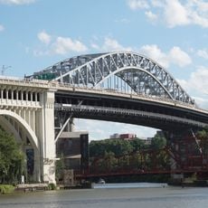
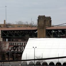
Hope Memorial Bridge, Art Deco truss bridge in Cleveland, United States.

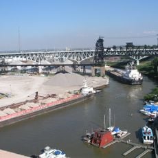
Hope Memorial Bridge is a truss bridge in Cleveland, United States, crossing the Cuyahoga River and linking Lorain Avenue with Carnegie Avenue. The steel and concrete structure rests on massive piers that carry vehicles, pedestrians, and cyclists over the water.

Following a public petition in 1902 and bond approval for eight million dollars in 1927, the structure opened in 1932 as the Lorain-Carnegie Bridge. It received its current name in 1983 to honor Harry Hope, father of entertainer Bob Hope and a stonemason who worked on the construction.

Eight monumental Guardian sculptures stand on four stone pylons, each holding a vehicle as a symbol of transportation in their hands. These figures from the early 1930s combine modern design with traditional stonework, drawing the attention of pedestrians and cyclists crossing today.

The span rises about 93 feet (28 meters) above the water, allowing vessels to pass underneath, while separate paths for pedestrians and cyclists have been available since 2012. Walking or cycling across offers views of the river and the industrial sites along its banks.

Frank Walker designed the Guardian figures holding different vehicle types, including a truck, a bus, and a hay wagon, representing the evolution of transportation. Henry Hering carved each sculpture from solid stone, with each figure standing over 35 feet (10 meters) tall and weighing several tons.

Location: Cleveland

Inception: 1932

GPS coordinates: 41.48940,-81.69360

Latest update: December 5, 2025 22:25

Photos
Around this place
Terminal Tower
United States of America

Terminal Tower

995 m
West Side Market
United States of America

West Side Market

962 m
200 Public Square
United States of America

200 Public Square

1.2 km
Soldiers' and Sailors' Monument
United States of America

Soldiers' and Sailors' Monument

1.1 km
Detroit–Superior Bridge
United States of America

Detroit–Superior Bridge

912 m
AT&T Huron Road Building
United States of America

AT&T Huron Road Building

1.1 km
Rockefeller Building
United States of America

Rockefeller Building

1 km
Time Warner Cable Amphitheater
United States of America

Time Warner Cable Amphitheater

568 m
Irishtown Bend
United States of America

Irishtown Bend

943 m
55 Public Square
United States of America

55 Public Square

1.2 km
Carl B. Stokes Federal Court House Building
United States of America

Carl B. Stokes Federal Court House Building

844 m
George V. Voinovich Bridges
United States of America

George V. Voinovich Bridges

474 m
Innerbelt Bridge
United States of America

Innerbelt Bridge

474 m
Landmark Office Towers
United States of America

Landmark Office Towers

888 m
The Residences at 668
United States of America

The Residences at 668

1.2 km
St. Mary's on the Flats
United States of America

St. Mary's on the Flats

563 m
Frank J. Lausche State Office Building
United States of America

Frank J. Lausche State Office Building

951 m
Annunciation Church
United States of America

Annunciation Church

724 m
75 Public Square
United States of America

75 Public Square

1.2 km
Chase Financial Plaza
United States of America

Chase Financial Plaza

874 m
Park Building
United States of America

Park Building

1.1 km
Irishtown Bend Archeological District
United States of America

Irishtown Bend Archeological District

943 m
The Crittenden
United States of America

The Crittenden

1.1 km
Soldiers' and Sailors' Monument
United States of America

Soldiers' and Sailors' Monument

1.1 km
Western Reserve Fire Museum
United States of America

Western Reserve Fire Museum

683 m
Abraham Lincoln's Funeral in Cleveland
United States of America

Abraham Lincoln's Funeral in Cleveland

1.1 km
Lower Prospect–Huron Historic District
United States of America

Lower Prospect–Huron Historic District

1.2 km
Moses Cleaveland's "Capitol Town"
United States of America

Moses Cleaveland's "Capitol Town"

1 km
Show the full map
Reviews

Visited this place? Tap the stars to rate it and share your experience / photos with the community! Try now! You can cancel it anytime.

« Hope Memorial Bridge - Art Deco truss bridge in Cleveland, United States » is provided by Around Us (aroundus.com). Images and texts are derived from Wikimedia project under a Creative Commons license. You are allowed to copy, distribute, and modify copies of this page, under the conditions set by the license, as long as this note is clearly visible.

Discover hidden gems everywhere you go!

From secret cafés to breathtaking viewpoints, skip the crowded tourist spots and find places that match your style. Our app makes it easy with voice search, smart filtering, route optimization, and insider tips from travelers worldwide. Download now for the complete mobile experience.

Around Us App Screenshot

A unique approach to discovering new places

Le Figaro

All the places worth exploring

France Info

A tailor-made excursion in just a few clicks

20 Minutes