Chest opened
+${chestReward.xp} XP
Explorer
NOUVEAU ×${chestReward.collectible.quantity}
tapez pour fermer
Chest locked

Open chests in the app

Around Us is built for your phone — chests unlock when you walk, explore and capture nearby places.

Enable Location

We need your location to show you interesting places around you

Discover nearby places

Find interesting locations and hidden gems around you

Precise directions

Get accurate directions and distances to places

Your location is never shared with other users. It's only used when you tap the location button.

Log in to your account

Start exploring — it's free

Trusted by 72,879 travelers worldwide

Continue with Google
Continue with Apple
or

We will send you a code to connect

By continuing, you accept our Terms and Conditions and our Privacy Policy

Check your inbox

We've sent a pincode in your inbox. Please enter the code below.

Huntersville State Forest
Discussion Reviews Photo
1.6k Popularity

Huntersville State Forest, State forest in Wadena County, United States

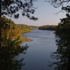
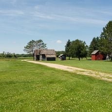
Huntersville State Forest is a large woodland area spanning multiple counties in Minnesota with varied terrain. The landscape features upland areas dominated by red pine, jack pine, aspen, and paper birch trees across sandy soils.

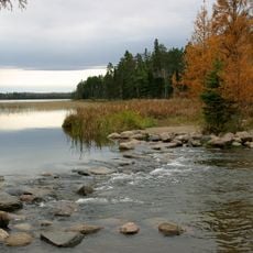
The forest area has roots in logging operations that began when Shell City was founded as a timber camp in 1879. The Crow Wing and Shell Rivers served as vital transportation routes where steamboats and barges moved logs downstream.

The Minnesota Department of Natural Resources manages half of the forest, while private entities control the remaining portion for sustainable resource management.

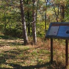
The forest provides extensive trails suitable for different activities with dedicated routes for motorcycles, horses, and hikers from main access points. Visitors should check seasonal conditions before heading out, as weather can affect trail quality and accessibility.

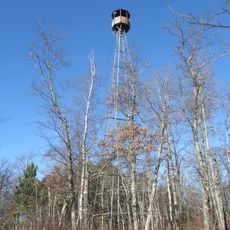
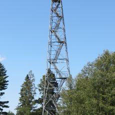
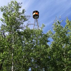
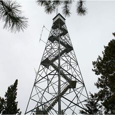
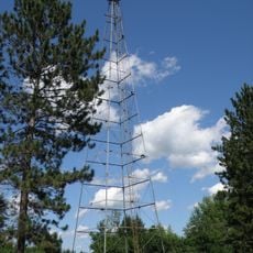
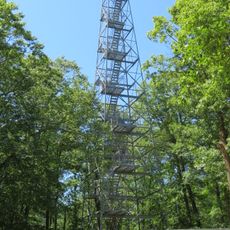
The forest is monitored using fire lookout towers and aircraft to detect wildfires early and prevent widespread damage. This surveillance becomes critical during dry periods when fire risk levels rise significantly across the woodland.

The community of curious travelers

AroundUs brings together thousands of curated places, local tips, and hidden gems, enriched daily by 60,000 contributors worldwide.

Start exploring
Location
GPS coordinates
46.73135,-94.84696
Latest update
December 14, 2025 13:02
Around this place
Itasca State Park
United States of America

Itasca State Park

62.9 km
Brainerd International Raceway
United States of America

Brainerd International Raceway

56.1 km
Crow Wing State Park
United States of America

Crow Wing State Park

64.5 km
Grand View Lodge
United States of America

Grand View Lodge

48.6 km
Minnesota State Sanatorium for Consumptives
United States of America

Minnesota State Sanatorium for Consumptives

43.2 km
Brainerd Water Tower
United States of America

Brainerd Water Tower

64.7 km
Old Wadena Historic District
United States of America

Old Wadena Historic District

34.5 km
Paul Bunyan State Forest
United States of America

Paul Bunyan State Forest

56.6 km
Crow Wing County Courthouse and Jail
United States of America

Crow Wing County Courthouse and Jail

64.6 km
Brainerd Public Library
United States of America

Brainerd Public Library

64.7 km
Badoura State Forest
United States of America

Badoura State Forest

15.8 km
Wilford H. Fawcett House
United States of America

Wilford H. Fawcett House

51.3 km
Finn Creek Museum
United States of America

Finn Creek Museum

48.2 km
Hewitt Public School
United States of America

Hewitt Public School

48.5 km
Nevis Tiger Muskie
United States of America

Nevis Tiger Muskie

26 km
Almond A. White House
United States of America

Almond A. White House

46.7 km
Parker Building
United States of America

Parker Building

64.9 km
Minnesota Highway 371 Bridge
United States of America

Minnesota Highway 371 Bridge

64.3 km
Trinity Lutheran Church
United States of America

Trinity Lutheran Church

64.7 km
Hubbard County Courthouse
United States of America

Hubbard County Courthouse

26.7 km
Cole Memorial Building
United States of America

Cole Memorial Building

43.1 km
Washington Street Bridge
United States of America

Washington Street Bridge

64 km
Smoky Hills State Forest
United States of America

Smoky Hills State Forest

47.7 km
Pequot Fire Lookout Tower
United States of America

Pequot Fire Lookout Tower

44.3 km
Nimrod Fire Tower
United States of America

Nimrod Fire Tower

9.1 km
Leisure Suites
United States of America

Leisure Suites

50.4 km
Aiton Heights Fire Tower
United States of America

Aiton Heights Fire Tower

56.9 km
Badoura Lookout Tower
United States of America

Badoura Lookout Tower

17.2 km
Show the full map
Reviews
Share your experience

No review yet

Discussions
Start a discussion...

No discussion yet

« Huntersville State Forest - State forest in Wadena County, United States » is provided by Around Us (aroundus.com). Images and texts are derived from Wikimedia project under a Creative Commons license. You are allowed to copy, distribute, and modify copies of this page, under the conditions set by the license, as long as this note is clearly visible.

Discover hidden gems everywhere you go!

From secret cafés to breathtaking viewpoints, skip the crowded tourist spots and find places that match your style. Our app makes it easy with voice search, smart filtering, route optimization, and insider tips from travelers worldwide. Download now for the complete mobile experience.

Around Us App Screenshot

A unique approach to discovering new places

Le Figaro

All the places worth exploring

France Info

A tailor-made excursion in just a few clicks

20 Minutes

Around Us
Travel Guide & Maps
Download

Send to your phone

QR Code
1

Open the camera app on your mobile.

2

Point at the QR code with your camera. A notification will appear.

3

Tap the notification to open the link.