Enable Location

We need your location to show you interesting places around you

Discover nearby places

Find interesting locations and hidden gems around you

Precise directions

Get accurate directions and distances to places

Your location is never shared with other users. It's only used when you tap the location button.

Interstate 470 Bridge

Log in to your account

Start exploring — it's free

Trusted by 63,461 travelers worldwide

Continue with Google
Continue with Apple
or

We will send you a code to connect

By continuing, you accept our Terms and Conditions and our Privacy Policy

Check your inbox

We've sent a pincode in your inbox. Please enter the code below.

Interstate 470 Bridge
Discussion Reviews 1 Photos
3.2k Popularity

Interstate 470 Bridge, Highway bridge in Bellaire, West Virginia, United States.

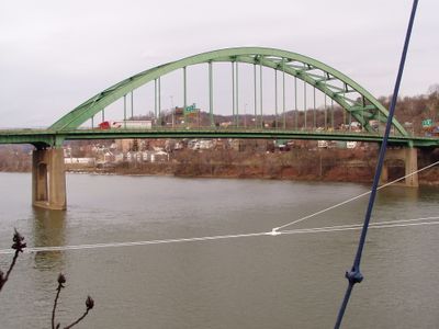
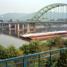
The Interstate 470 Bridge is a highway bridge crossing the Ohio River between Bellaire in West Virginia and Ohio. The structure uses a tied arch design with four lanes running about 70 feet (21 meters) above the water.

Construction began in 1975 to improve connections between Ohio and West Virginia. Technical difficulties with the cable systems caused delays before the bridge opened in the early 1980s.

The bridge carries the name Vietnam Veterans Memorial Bridge to honor military personnel who served during the Vietnam War. The name reflects how local communities remember and recognize service members through infrastructure.

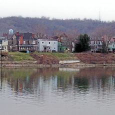
The bridge connects two states and handles significant daily traffic. Drivers should expect congestion during rush hours and proceed carefully if maintenance work is visible.

The bridge required specialized engineering to create its arch system, making it a notable achievement for its era. Engineers had to solve specific challenges posed by the river conditions and regional traffic needs.

The community of curious travelers

AroundUs brings together thousands of curated places, local tips, and hidden gems, enriched daily by 60,000 contributors worldwide.

Start exploring
Location
GPS coordinates
40.04980,-80.73070
Latest update
December 12, 2025 09:04
Around this place
Wheeling Suspension Bridge
United States of America

Wheeling Suspension Bridge

2.3 km
Wheeling Island
United States of America

Wheeling Island

2.3 km
Capitol Theatre
United States of America

Capitol Theatre

2.3 km
Wheeling Island Stadium
United States of America

Wheeling Island Stadium

1.6 km
Fort Henry Bridge
United States of America

Fort Henry Bridge

2.5 km
West Virginia Independence Hall
United States of America

West Virginia Independence Hall

1.8 km
Cathedral of Saint Joseph
United States of America

Cathedral of Saint Joseph

2.1 km
Bridgeport Bridge
United States of America

Bridgeport Bridge

2.6 km
L. S. Good House
United States of America

L. S. Good House

2.2 km
Center Wheeling Market
United States of America

Center Wheeling Market

1.2 km
Wheeling Island Historic District
United States of America

Wheeling Island Historic District

2.4 km
Chapline Street Row Historic District
United States of America

Chapline Street Row Historic District

1.3 km
Victoria Theater
United States of America

Victoria Theater

2 km
Federal Building and United States Courthouse
United States of America

Federal Building and United States Courthouse

2.2 km
Centre Market Square Historic District
United States of America

Centre Market Square Historic District

1.3 km
Belleview Heights
United States of America

Belleview Heights

2.7 km
East Wheeling Historic District
United States of America

East Wheeling Historic District

2.2 km
John McLure House
United States of America

John McLure House

2.1 km
Henry K. List House
United States of America

Henry K. List House

2.6 km
Joseph Kirkwood House
United States of America

Joseph Kirkwood House

2.4 km
Harry C. and Jessie F. Franzheim House
United States of America

Harry C. and Jessie F. Franzheim House

1.9 km
Robert W. Hazlett House
United States of America

Robert W. Hazlett House

1.5 km
Lang-Hess House
United States of America

Lang-Hess House

2.1 km
Robert C. Woods House
United States of America

Robert C. Woods House

2.4 km
Monroe Street East Historic District
United States of America

Monroe Street East Historic District

2.5 km
Riverside Iron Works Office Building
United States of America

Riverside Iron Works Office Building

1.7 km
Charles W. Russell House
United States of America

Charles W. Russell House

2.1 km
La Belle Iron Works
United States of America

La Belle Iron Works

726 m
Show the full map
Reviews
Share your experience

No review yet

Discussions
Start a discussion...

No discussion yet

« Interstate 470 Bridge - Highway bridge in Bellaire, West Virginia, United States » is provided by Around Us (aroundus.com). Images and texts are derived from Wikimedia project under a Creative Commons license. You are allowed to copy, distribute, and modify copies of this page, under the conditions set by the license, as long as this note is clearly visible.

Discover hidden gems everywhere you go!

From secret cafés to breathtaking viewpoints, skip the crowded tourist spots and find places that match your style. Our app makes it easy with voice search, smart filtering, route optimization, and insider tips from travelers worldwide. Download now for the complete mobile experience.

Around Us App Screenshot

A unique approach to discovering new places

Le Figaro

All the places worth exploring

France Info

A tailor-made excursion in just a few clicks

20 Minutes

Around Us
Travel Guide & Maps
Download

Send to your phone

QR Code
1

Open the camera app on your mobile.

2

Point at the QR code with your camera. A notification will appear.

3

Tap the notification to open the link.