Enable Location

We need your location to show you interesting places around you

Discover nearby places

Find interesting locations and hidden gems around you

Precise directions

Get accurate directions and distances to places

Your location is never shared with other users. It's only used when you tap the location button.

Log in to your account

Start exploring — it's free

Trusted by 67,733 travelers worldwide

Continue with Google
Continue with Apple
or

We will send you a code to connect

By continuing, you accept our Terms and Conditions and our Privacy Policy

Check your inbox

We've sent a pincode in your inbox. Please enter the code below.

Jeffries Projects
Discussion Reviews Photo
3.4k Popularity

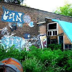
Jeffries Projects, Public housing complex near Lodge Freeway in Detroit, Michigan.

Jeffries Projects was a public housing complex in Detroit, Michigan, made up of thirteen high-rise towers and several rows of smaller houses. The development was designed to house families across a wide range of sizes, and it covered a large portion of the near west side of the city.

The complex was built in two phases between 1953 and 1955 and named after Edward J. Jeffries Sr., a Detroit judge whose son later served as the city's mayor. From the 1990s onward, the towers were torn down one by one as the city moved toward replacing large public housing blocks with smaller mixed-income developments.

For decades, the site was home to thousands of Detroit families who built close-knit communities within the towers and row houses. That sense of neighborhood belonging shaped how many former residents still talk about the place today.

The site sits on the near west side of Detroit and is best visited during the day, when the surrounding streets are easier to navigate. The original towers are gone, so there is nothing to enter, but the newer residential developments are visible from the street.

The Cornerstone development, completed in 2012, set aside rental housing in the form of townhouses and duplexes specifically for people who had previously lived on the site. This meant that many former residents could return to the same land rather than being displaced permanently.

The community of curious travelers

AroundUs brings together thousands of curated places, local tips, and hidden gems, enriched daily by 60,000 contributors worldwide.

Start exploring
Location
GPS coordinates
42.34153,-83.06742
Latest update
March 3, 2026 13:57
Around this place
Tiger Stadium
United States of America

Tiger Stadium

1.1 km
Detroit Masonic Temple
United States of America

Detroit Masonic Temple

598 m
MGM Grand Detroit
United States of America

MGM Grand Detroit

1.1 km
Trumbullplex
United States of America

Trumbullplex

882 m
Orchestra Hall
United States of America

Orchestra Hall

1 km
DTE Energy Headquarters
United States of America

DTE Energy Headquarters

1.2 km
Bonstelle Theatre
United States of America

Bonstelle Theatre

1 km
Eighth Precinct Police Station
United States of America

Eighth Precinct Police Station

1.1 km
Metropolitan Center for High Technology
United States of America

Metropolitan Center for High Technology

481 m
Film Exchange Building
United States of America

Film Exchange Building

1 km
Detroit-Columbia Central Office Building
United States of America

Detroit-Columbia Central Office Building

1 km
Jefferson Intermediate School
United States of America

Jefferson Intermediate School

580 m
First Unitarian Church of Detroit
United States of America

First Unitarian Church of Detroit

1 km
Coronado Apartments
United States of America

Coronado Apartments

651 m
St. Boniface Roman Catholic Church
United States of America

St. Boniface Roman Catholic Church

1.1 km
Elisha Taylor House
United States of America

Elisha Taylor House

1.1 km
Chapel of St. Theresa-the Little Flower
United States of America

Chapel of St. Theresa-the Little Flower

973 m
Hunter House
United States of America

Hunter House

769 m
Hudson-Evans House
United States of America

Hudson-Evans House

1.2 km
Clay Office and Conference Center
United States of America

Clay Office and Conference Center

611 m
Saints Peter and Paul Academy
United States of America

Saints Peter and Paul Academy

959 m
Architects Building
United States of America

Architects Building

728 m
Professional Plaza Tower
United States of America

Professional Plaza Tower

1.1 km
Robert M. and Matilda Grindley House
United States of America

Robert M. and Matilda Grindley House

858 m
Checker Cab Building
United States of America

Checker Cab Building

1 km
League of Catholic Women Building
United States of America

League of Catholic Women Building

854 m
Stuber-Stone Building
United States of America

Stuber-Stone Building

1.1 km
Woodward Avenue Baptist Church
United States of America

Woodward Avenue Baptist Church

1.2 km
Show the full map
Reviews
Share your experience

No review yet

Discussions
Start a discussion...

No discussion yet

« Jeffries Projects - Public housing complex near Lodge Freeway in Detroit, Michigan » is provided by Around Us (aroundus.com). Images and texts are derived from Wikimedia project under a Creative Commons license. You are allowed to copy, distribute, and modify copies of this page, under the conditions set by the license, as long as this note is clearly visible.

Discover hidden gems everywhere you go!

From secret cafés to breathtaking viewpoints, skip the crowded tourist spots and find places that match your style. Our app makes it easy with voice search, smart filtering, route optimization, and insider tips from travelers worldwide. Download now for the complete mobile experience.

Around Us App Screenshot

A unique approach to discovering new places

Le Figaro

All the places worth exploring

France Info

A tailor-made excursion in just a few clicks

20 Minutes

Around Us
Travel Guide & Maps
Download

Send to your phone

QR Code
1

Open the camera app on your mobile.

2

Point at the QR code with your camera. A notification will appear.

3

Tap the notification to open the link.