Enable Location

We need your location to show you interesting places around you

Discover nearby places

Find interesting locations and hidden gems around you

Precise directions

Get accurate directions and distances to places

Your location is never shared with other users. It's only used when you tap the location button.

Lake Willoughby

Log in to your account

Start exploring — it's free

Trusted by 61,876 travelers worldwide

Continue with Google
Continue with Apple
or

We will send you a code to connect

By continuing, you accept our Terms and Conditions and our Privacy Policy

Check your inbox

We've sent a pincode in your inbox. Please enter the code below.

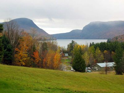
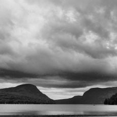
Lake Willoughby, Glacial lake in Westmore, Vermont, US

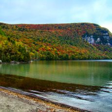
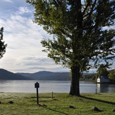
Lake Willoughby is a glacial lake situated between Mount Pisgah and Mount Hor, creating a deep valley formation called Willoughby Gap. The water body stretches approximately five miles through this landscape in Vermont's Northeast Kingdom.

Steamboats operated on the lake starting in the late 1800s, providing people with transportation and recreational opportunities. This era came to an end in the early 1900s when motorized vessels replaced them.

Devil's Rock on the Mount Pisgah side serves as a recognizable diving spot where people gather. The painted image on the rock has made it a landmark that marks a specific part of the shoreline for visitors.

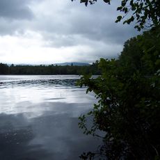
The lake has two public beaches where visitors can swim and enjoy the water. The north shore is near the outlet, while the south shore offers a different experience and attracts different types of visitors.

The lake reaches depths of around 100 meters, making it Vermont's deepest body of water and one of the most substantial in New England. This depth creates special conditions for diving that set it apart from most other lakes in the region.

The community of curious travelers

AroundUs brings together thousands of curated places, local tips, and hidden gems, enriched daily by 60,000 contributors worldwide.

Start exploring
Location
Elevation above the sea
356 m
GPS coordinates
44.75194,-72.06278
Latest update
December 6, 2025 19:04
Hidden places in Vermont: granite quarries, covered bridges, historic villages

Vermont hides historic places away from main roads, often forgotten by hurried travelers. Here you find granite quarries still working or long abandoned, small rural schools from the 1800s where children learned together, wooden covered bridges, and waterfalls flowing through thick forests. Trails...

Around this place
Bread and Puppet Theater
United States of America

Bread and Puppet Theater

11.8 km
Old Stone House Museum
United States of America

Old Stone House Museum

12.4 km
Mount Hor
United States of America

Mount Hor

4.4 km
Willoughby State Forest
United States of America

Willoughby State Forest

4.1 km
Brighton State Park
United States of America

Brighton State Park

17.2 km
St. Mary Star of the Sea
United States of America

St. Mary Star of the Sea

23.3 km
Brownington Village Historic District
United States of America

Brownington Village Historic District

12.6 km
Crystal Lake State Park
United States of America

Crystal Lake State Park

8.6 km
Goodrich Memorial Library
United States of America

Goodrich Memorial Library

23.6 km
Sentinel Rock State Park
United States of America

Sentinel Rock State Park

5.2 km
Burklyn Hall
United States of America

Burklyn Hall

20.2 km
Fox Hall
United States of America

Fox Hall

2.5 km
Darling Estate Historic District
United States of America

Darling Estate Historic District

20.2 km
Centre Covered Bridge
United States of America

Centre Covered Bridge

23.6 km
Orne Covered Bridge
United States of America

Orne Covered Bridge

20.6 km
Toll House
United States of America

Toll House

21.7 km
Bradley Covered Bridge
United States of America

Bradley Covered Bridge

23.7 km
Crystal Lake Falls Historic District
United States of America

Crystal Lake Falls Historic District

9 km
Newport Downtown Historic District
United States of America

Newport Downtown Historic District

23.7 km
United States Courthouse, Post Office and Customs House
United States of America

United States Courthouse, Post Office and Customs House

23.3 km
Union Meeting House
United States of America

Union Meeting House

17 km
L. P. Jenne Block
United States of America

L. P. Jenne Block

22.5 km
Burrington Covered Bridge
United States of America

Burrington Covered Bridge

23.3 km
King Block
United States of America

King Block

9 km
Island Pond Historic District
United States of America

Island Pond Historic District

16 km
Wheelock Common Historic District
United States of America

Wheelock Common Historic District

18.3 km
Bread & Puppet Theatre
United States of America

Bread & Puppet Theatre

11.8 km
Barton River Marsh
United States of America

Barton River Marsh

19.9 km
Show the full map
« Lake Willoughby - Glacial lake in Westmore, Vermont, US » is provided by Around Us (aroundus.com). Images and texts are derived from Wikimedia project under a Creative Commons license. You are allowed to copy, distribute, and modify copies of this page, under the conditions set by the license, as long as this note is clearly visible.

Discover hidden gems everywhere you go!

From secret cafés to breathtaking viewpoints, skip the crowded tourist spots and find places that match your style. Our app makes it easy with voice search, smart filtering, route optimization, and insider tips from travelers worldwide. Download now for the complete mobile experience.

Around Us App Screenshot

A unique approach to discovering new places

Le Figaro

All the places worth exploring

France Info

A tailor-made excursion in just a few clicks

20 Minutes

Around Us
Travel Guide & Maps
Download

Send to your phone

QR Code
1

Open the camera app on your mobile.

2

Point at the QR code with your camera. A notification will appear.

3

Tap the notification to open the link.