Enable Location

We need your location to show you interesting places around you

Discover nearby places

Find interesting locations and hidden gems around you

Precise directions

Get accurate directions and distances to places

Your location is never shared with other users. It's only used when you tap the location button.

Willoughby State Forest

Log in to your account

Start exploring — it's free

Trusted by 63,011 travelers worldwide

Continue with Google
Continue with Apple
or

We will send you a code to connect

By continuing, you accept our Terms and Conditions and our Privacy Policy

Check your inbox

We've sent a pincode in your inbox. Please enter the code below.

Willoughby State Forest
Discussion Reviews 1 Photos
1.9k Popularity

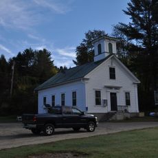
Willoughby State Forest, State forest in Caledonia County, Vermont.

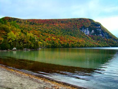
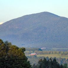
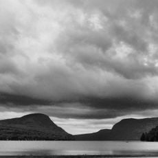
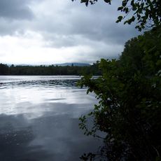
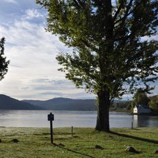
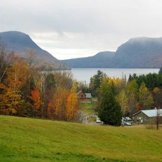
Willoughby State Forest is a large woodland area with multiple hiking routes and natural features including a substantial lake and steep mountainsides. The space combines forested slopes, open water, and rocky terrain that create varied landscapes for exploring.

The state established this forest area in the late 1920s as a protected woodland to preserve natural resources and provide recreation opportunities. This protection decision marked an early effort to set aside land for public use and environmental conservation.

The forest serves as a place where visitors come to connect with Vermont's natural environment and learn about the animals and plants that live here. People use the trails and lakeside areas to spend time outdoors and experience the rhythm of the seasons in this landscape.

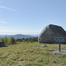
The forest has marked trails of varying difficulty that start from different entry points and lead through different parts of the landscape. Parking areas are located at the main access points, making it easy to reach the trail network from different starting locations.

The forest protects two distinct natural areas with specialized ecosystems that show the range of environments found in this region. These protected zones reveal how varied the habitats can be within a single woodland property.

The community of curious travelers

AroundUs brings together thousands of curated places, local tips, and hidden gems, enriched daily by 60,000 contributors worldwide.

Start exploring
Location
Inception
1928
GPS coordinates
44.71529,-72.06280
Latest update
December 14, 2025 11:02
Around this place
Bread and Puppet Theater
United States of America

Bread and Puppet Theater

9.8 km
Burke Mountain
United States of America

Burke Mountain

21 km
Old Stone House Museum
United States of America

Old Stone House Museum

15.7 km
Mount Hor
United States of America

Mount Hor

792 m
Brighton State Park
United States of America

Brighton State Park

18.8 km
Brownington Village Historic District
United States of America

Brownington Village Historic District

15.9 km
Crystal Lake State Park
United States of America

Crystal Lake State Park

9.2 km
Sentinel Rock State Park
United States of America

Sentinel Rock State Park

9 km
Burklyn Hall
United States of America

Burklyn Hall

16.5 km
Fox Hall
United States of America

Fox Hall

6.5 km
Darling Estate Historic District
United States of America

Darling Estate Historic District

16.5 km
Chamberlin Mill Covered Bridge
United States of America

Chamberlin Mill Covered Bridge

22.6 km
Old Schoolhouse Bridge
United States of America

Old Schoolhouse Bridge

22.6 km
Centre Covered Bridge
United States of America

Centre Covered Bridge

19.7 km
Methodist Episcopal Church
United States of America

Methodist Episcopal Church

22.6 km
Toll House
United States of America

Toll House

18.5 km
Bradley Covered Bridge
United States of America

Bradley Covered Bridge

19.7 km
Crystal Lake Falls Historic District
United States of America

Crystal Lake Falls Historic District

9.6 km
Union Meeting House
United States of America

Union Meeting House

13.8 km
District 6 School House
United States of America

District 6 School House

19.8 km
Riverside
United States of America

Riverside

23.2 km
Burrington Covered Bridge
United States of America

Burrington Covered Bridge

19.4 km
King Block
United States of America

King Block

9.8 km
Island Pond Historic District
United States of America

Island Pond Historic District

18.2 km
Stannard Schoolhouse
United States of America

Stannard Schoolhouse

22.7 km
Wheelock Common Historic District
United States of America

Wheelock Common Historic District

14.3 km
Bread & Puppet Theatre
United States of America

Bread & Puppet Theatre

9.8 km
Lake Willoughby
United States of America

Lake Willoughby

4.1 km
Show the full map
Reviews
Share your experience

No review yet

Discussions
Start a discussion...

No discussion yet

« Willoughby State Forest - State forest in Caledonia County, Vermont » is provided by Around Us (aroundus.com). Images and texts are derived from Wikimedia project under a Creative Commons license. You are allowed to copy, distribute, and modify copies of this page, under the conditions set by the license, as long as this note is clearly visible.

Discover hidden gems everywhere you go!

From secret cafés to breathtaking viewpoints, skip the crowded tourist spots and find places that match your style. Our app makes it easy with voice search, smart filtering, route optimization, and insider tips from travelers worldwide. Download now for the complete mobile experience.

Around Us App Screenshot

A unique approach to discovering new places

Le Figaro

All the places worth exploring

France Info

A tailor-made excursion in just a few clicks

20 Minutes

Around Us
Travel Guide & Maps
Download

Send to your phone

QR Code
1

Open the camera app on your mobile.

2

Point at the QR code with your camera. A notification will appear.

3

Tap the notification to open the link.