Enable Location

We need your location to show you interesting places around you

Discover nearby places

Find interesting locations and hidden gems around you

Precise directions

Get accurate directions and distances to places

Your location is never shared with other users. It's only used when you tap the location button.

Mason School

Log in to your account

Start exploring — it's free

Trusted by 62,457 travelers worldwide

Continue with Google
Continue with Apple
or

We will send you a code to connect

By continuing, you accept our Terms and Conditions and our Privacy Policy

Check your inbox

We've sent a pincode in your inbox. Please enter the code below.

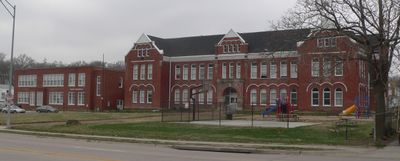
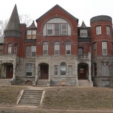
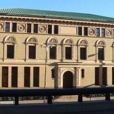
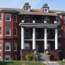
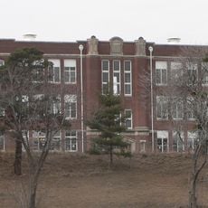
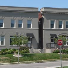
Mason School, School building in south Omaha, Nebraska.

Mason School at South 24th Street in south Omaha features Richardson Romanesque design with red brick walls, arched windows, and ornamental stonework across its two main levels. The building was later converted into residential apartments while preserving its original architectural character.

The building was constructed in 1888 following designs by architects Hadden, Rocheford & Gould and named after Nebraska Supreme Court Justice Charles Mason. It expanded several times over the following decades to accommodate growing enrollment before receiving a major brick addition in 1936.

This school served as a gathering place for families in the south Omaha neighborhood, welcoming children from immigrant communities who settled in the area.

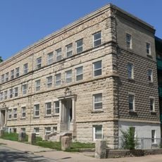
The building stands in an accessible residential neighborhood in south Omaha with easy street access for viewing its exterior. Visitors should note that the interior is not publicly accessible since it now serves as private residential apartments.

Before a permanent brick structure was added, temporary wooden expansions were the only way to fit the rapidly growing student body into available classrooms. This hands-on approach reveals how quickly the neighborhood was changing during that era.

The community of curious travelers

AroundUs brings together thousands of curated places, local tips, and hidden gems, enriched daily by 60,000 contributors worldwide.

Start exploring
Location
GPS coordinates
41.25021,-95.94789
Latest update
December 14, 2025 18:11
Around this place
AT&T Building
United States of America

AT&T Building

1.1 km
Omaha Children's Museum
United States of America

Omaha Children's Museum

668 m
Douglas County Courthouse
United States of America

Douglas County Courthouse

1 km
Rose Blumkin Performing Arts Center
United States of America

Rose Blumkin Performing Arts Center

901 m
Woodmen of the World Building
United States of America

Woodmen of the World Building

1.1 km
Omaha Quartermaster Depot Historic District
United States of America

Omaha Quartermaster Depot Historic District

763 m
Georgia Row House
United States of America

Georgia Row House

591 m
Elsasser Bakery
United States of America

Elsasser Bakery

1.1 km
Omaha Public Library
United States of America

Omaha Public Library

916 m
Federal Office Building
United States of America

Federal Office Building

1.1 km
Bee Building
United States of America

Bee Building

1.1 km
Drake Court Historic District
United States of America

Drake Court Historic District

491 m
Hill Hotel
United States of America

Hill Hotel

1.1 km
Normandie Apartments
United States of America

Normandie Apartments

686 m
Mary Rogers Kimball House
United States of America

Mary Rogers Kimball House

482 m
Howard Street Apartment District
United States of America

Howard Street Apartment District

660 m
Leone, Florentine and Carpathia Apartment Buildings
United States of America

Leone, Florentine and Carpathia Apartment Buildings

112 m
Park School
United States of America

Park School

745 m
Scoular Building
United States of America

Scoular Building

1.1 km
Ansonia Apartments
United States of America

Ansonia Apartments

491 m
Eggerss–O'Flyng Building
United States of America

Eggerss–O'Flyng Building

1.1 km
United States of America

Berkeley Apartments

650 m
Selma Terrace
United States of America

Selma Terrace

736 m
Undine Apartments
United States of America

Undine Apartments

673 m
Moyer Row Houses
United States of America

Moyer Row Houses

664 m
Northern Natural Gas Building
United States of America

Northern Natural Gas Building

1 km
Gallery 1516
United States of America

Gallery 1516

982 m
Westbrook Tower
United States of America

Westbrook Tower

939 m
Show the full map
« Mason School - School building in south Omaha, Nebraska » is provided by Around Us (aroundus.com). Images and texts are derived from Wikimedia project under a Creative Commons license. You are allowed to copy, distribute, and modify copies of this page, under the conditions set by the license, as long as this note is clearly visible.

Discover hidden gems everywhere you go!

From secret cafés to breathtaking viewpoints, skip the crowded tourist spots and find places that match your style. Our app makes it easy with voice search, smart filtering, route optimization, and insider tips from travelers worldwide. Download now for the complete mobile experience.

Around Us App Screenshot

A unique approach to discovering new places

Le Figaro

All the places worth exploring

France Info

A tailor-made excursion in just a few clicks

20 Minutes

Around Us
Travel Guide & Maps
Download

Send to your phone

QR Code
1

Open the camera app on your mobile.

2

Point at the QR code with your camera. A notification will appear.

3

Tap the notification to open the link.