Enable Location

We need your location to show you interesting places around you

Discover nearby places

Find interesting locations and hidden gems around you

Precise directions

Get accurate directions and distances to places

Your location is never shared with other users. It's only used when you tap the location button.

Omaha Quartermaster Depot Historic District

Log in to your account

Start exploring — it's free

Trusted by 62,443 travelers worldwide

Continue with Google
Continue with Apple
or

We will send you a code to connect

By continuing, you accept our Terms and Conditions and our Privacy Policy

Check your inbox

We've sent a pincode in your inbox. Please enter the code below.

Omaha Quartermaster Depot Historic District

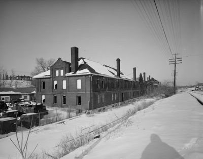
Omaha Quartermaster Depot Historic District, Military supply depot in South Omaha, United States.

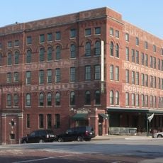
Omaha Quartermaster Depot Historic District is a military supply facility in South Omaha with multiple brick structures built between 1881 and 1894. The buildings sit along the Union Pacific Railroad main line and include warehouses, administrative facilities, and service buildings from the original construction period.

The depot was established in 1881 to supply military camps and National Guard units throughout the Midwest region. During the Great Depression, it transitioned to serve as a civilian work corps base before taking on additional roles in later decades.

The site served as a supply and logistics hub that shaped military operations across the Midwest for decades. Visitors can observe how the buildings reflect the practical needs of different organizations that operated here over time.

The district is located between Hickory and 22nd Streets with the Union Pacific Railroad forming the eastern boundary. The preserved buildings are open for viewing, and visitors can walk through the site to see the various structures and their layout.

One of the warehouses housed Italian prisoners of war at the end of World War II, a detail many visitors overlook. This temporary occupation reflects how the site adapted to wartime needs beyond its original supply mission.

The community of curious travelers

AroundUs brings together thousands of curated places, local tips, and hidden gems, enriched daily by 60,000 contributors worldwide.

Start exploring
Location
GPS coordinates
41.24429,-95.94329
Latest update
December 13, 2025 11:47
Around this place
Sokol Auditorium
United States of America

Sokol Auditorium

1 km
Gerald R. Ford Birthsite and Gardens
United States of America

Gerald R. Ford Birthsite and Gardens

1.4 km
Omaha Children's Museum
United States of America

Omaha Children's Museum

1.2 km
Joel N. Cornish House
United States of America

Joel N. Cornish House

1.1 km
St. Frances Cabrini Catholic Church
United States of America

St. Frances Cabrini Catholic Church

1.2 km
Boulevards in Omaha, Nebraska
United States of America

Boulevards in Omaha, Nebraska

1.3 km
Georgia Row House
United States of America

Georgia Row House

1.1 km
Elsasser Bakery
United States of America

Elsasser Bakery

649 m
Immaculate Conception Church and School
United States of America

Immaculate Conception Church and School

1.2 km
Omaha Public Library
United States of America

Omaha Public Library

1.4 km
Federal Office Building
United States of America

Federal Office Building

1.3 km
St. Joseph Parish Complex
United States of America

St. Joseph Parish Complex

510 m
Vinton Street Commercial Historic District
United States of America

Vinton Street Commercial Historic District

1.3 km
Drake Court Historic District
United States of America

Drake Court Historic District

992 m
Mason School
United States of America

Mason School

763 m
Hill Hotel
United States of America

Hill Hotel

1.3 km
Normandie Apartments
United States of America

Normandie Apartments

1.2 km
Mary Rogers Kimball House
United States of America

Mary Rogers Kimball House

1.1 km
Howard Street Apartment District
United States of America

Howard Street Apartment District

1.3 km
Bishop Worthington Residence
United States of America

Bishop Worthington Residence

1.1 km
Leone, Florentine and Carpathia Apartment Buildings
United States of America

Leone, Florentine and Carpathia Apartment Buildings

868 m
Park School
United States of America

Park School

982 m
Ansonia Apartments
United States of America

Ansonia Apartments

992 m
Eggerss–O'Flyng Building
United States of America

Eggerss–O'Flyng Building

1.1 km
United States of America

Berkeley Apartments

993 m
Moyer Row Houses
United States of America

Moyer Row Houses

1.4 km
Gallery 1516
United States of America

Gallery 1516

1.1 km
City National Bank Building and Creighton Orpheum Theater
United States of America

City National Bank Building and Creighton Orpheum Theater

1.4 km
Show the full map
« Omaha Quartermaster Depot Historic District - Military supply depot in South Omaha, United States » is provided by Around Us (aroundus.com). Images and texts are derived from Wikimedia project under a Creative Commons license. You are allowed to copy, distribute, and modify copies of this page, under the conditions set by the license, as long as this note is clearly visible.

Discover hidden gems everywhere you go!

From secret cafés to breathtaking viewpoints, skip the crowded tourist spots and find places that match your style. Our app makes it easy with voice search, smart filtering, route optimization, and insider tips from travelers worldwide. Download now for the complete mobile experience.

Around Us App Screenshot

A unique approach to discovering new places

Le Figaro

All the places worth exploring

France Info

A tailor-made excursion in just a few clicks

20 Minutes

Around Us
Travel Guide & Maps
Download

Send to your phone

QR Code
1

Open the camera app on your mobile.

2

Point at the QR code with your camera. A notification will appear.

3

Tap the notification to open the link.