Enable Location

We need your location to show you interesting places around you

Discover nearby places

Find interesting locations and hidden gems around you

Precise directions

Get accurate directions and distances to places

Your location is never shared with other users. It's only used when you tap the location button.

Mattabesett Trail

Log in to your account

Start exploring — it's free

Trusted by 62,534 travelers worldwide

Continue with Google
Continue with Apple
or

We will send you a code to connect

By continuing, you accept our Terms and Conditions and our Privacy Policy

Check your inbox

We've sent a pincode in your inbox. Please enter the code below.

Mattabesett Trail

Mattabesett Trail, Weg in den Vereinigten Staaten

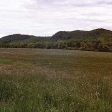
The Mattabesett Trail is a hiking path spanning roughly 75 miles through Connecticut in a horseshoe loop shape, passing through nine towns from Middletown to Berlin. The route follows rocky ridge walks with cliff views, crosses traprock formations, passes mountains like Pisgah and Beseck, and winds through forests with streams, wetlands, and spring pools.

The trail is part of the New England National Scenic Trail network, officially recognized in 2009, which extends over 200 miles from Long Island Sound into New Hampshire. It was developed by early Connecticut hiking enthusiasts and passes through areas marked by early settlement remnants, with much of the surrounding forest purchased in 1945 as Cookaponset State Forest.

The trail winds through multiple towns and passes by remnants of early settlement sites, connecting local communities with their natural surroundings. Hikers use this path to experience the woodland character that defines much of Connecticut's landscape.

The path is mostly packed earth and dirt with rocky sections and rock scrambles suitable for moderate to advanced hikers. Carry a map or guide, wear sturdy footwear, and wear bright orange clothing during hunting season to stay visible and safe.

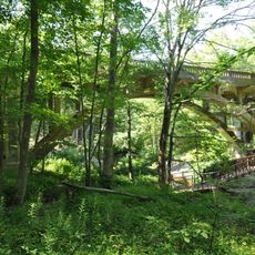
An old well and homestead foundation remnants line the eastern section, likely dating to early Middletown settlement, offering hikers a glimpse of the area's past. These quiet discoveries along the trail add a layer of historical connection to the woodland walk.

The community of curious travelers

AroundUs brings together thousands of curated places, local tips, and hidden gems, enriched daily by 60,000 contributors worldwide.

Start exploring
Location
GPS coordinates
41.43680,-72.68040
Latest update
February 7, 2026 11:01
Around this place
Wadsworth Falls State Park
United States of America

Wadsworth Falls State Park

11 km
Chatfield Hollow State Park
United States of America

Chatfield Hollow State Park

10 km
Wadsworth Mansion at Long Hill
United States of America

Wadsworth Mansion at Long Hill

11.6 km
Millers Pond State Park
United States of America

Millers Pond State Park

5.9 km
Northford Center Historic District
United States of America

Northford Center Historic District

9.5 km
Nehemiah Royce House
United States of America

Nehemiah Royce House

11.6 km
Paul Mellon Arts Center
United States of America

Paul Mellon Arts Center

11 km
Trimountain
United States of America

Trimountain

5.3 km
Pistapaug Mountain
United States of America

Pistapaug Mountain

4.8 km
Fowler Mountain
United States of America

Fowler Mountain

5.1 km
Tri-Mountain State Park
United States of America

Tri-Mountain State Park

5.2 km
United States of America

Higganum Reservoir State Park

11.5 km
Main Street Historic District
United States of America

Main Street Historic District

4.1 km
William Ward Jr. House
United States of America

William Ward Jr. House

8.6 km
Nehemiah Hubbard House
United States of America

Nehemiah Hubbard House

11.3 km
Oak Lodge
United States of America

Oak Lodge

10.6 km
David Lyman II House
United States of America

David Lyman II House

7.1 km
Bridge No. 1132
United States of America

Bridge No. 1132

10.5 km
Thomas Lyman House
United States of America

Thomas Lyman House

5.3 km
Kohler Environmental Center
United States of America

Kohler Environmental Center

10.1 km
Higganum Landing Historic District
United States of America

Higganum Landing Historic District

11.1 km
Meeting House Hill Historic District
United States of America

Meeting House Hill Historic District

8.6 km
Parmelee House
United States of America

Parmelee House

9.8 km
Howd-Linsley House
United States of America

Howd-Linsley House

7.9 km
Joseph Blakeslee House
United States of America

Joseph Blakeslee House

8.7 km
Fourth District School
United States of America

Fourth District School

10.4 km
Warham Williams House
United States of America

Warham Williams House

10.5 km
Dudley Farm
United States of America

Dudley Farm

9.7 km
Show the full map
« Mattabesett Trail - Weg in den Vereinigten Staaten » is provided by Around Us (aroundus.com). Images and texts are derived from Wikimedia project under a Creative Commons license. You are allowed to copy, distribute, and modify copies of this page, under the conditions set by the license, as long as this note is clearly visible.

Discover hidden gems everywhere you go!

From secret cafés to breathtaking viewpoints, skip the crowded tourist spots and find places that match your style. Our app makes it easy with voice search, smart filtering, route optimization, and insider tips from travelers worldwide. Download now for the complete mobile experience.

Around Us App Screenshot

A unique approach to discovering new places

Le Figaro

All the places worth exploring

France Info

A tailor-made excursion in just a few clicks

20 Minutes

Around Us
Travel Guide & Maps
Download

Send to your phone

QR Code
1

Open the camera app on your mobile.

2

Point at the QR code with your camera. A notification will appear.

3

Tap the notification to open the link.