Enable Location

We need your location to show you interesting places around you

Discover nearby places

Find interesting locations and hidden gems around you

Precise directions

Get accurate directions and distances to places

Your location is never shared with other users. It's only used when you tap the location button.

Merrill Creek Reservoir

Log in to your account

Start exploring — it's free

Trusted by 62,351 travelers worldwide

Continue with Google
Continue with Apple
or

We will send you a code to connect

By continuing, you accept our Terms and Conditions and our Privacy Policy

Check your inbox

We've sent a pincode in your inbox. Please enter the code below.

Merrill Creek Reservoir

Merrill Creek Reservoir, lake in New Jersey, United States

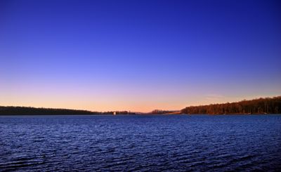
Merrill Creek Reservoir is a 650-acre manmade lake in northwestern New Jersey surrounded by woodlands and open fields. The water body is lined with hiking trails and serves as a water storage facility that helps maintain river flow downstream.

The reservoir was constructed in the 1980s to store water and help maintain Delaware River flow during dry periods. The project resulted from collaboration between utility companies and the region to manage water resources effectively.

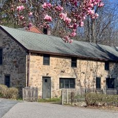
The reservoir takes its name from a historic mill that once operated in this area during early settlement. Today visitors experience it as a place for quiet walks and waterfowl observation, especially in winter when snow geese rest on the water.

The site is open daily from sunrise to sunset, with winter hours closing at 4:30 PM. Visitors should wear comfortable shoes, bring insect repellent and tick preventive, and disinfect their gear before visiting to help prevent disease spread among birds.

Scientists conduct bird banding operations here and attach transmitters to turtles to track their movements and guide conservation efforts. Visitors may sometimes see nets suspended from trees as part of this important research work.

The community of curious travelers

AroundUs brings together thousands of curated places, local tips, and hidden gems, enriched daily by 60,000 contributors worldwide.

Start exploring
Location
GPS coordinates
40.73610,-75.10140
Latest update
February 7, 2026 11:01
Around this place
Interstate 78 Toll Bridge
United States of America

Interstate 78 Toll Bridge

9.6 km
Easton–Phillipsburg Toll Bridge
United States of America

Easton–Phillipsburg Toll Bridge

9.8 km
Shippen Manor
United States of America

Shippen Manor

11.7 km
Riverton–Belvidere Bridge
United States of America

Riverton–Belvidere Bridge

10.4 km
College Hill Residential Historic District
United States of America

College Hill Residential Historic District

9.4 km
Oxford Furnace
United States of America

Oxford Furnace

11.5 km
Zeta Psi Fraternity House
United States of America

Zeta Psi Fraternity House

10 km
Asbury Historic District
United States of America

Asbury Historic District

8.5 km
New Hampton Pony Pratt Truss Bridge
United States of America

New Hampton Pony Pratt Truss Bridge

11.8 km
First Methodist Episcopal Church
United States of America

First Methodist Episcopal Church

10.8 km
St. James Lutheran Church
United States of America

St. James Lutheran Church

7.3 km
Warren County Courthouse
United States of America

Warren County Courthouse

10.4 km
Kennedy House and Mill
United States of America

Kennedy House and Mill

8.4 km
Imlaydale Historic District
United States of America

Imlaydale Historic District

11.5 km
Belvidere Historic District
United States of America

Belvidere Historic District

10.6 km
Phillipsburg Commercial Historic District
United States of America

Phillipsburg Commercial Historic District

9.9 km
Van Nest–Hoff–Vannatta Farmstead
United States of America

Van Nest–Hoff–Vannatta Farmstead

3.9 km
William Jacob Heller House
United States of America

William Jacob Heller House

9.2 km
New Hampton Historic District
United States of America

New Hampton Historic District

11.8 km
Lander–Stewart Mansion and Stites Building
United States of America

Lander–Stewart Mansion and Stites Building

9.9 km
Oxford Industrial Historic District
United States of America

Oxford Industrial Historic District

11.4 km
Hixson–Skinner Mill Complex
United States of America

Hixson–Skinner Mill Complex

9.6 km
Asbury United Methodist Church
United States of America

Asbury United Methodist Church

8.8 km
Northampton Street Bridge
United States of America

Northampton Street Bridge

10 km
John Roseberry Homestead
United States of America

John Roseberry Homestead

8.6 km
Green's Bridge
United States of America

Green's Bridge

8.8 km
Pleasant Valley Historic District
United States of America

Pleasant Valley Historic District

8.2 km
Bowerstown Historic District
United States of America

Bowerstown Historic District

9.6 km
Show the full map
« Merrill Creek Reservoir - lake in New Jersey, United States » is provided by Around Us (aroundus.com). Images and texts are derived from Wikimedia project under a Creative Commons license. You are allowed to copy, distribute, and modify copies of this page, under the conditions set by the license, as long as this note is clearly visible.

Discover hidden gems everywhere you go!

From secret cafés to breathtaking viewpoints, skip the crowded tourist spots and find places that match your style. Our app makes it easy with voice search, smart filtering, route optimization, and insider tips from travelers worldwide. Download now for the complete mobile experience.

Around Us App Screenshot

A unique approach to discovering new places

Le Figaro

All the places worth exploring

France Info

A tailor-made excursion in just a few clicks

20 Minutes

Around Us
Travel Guide & Maps
Download

Send to your phone

QR Code
1

Open the camera app on your mobile.

2

Point at the QR code with your camera. A notification will appear.

3

Tap the notification to open the link.