Enable Location

We need your location to show you interesting places around you

Discover nearby places

Find interesting locations and hidden gems around you

Precise directions

Get accurate directions and distances to places

Your location is never shared with other users. It's only used when you tap the location button.

Riverton–Belvidere Bridge

Log in to your account

Start exploring — it's free

Trusted by 62,348 travelers worldwide

Continue with Google
Continue with Apple
or

We will send you a code to connect

By continuing, you accept our Terms and Conditions and our Privacy Policy

Check your inbox

We've sent a pincode in your inbox. Please enter the code below.

Riverton–Belvidere Bridge

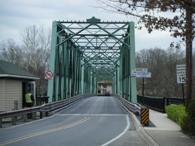
Riverton–Belvidere Bridge, Steel truss bridge across Delaware River between Belvidere, New Jersey and Riverton, Pennsylvania, United States.

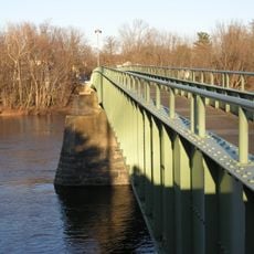
The Riverton-Belvidere Bridge is a steel truss structure crossing the Delaware River and connecting communities in New Jersey and Pennsylvania. It is composed of four spans arranged in a double Warren truss design with riveted steel construction.

A wooden covered bridge originally stood at this location until severe flooding destroyed it in October 1903. The steel replacement was completed the following year and has served as the crossing ever since.

The Delaware River Joint Toll Bridge Commission manages this passage between two states, maintaining its structural elements and monitoring traffic patterns.

The structure has narrow lane dimensions and strict speed limits along with weight restrictions for safety. Visitors should check local traffic information before crossing, as the narrow dimensions may affect passage of certain vehicles.

The structure incorporates 355 tons of steel supported by stone-filled piers and timber cribs, with concrete-filled steel sheet pilings for reinforcement.

The community of curious travelers

AroundUs brings together thousands of curated places, local tips, and hidden gems, enriched daily by 60,000 contributors worldwide.

Start exploring
Location
Location
Official opening
1904
GPS coordinates
40.82880,-75.08470
Latest update
December 13, 2025 17:01
Around this place
United States of America

Land of Make Believe

13.4 km
Paulinskill Viaduct
United States of America

Paulinskill Viaduct

13.4 km
Merrill Creek Reservoir
United States of America

Merrill Creek Reservoir

10.4 km
Delaware River Viaduct
United States of America

Delaware River Viaduct

12.2 km
Shippen Manor
United States of America

Shippen Manor

7.8 km
Weona Park Carousel
United States of America

Weona Park Carousel

14.6 km
Darlington's Bridge at Delaware Station
United States of America

Darlington's Bridge at Delaware Station

7.9 km
Portland–Columbia Pedestrian Bridge
United States of America

Portland–Columbia Pedestrian Bridge

10.7 km
Portland–Columbia Toll Bridge
United States of America

Portland–Columbia Toll Bridge

10.3 km
Oxford Furnace
United States of America

Oxford Furnace

7.8 km
Columcille Megalith Park
United States of America

Columcille Megalith Park

14.8 km
St. Luke's Episcopal Church
United States of America

St. Luke's Episcopal Church

13.3 km
United States of America

Danville Mountain

13.2 km
Port Murray Historic District
United States of America

Port Murray Historic District

14.9 km
Port Colden Historic District
United States of America

Port Colden Historic District

13 km
Real Estate Building
United States of America

Real Estate Building

11 km
First Methodist Episcopal Church
United States of America

First Methodist Episcopal Church

12 km
Warren County Courthouse
United States of America

Warren County Courthouse

715 m
Belvidere Historic District
United States of America

Belvidere Historic District

655 m
Bridge in Bangor Borough
United States of America

Bridge in Bangor Borough

11.3 km
Van Nest–Hoff–Vannatta Farmstead
United States of America

Van Nest–Hoff–Vannatta Farmstead

8.3 km
Warrington Stone Bridge
United States of America

Warrington Stone Bridge

11.6 km
County Bridge No. 36
United States of America

County Bridge No. 36

10.3 km
Oxford Industrial Historic District
United States of America

Oxford Industrial Historic District

8.3 km
Fairview Schoolhouse
United States of America

Fairview Schoolhouse

11.9 km
Moravian Cemetery
United States of America

Moravian Cemetery

13.2 km
Pleasant Valley Historic District
United States of America

Pleasant Valley Historic District

11.1 km
Bowerstown Historic District
United States of America

Bowerstown Historic District

9.6 km
Show the full map
« Riverton–Belvidere Bridge - Steel truss bridge across Delaware River between Belvidere, New Jersey and Riverton, Pennsylvania, United States » is provided by Around Us (aroundus.com). Images and texts are derived from Wikimedia project under a Creative Commons license. You are allowed to copy, distribute, and modify copies of this page, under the conditions set by the license, as long as this note is clearly visible.

Discover hidden gems everywhere you go!

From secret cafés to breathtaking viewpoints, skip the crowded tourist spots and find places that match your style. Our app makes it easy with voice search, smart filtering, route optimization, and insider tips from travelers worldwide. Download now for the complete mobile experience.

Around Us App Screenshot

A unique approach to discovering new places

Le Figaro

All the places worth exploring

France Info

A tailor-made excursion in just a few clicks

20 Minutes

Around Us
Travel Guide & Maps
Download

Send to your phone

QR Code
1

Open the camera app on your mobile.

2

Point at the QR code with your camera. A notification will appear.

3

Tap the notification to open the link.