Enable Location

We need your location to show you interesting places around you

Discover nearby places

Find interesting locations and hidden gems around you

Precise directions

Get accurate directions and distances to places

Your location is never shared with other users. It's only used when you tap the location button.

Darlington's Bridge at Delaware Station

Log in to your account

Join the adventure

Create your free account and start exploring (like 60k+ others)

We will send you a code to connect

or
Continue with Google
Continue with Apple
By continuing, you accept our Terms and Conditions and our Privacy Policy

Check your inbox

We've sent a pincode in your inbox. Please enter the code below.

Darlington's Bridge at Delaware Station

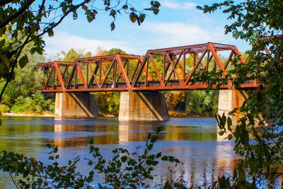
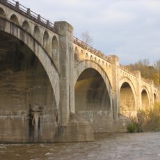
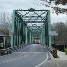
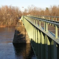
Darlington's Bridge at Delaware Station, Railway and road bridge in Upper Mount Bethel Township, US.

Description

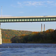
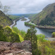
Darlington's Bridge is a two-level crossing over the Delaware River with rail tracks on the upper deck for trains and a roadway on the lower level for vehicles. The structure directly links Upper Mount Bethel Township in Pennsylvania with New Jersey and accommodates both types of traffic simultaneously.

History

The original wooden crossing was built in 1855 by the Delaware, Lackawanna and Western Railroad and replaced in 1871 with an iron truss bridge. This upgrade allowed heavier trains to cross and eventually enabled the roadway to be added for vehicle traffic.

Culture

The bridge became a vital crossing point where residents of Pennsylvania and New Jersey regularly moved goods and visited each other across state lines. This daily movement shaped how communities on both sides of the Delaware River developed and stayed connected.

Practical

The bridge operates during most daylight hours and carries both train and vehicle traffic regularly. Visitors should expect slower crossings during peak times and be aware that trains may pass with limited warning.

Did you know?

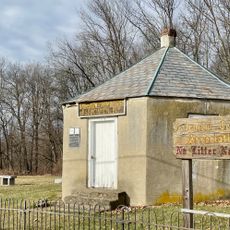
Edward McCracken and his wife once guarded toll collection with the help of their Airedale dogs, who were trained to protect the revenue from theft. This unusual security arrangement stayed in place until tolls were eliminated in the 1930s.

Official opening
December 19, 1914
GPS coordinates
40.89947,-75.07480
Latest update
December 14, 2025 09:46

AroundUs brings together thousands of curated places, local tips, and hidden gems, enriched daily by 60,000 contributors worldwide. Discover all places nearby (Upper Mount Bethel Township).

Around this place
Mount Tammany
United States of America

Mount Tammany

8.4 km
United States of America

Land of Make Believe

9.7 km
Jenny Jump State Forest
United States of America

Jenny Jump State Forest

12.8 km
Paulinskill Viaduct
United States of America

Paulinskill Viaduct

5.5 km
Sunfish Pond
United States of America

Sunfish Pond

11.5 km
Delaware Water Gap Toll Bridge
United States of America

Delaware Water Gap Toll Bridge

10 km
Delaware River Viaduct
United States of America

Delaware River Viaduct

5 km
Worthington State Forest
United States of America

Worthington State Forest

10.5 km
Mount Minsi
United States of America

Mount Minsi

8.1 km
Siddhachalam
United States of America

Siddhachalam

12 km
Shippen Manor
United States of America

Shippen Manor

12.3 km
Riverton–Belvidere Bridge
United States of America

Riverton–Belvidere Bridge

7.9 km
Portland–Columbia Pedestrian Bridge
United States of America

Portland–Columbia Pedestrian Bridge

3.3 km
Portland–Columbia Toll Bridge
United States of America

Portland–Columbia Toll Bridge

2.8 km
Oxford Furnace
United States of America

Oxford Furnace

12.5 km
Columcille Megalith Park
United States of America

Columcille Megalith Park

11.1 km
St. Luke's Episcopal Church
United States of America

St. Luke's Episcopal Church

9 km
United States of America

Danville Mountain

12.1 km
Shawnee-Minisink Site
United States of America

Shawnee-Minisink Site

11.3 km
Real Estate Building
United States of America

Real Estate Building

11.6 km
Warren County Courthouse
United States of America

Warren County Courthouse

8 km
Belvidere Historic District
United States of America

Belvidere Historic District

7.8 km
Bridge in Bangor Borough
United States of America

Bridge in Bangor Borough

11.7 km
Warrington Stone Bridge
United States of America

Warrington Stone Bridge

3.7 km
County Bridge No. 36
United States of America

County Bridge No. 36

3 km
Fairview Schoolhouse
United States of America

Fairview Schoolhouse

5.6 km
Mount Tammany Lookout
United States of America

Mount Tammany Lookout

8.3 km
Moravian Cemetery
United States of America

Moravian Cemetery

8.8 km
Show the full map
« Darlington's Bridge at Delaware Station - Railway and road bridge in Upper Mount Bethel Township, US » is provided by Around Us (aroundus.com). Images and texts are derived from Wikimedia project under a Creative Commons license. You are allowed to copy, distribute, and modify copies of this page, under the conditions set by the license, as long as this note is clearly visible.

Discover hidden gems everywhere you go!

From secret cafés to breathtaking viewpoints, skip the crowded tourist spots and find places that match your style. Our app makes it easy with voice search, smart filtering, route optimization, and insider tips from travelers worldwide. Download now for the complete mobile experience.

Around Us App Screenshot

A unique approach to discovering new places

Le Figaro

All the places worth exploring

France Info

A tailor-made excursion in just a few clicks

20 Minutes

Around Us
Travel Guide & Maps
Download

Send to your phone

QR Code
1

Open the camera app on your mobile.

2

Point at the QR code with your camera. A notification will appear.

3

Tap the notification to open the link.