Enable Location

We need your location to show you interesting places around you

Discover nearby places

Find interesting locations and hidden gems around you

Precise directions

Get accurate directions and distances to places

Your location is never shared with other users. It's only used when you tap the location button.

Milford–Montague Toll Bridge

Log in to your account

Start exploring — it's free

Trusted by 62,448 travelers worldwide

Continue with Google
Continue with Apple
or

We will send you a code to connect

By continuing, you accept our Terms and Conditions and our Privacy Policy

Check your inbox

We've sent a pincode in your inbox. Please enter the code below.

Milford–Montague Toll Bridge

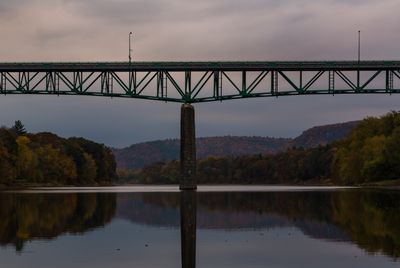
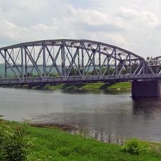
Milford–Montague Toll Bridge, Steel deck truss bridge in Delaware Water Gap National Recreation Area, United States.

The Milford-Montague Toll Bridge is a steel structure spanning the Delaware River and connecting New Jersey with Pennsylvania. The crossing stretches roughly 350 meters (1,150 feet) over the water and carries two vehicle lanes.

An earlier crossing built in 1889 operated for nearly 70 years before the current steel bridge replaced it in 1953. Growing traffic demands and modern engineering standards drove the decision to construct the new structure.

The bridge links two popular recreation areas and carries visitors traveling between the Pocono Mountains and the river valley below. Locals rely on it as a daily crossing for work and community connections.

Plan for wait times, especially on weekends and during peak tourism season in the Pocono Mountains region. Crossing on weekday mornings or early afternoons usually means lighter traffic flow and faster transit.

The bridge was intentionally built higher than necessary to accommodate a massive reservoir that was planned as part of an ambitious dam project. The reservoir was never constructed, leaving the bridge's extra height as a remnant of plans that never came to be.

The community of curious travelers

AroundUs brings together thousands of curated places, local tips, and hidden gems, enriched daily by 60,000 contributors worldwide.

Start exploring
Location
Location
Inception
December 30, 1953
Official opening
December 30, 1953
GPS coordinates
41.30710,-74.80020
Latest update
December 13, 2025 11:40
Around this place
High Point
United States of America

High Point

11.7 km
Grey Towers National Historic Site
United States of America

Grey Towers National Historic Site

2.9 km
High Point State Park
United States of America

High Point State Park

9.1 km
Tri-States Monument
United States of America

Tri-States Monument

10.4 km
Dingmans Falls
United States of America

Dingmans Falls

11.5 km
Dingman's Ferry Bridge
United States of America

Dingman's Ferry Bridge

10.9 km
Rutan Hill
United States of America

Rutan Hill

12.5 km
Silverthread Falls
United States of America

Silverthread Falls

11.2 km
Fulmer Falls
United States of America

Fulmer Falls

12.4 km
Deer Leap Falls
United States of America

Deer Leap Falls

12.5 km
Mid-Delaware Bridge
United States of America

Mid-Delaware Bridge

11.2 km
Fort Decker
United States of America

Fort Decker

11.4 km
Marie Zimmermann Farm
United States of America

Marie Zimmermann Farm

7.8 km
Factory Falls
United States of America

Factory Falls

12.5 km
Hotel Fauchere and Annex
United States of America

Hotel Fauchere and Annex

1.8 km
Pike County Courthouse
United States of America

Pike County Courthouse

1.9 km
Dingman's Ferry Dutch Reformed Church
United States of America

Dingman's Ferry Dutch Reformed Church

10.8 km
Callahan House
United States of America

Callahan House

1.1 km
Foster-Armstrong House
United States of America

Foster-Armstrong House

996 m
Mill Rift Hall
United States of America

Mill Rift Hall

12.5 km
Arisbe
United States of America

Arisbe

4.8 km
Jervis Gordon Grist Mill Historic District
United States of America

Jervis Gordon Grist Mill Historic District

2.1 km
Milford Theatre
United States of America

Milford Theatre

1.8 km
High Point Monument War Veterans Memorial
United States of America

High Point Monument War Veterans Memorial

11.7 km
Peters Valley Historic District
United States of America

Peters Valley Historic District

13.1 km
Milford Historic District
United States of America

Milford Historic District

1.8 km
Westbrook-Bell House
United States of America

Westbrook-Bell House

3.9 km
Nyce-Depue Farm
United States of America

Nyce-Depue Farm

7.6 km
Show the full map
« Milford–Montague Toll Bridge - Steel deck truss bridge in Delaware Water Gap National Recreation Area, United States » is provided by Around Us (aroundus.com). Images and texts are derived from Wikimedia project under a Creative Commons license. You are allowed to copy, distribute, and modify copies of this page, under the conditions set by the license, as long as this note is clearly visible.

Discover hidden gems everywhere you go!

From secret cafés to breathtaking viewpoints, skip the crowded tourist spots and find places that match your style. Our app makes it easy with voice search, smart filtering, route optimization, and insider tips from travelers worldwide. Download now for the complete mobile experience.

Around Us App Screenshot

A unique approach to discovering new places

Le Figaro

All the places worth exploring

France Info

A tailor-made excursion in just a few clicks

20 Minutes

Around Us
Travel Guide & Maps
Download

Send to your phone

QR Code
1

Open the camera app on your mobile.

2

Point at the QR code with your camera. A notification will appear.

3

Tap the notification to open the link.