Enable Location

We need your location to show you interesting places around you

Discover nearby places

Find interesting locations and hidden gems around you

Precise directions

Get accurate directions and distances to places

Your location is never shared with other users. It's only used when you tap the location button.

Marie Zimmermann Farm

Log in to your account

Start exploring — it's free

Trusted by 62,473 travelers worldwide

Continue with Google
Continue with Apple
or

We will send you a code to connect

By continuing, you accept our Terms and Conditions and our Privacy Policy

Check your inbox

We've sent a pincode in your inbox. Please enter the code below.

Marie Zimmermann Farm, Historic farm estate in Delaware Township, Pennsylvania.

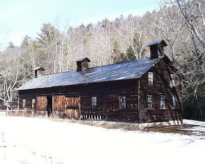
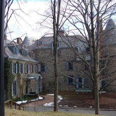
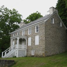
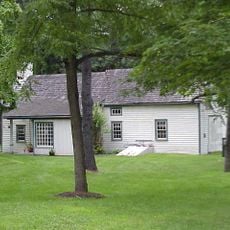
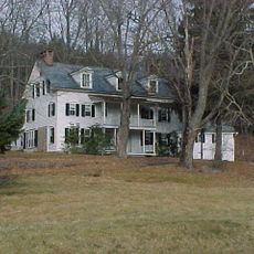
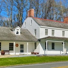
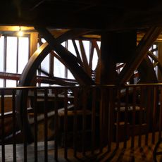
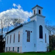
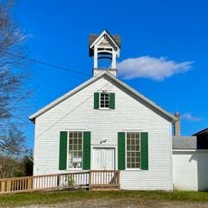
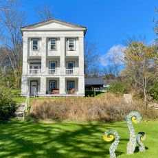
Marie Zimmermann Farm is a rural estate with a two-and-a-half-story fieldstone main house featuring a gambrel roof and French-style tower. The property also contains two frame barns, a second residence, and additional structures spread across the grounds.

The property was built in 1910 as the home of metal artist Marie Zimmermann, who lived there until 1972. It was officially recognized as a historic place in 1979 for its architectural and cultural importance.

The farm reflects how an artist shaped a rural home by blending residential comfort with working agricultural spaces through its design. Walking through, you see how the various buildings relate to each other as a complete farming community.

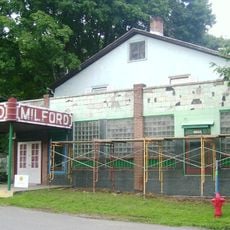
The farm sits southwest of Milford along U.S. Route 209, making it relatively easy to find and approach from the main road. You can walk through the different buildings and see how the property is organized across the open ground.

A round, two-story stone tower connects the main house and rear wing at their corner intersection. This unusual feature from the early 1900s sets the property apart from typical farm buildings of that era.

The community of curious travelers

AroundUs brings together thousands of curated places, local tips, and hidden gems, enriched daily by 60,000 contributors worldwide.

Start exploring
Location
GPS coordinates
41.25190,-74.85830
Latest update
December 14, 2025 12:21
Around this place
Delaware Water Gap National Recreation Area
United States of America

Delaware Water Gap National Recreation Area

11.9 km
Grey Towers National Historic Site
United States of America

Grey Towers National Historic Site

9 km
Dingmans Falls
United States of America

Dingmans Falls

3.7 km
Stokes State Forest
United States of America

Stokes State Forest

9.1 km
Dingman's Ferry Bridge
United States of America

Dingman's Ferry Bridge

3.5 km
Silverthread Falls
United States of America

Silverthread Falls

3.4 km
Fulmer Falls
United States of America

Fulmer Falls

5.1 km
Deer Leap Falls
United States of America

Deer Leap Falls

5.1 km
Milford–Montague Toll Bridge
United States of America

Milford–Montague Toll Bridge

7.8 km
Flat Brook
United States of America

Flat Brook

7.1 km
Van Campen's Inn
United States of America

Van Campen's Inn

10.1 km
Factory Falls
United States of America

Factory Falls

5.2 km
Hotel Fauchere and Annex
United States of America

Hotel Fauchere and Annex

9.3 km
Pike County Courthouse
United States of America

Pike County Courthouse

9.4 km
Dingman's Ferry Dutch Reformed Church
United States of America

Dingman's Ferry Dutch Reformed Church

3.1 km
Callahan House
United States of America

Callahan House

8.7 km
Brodhead Farm
United States of America

Brodhead Farm

12.5 km
Foster-Armstrong House
United States of America

Foster-Armstrong House

8.6 km
Andrew Snable House
United States of America

Andrew Snable House

9.2 km
Rutan Farm
United States of America

Rutan Farm

11.6 km
Arisbe
United States of America

Arisbe

12.6 km
Jervis Gordon Grist Mill Historic District
United States of America

Jervis Gordon Grist Mill Historic District

8.9 km
Milford Theatre
United States of America

Milford Theatre

9.3 km
Walpack Methodist Church
United States of America

Walpack Methodist Church

10.6 km
Wallpack Center Historic District
United States of America

Wallpack Center Historic District

10.5 km
Peters Valley Historic District
United States of America

Peters Valley Historic District

6.2 km
Milford Historic District
United States of America

Milford Historic District

9.2 km
Westbrook-Bell House
United States of America

Westbrook-Bell House

4 km
Show the full map
« Marie Zimmermann Farm - Historic farm estate in Delaware Township, Pennsylvania » is provided by Around Us (aroundus.com). Images and texts are derived from Wikimedia project under a Creative Commons license. You are allowed to copy, distribute, and modify copies of this page, under the conditions set by the license, as long as this note is clearly visible.

Discover hidden gems everywhere you go!

From secret cafés to breathtaking viewpoints, skip the crowded tourist spots and find places that match your style. Our app makes it easy with voice search, smart filtering, route optimization, and insider tips from travelers worldwide. Download now for the complete mobile experience.

Around Us App Screenshot

A unique approach to discovering new places

Le Figaro

All the places worth exploring

France Info

A tailor-made excursion in just a few clicks

20 Minutes

Around Us
Travel Guide & Maps
Download

Send to your phone

QR Code
1

Open the camera app on your mobile.

2

Point at the QR code with your camera. A notification will appear.

3

Tap the notification to open the link.