Enable Location

We need your location to show you interesting places around you

Discover nearby places

Find interesting locations and hidden gems around you

Precise directions

Get accurate directions and distances to places

Your location is never shared with other users. It's only used when you tap the location button.

Log in to your account

Start exploring — it's free

Trusted by 65,812 travelers worldwide

Continue with Google
Continue with Apple
or

We will send you a code to connect

By continuing, you accept our Terms and Conditions and our Privacy Policy

Check your inbox

We've sent a pincode in your inbox. Please enter the code below.

Nantahala Lake
Discussion Reviews Photo
7.6k Popularity

Nantahala Lake, Man made lake in Macon County, North Carolina

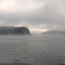
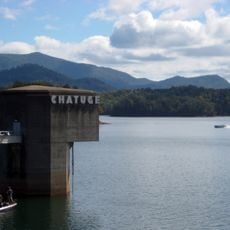
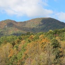
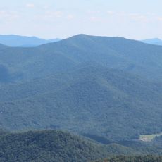
Nantahala Lake is a reservoir in the mountains of western North Carolina, sitting on the border of Macon County and Clay County. A dam holds back the water, and the shoreline runs along steep, forested slopes that drop directly to the water's edge.

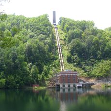
The lake was created in the 1940s when a dam was built by the Nantahala Power and Light Company to generate electricity for the region. The flooding of the valley changed the local landscape permanently, and the reservoir has supplied power to the area ever since.

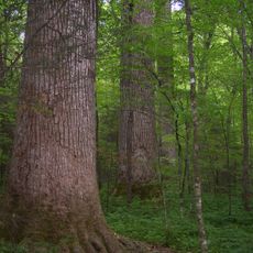
The name Nantahala comes from a Cherokee word meaning roughly "land of the noonday sun", a reference to how sunlight only reaches the valley floor for a short time each day. This connection to Cherokee language and history gives the lake and its surroundings a deeper layer of meaning that many visitors notice when they start exploring the area.

Several boat launches and shoreline access points are scattered around the lake, making it easy to reach the water by foot or by boat. Weather in the mountains can shift quickly, so it is worth checking conditions before heading out, especially in the cooler months.

The water in the lake stays unusually cold even in summer, which makes it one of the few places in the region where trout can thrive without special stocking programs. This cold water comes from the depth of the reservoir and the shaded mountain slopes that keep sunlight from warming the surface for most of the day.

The community of curious travelers

AroundUs brings together thousands of curated places, local tips, and hidden gems, enriched daily by 60,000 contributors worldwide.

Start exploring
Location
Location
GPS coordinates
35.18086,-83.68276
Latest update
March 3, 2026 08:17
Around this place
Fontana Lake
United States of America

Fontana Lake

31.7 km
Chatuge Lake
United States of America

Chatuge Lake

23.1 km
Joyce Kilmer Memorial Forest
United States of America

Joyce Kilmer Memorial Forest

34.2 km
John C. Campbell Folk School
United States of America

John C. Campbell Folk School

30.3 km
Joyce Kilmer-Slickrock Wilderness
United States of America

Joyce Kilmer-Slickrock Wilderness

34.2 km
Nikwasi
United States of America

Nikwasi

28.8 km
Santeetlah Dam
United States of America

Santeetlah Dam

28.1 km
Southern Nantahala Wilderness
United States of America

Southern Nantahala Wilderness

23.2 km
Fred Hamilton Rhododendron Garden
United States of America

Fred Hamilton Rhododendron Garden

20.7 km
Double Spring Knob
United States of America

Double Spring Knob

33.8 km
Swain County Courthouse
United States of America

Swain County Courthouse

34.9 km
Spikebuck Town Mound and Village Site
United States of America

Spikebuck Town Mound and Village Site

18.9 km
Robert Lafayette Cooper House
United States of America

Robert Lafayette Cooper House

33.3 km
Cherokee County Courthouse
United States of America

Cherokee County Courthouse

33.6 km
First Baptist Church
United States of America

First Baptist Church

13.1 km
Bull Cove Falls
United States of America

Bull Cove Falls

23.5 km
Saint Agnes Episcopal Church
United States of America

Saint Agnes Episcopal Church

27.3 km
Franklin Pierce Cover House
United States of America

Franklin Pierce Cover House

13.3 km
Franklin Presbyterian Church
United States of America

Franklin Presbyterian Church

27.2 km
Towns County Jail
United States of America

Towns County Jail

27 km
Albert Swain Bryson House
United States of America

Albert Swain Bryson House

27.9 km
Graham County Courthouse
United States of America

Graham County Courthouse

19.4 km
Young Harris College Historic District
United States of America

Young Harris College Historic District

31.4 km
Jesse R. Siler House
United States of America

Jesse R. Siler House

26.9 km
Clay County Courthouse
United States of America

Clay County Courthouse

19.5 km
Hambidge Center Historic District
United States of America

Hambidge Center Historic District

31 km
Charles Noden George House
United States of America

Charles Noden George House

11.5 km
Swain County Visitor Center and Heritage Museum
United States of America

Swain County Visitor Center and Heritage Museum

35 km
Show the full map
Reviews
Share your experience

No review yet

Discussions
Start a discussion...

No discussion yet

« Nantahala Lake - Man made lake in Macon County, North Carolina » is provided by Around Us (aroundus.com). Images and texts are derived from Wikimedia project under a Creative Commons license. You are allowed to copy, distribute, and modify copies of this page, under the conditions set by the license, as long as this note is clearly visible.

Discover hidden gems everywhere you go!

From secret cafés to breathtaking viewpoints, skip the crowded tourist spots and find places that match your style. Our app makes it easy with voice search, smart filtering, route optimization, and insider tips from travelers worldwide. Download now for the complete mobile experience.

Around Us App Screenshot

A unique approach to discovering new places

Le Figaro

All the places worth exploring

France Info

A tailor-made excursion in just a few clicks

20 Minutes

Around Us
Travel Guide & Maps
Download

Send to your phone

QR Code
1

Open the camera app on your mobile.

2

Point at the QR code with your camera. A notification will appear.

3

Tap the notification to open the link.