Enable Location

We need your location to show you interesting places around you

Discover nearby places

Find interesting locations and hidden gems around you

Precise directions

Get accurate directions and distances to places

Your location is never shared with other users. It's only used when you tap the location button.

Narbrook Park Historic District

Log in to your account

Start exploring — it's free

Trusted by 61,665 travelers worldwide

Continue with Google
Continue with Apple
or

We will send you a code to connect

By continuing, you accept our Terms and Conditions and our Privacy Policy

Check your inbox

We've sent a pincode in your inbox. Please enter the code below.

Narbrook Park Historic District, Garden suburb historic district in Narberth, United States.

Description

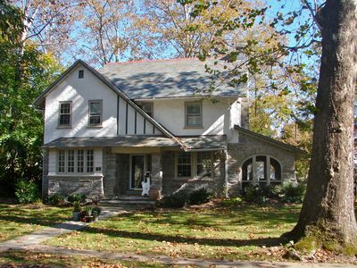
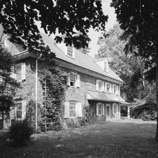
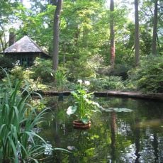
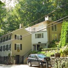
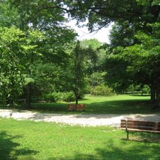
Narbrook Park Historic District is a garden suburb with thirty-five detached houses on approximately 14 acres featuring integrated green spaces throughout the residential area. The dwellings vary in architectural style and are connected by asphalt paths alongside trees and planted areas.

History

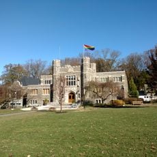
The district was developed between 1915 and 1938 as part of early suburban planning ideals, with architect George Burdett Ford designing the layout. This project reflected the belief of that era that gardens and carefully planned residential development should work together.

Culture

The residential buildings display various architectural styles including Bungalow, American Craftsman, and Dutch Colonial Revival forms within a planned garden layout. This arrangement shapes how residents experience daily life surrounded by these different design approaches.

Practical

The district is best explored on foot since it was designed with connected walkways that run between the houses and beneath trees. Walking through reveals both the buildings and the garden layout that runs throughout the entire area.

Did you know?

The Narbrook Park Improvement Association, made up of residents, has long been responsible for maintaining and caring for the entire district. This self-governance system is uncommon and shows how the community actively shapes its own surroundings.

Location
GPS coordinates
40.00720,-75.26670
Latest update
December 14, 2025 14:40

AroundUs brings together thousands of curated places, local tips, and hidden gems, enriched daily by 60,000 contributors worldwide. Discover all places nearby (Narberth).

Around this place
Merion Golf Club
United States of America

Merion Golf Club

3.9 km
Mann Center for the Performing Arts
United States of America

Mann Center for the Performing Arts

4.6 km
Suntop Homes
United States of America

Suntop Homes

2.3 km
Manayunk Bridge
United States of America

Manayunk Bridge

4 km
Temple Adath Israel of the Main Line
United States of America

Temple Adath Israel of the Main Line

2.4 km
Wynnestay
United States of America

Wynnestay

3.4 km
Arboretum of the Barnes Foundation
United States of America

Arboretum of the Barnes Foundation

2.3 km
Old Library
United States of America

Old Library

4.6 km
Whitehall Apartments
United States of America

Whitehall Apartments

3.2 km
Pont Reading
United States of America

Pont Reading

3.3 km
Idlewild Farm Complex
United States of America

Idlewild Farm Complex

3.9 km
Pencoyd Bridge
United States of America

Pencoyd Bridge

4.7 km
Nitre Hall
United States of America

Nitre Hall

3.1 km
St. Josaphat Roman Catholic Church in Philadelphia
United States of America

St. Josaphat Roman Catholic Church in Philadelphia

4.4 km
City Line Avenue Bridge
United States of America

City Line Avenue Bridge

2.5 km
Green Lane Bridge
United States of America

Green Lane Bridge

3.9 km
Mill Creek Historic District
United States of America

Mill Creek Historic District

2.6 km
Dove Lake
United States of America

Dove Lake

3.4 km
United States of America

Bala Theatre

3 km
Gladwyne Historic District
United States of America

Gladwyne Historic District

3.5 km
Belmont Avenue Bridge in Philadelphia
United States of America

Belmont Avenue Bridge in Philadelphia

4.4 km
Henry Foundation for Botanical Research
United States of America

Henry Foundation for Botanical Research

3.2 km
Monte Vista
United States of America

Monte Vista

3.6 km
Mule Bridge
United States of America

Mule Bridge

4.3 km
House of Prayer Episcopal Church, Philadelphia
United States of America

House of Prayer Episcopal Church, Philadelphia

881 m
Merion Botanical Park
United States of America

Merion Botanical Park

1.9 km
Fountain Street Steps
United States of America

Fountain Street Steps

4 km
Bryn Mawr College Historic District
United States of America

Bryn Mawr College Historic District

4.5 km
Show the full map
« Narbrook Park Historic District - Garden suburb historic district in Narberth, United States » is provided by Around Us (aroundus.com). Images and texts are derived from Wikimedia project under a Creative Commons license. You are allowed to copy, distribute, and modify copies of this page, under the conditions set by the license, as long as this note is clearly visible.

Discover hidden gems everywhere you go!

From secret cafés to breathtaking viewpoints, skip the crowded tourist spots and find places that match your style. Our app makes it easy with voice search, smart filtering, route optimization, and insider tips from travelers worldwide. Download now for the complete mobile experience.

Around Us App Screenshot

A unique approach to discovering new places

Le Figaro

All the places worth exploring

France Info

A tailor-made excursion in just a few clicks

20 Minutes

Around Us
Travel Guide & Maps
Download

Send to your phone

QR Code
1

Open the camera app on your mobile.

2

Point at the QR code with your camera. A notification will appear.

3

Tap the notification to open the link.