Chest opened
+${chestReward.xp} XP
Explorer
NOUVEAU ×${chestReward.collectible.quantity}
tapez pour fermer
Chest locked

Open chests in the app

Around Us is built for your phone — chests unlock when you walk, explore and capture nearby places.

Enable Location

We need your location to show you interesting places around you

Discover nearby places

Find interesting locations and hidden gems around you

Precise directions

Get accurate directions and distances to places

Your location is never shared with other users. It's only used when you tap the location button.

Log in to your account

Start exploring — it's free

Trusted by 72,889 travelers worldwide

Continue with Google
Continue with Apple
or

We will send you a code to connect

By continuing, you accept our Terms and Conditions and our Privacy Policy

Check your inbox

We've sent a pincode in your inbox. Please enter the code below.

Norwalk Harbor
Discussion Reviews Photo
2.6k Popularity

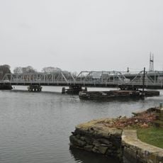
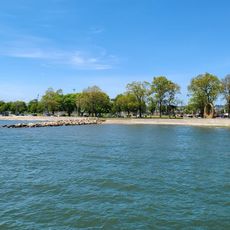
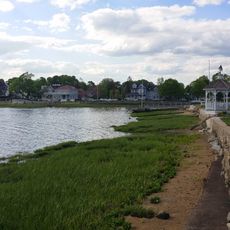
Norwalk Harbor, Natural port at Long Island Sound, Connecticut, US

Norwalk Harbor is a natural port on Long Island Sound that contains about fifteen marinas and thirteen private boating clubs spread across the Norwalk River estuary. Together these facilities offer hundreds of mooring spaces for both recreational and commercial vessels.

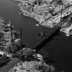
The harbor began receiving major improvements in 1872 when the U.S. Army Corps of Engineers started dredging to improve navigation. These early works transformed it from a shallow waterway into the functioning port it remains today.

Oyster and lobster fishing remains central to the harbor's working character and local food culture. Visitors can observe fishing boats and purchase fresh seafood directly from working waterfront businesses.

The harbor provides mooring and anchoring options in different areas suited to various vessel types. Visitors exploring on foot should watch for uneven or slippery surfaces along the waterfront paths.

The harbor handles thousands of cargo movements each year, shipping materials like fuel, sand, gravel, and stone alongside seafood products. This busy commercial activity makes it an interesting place to watch working port operations in action.

The community of curious travelers

AroundUs brings together thousands of curated places, local tips, and hidden gems, enriched daily by 60,000 contributors worldwide.

Start exploring
Location
GPS coordinates
41.09010,-73.40600
Latest update
December 12, 2025 17:47
Around this place
Lockwood-Mathews Mansion
United States of America

Lockwood-Mathews Mansion

2.3 km
Maritime Aquarium at Norwalk
United States of America

Maritime Aquarium at Norwalk

1.5 km
Norwalk River Railroad Bridge
United States of America

Norwalk River Railroad Bridge

1.4 km
Stepping Stones Museum for Children
United States of America

Stepping Stones Museum for Children

2.4 km
Sheffield Island Light
United States of America

Sheffield Island Light

4.7 km
Village Creek
United States of America

Village Creek

1.6 km
Saint Mary Church
United States of America

Saint Mary Church

2.8 km
Saugatuck River Bridge
United States of America

Saugatuck River Bridge

4.8 km
Rock Ledge
United States of America

Rock Ledge

3.7 km
Beth Israel Synagogue
United States of America

Beth Israel Synagogue

1.2 km
Saugatuck River Railroad Bridge
United States of America

Saugatuck River Railroad Bridge

4.5 km
Mill Hill Historic Park
United States of America

Mill Hill Historic Park

3.1 km
Compo–Owenoke Historic District
United States of America

Compo–Owenoke Historic District

4.6 km
South Main and Washington Streets Historic District
United States of America

South Main and Washington Streets Historic District

947 m
Peck Ledge Light
United States of America

Peck Ledge Light

3.4 km
The Allen House
United States of America

The Allen House

3.8 km
Norwalk Green Historic District
United States of America

Norwalk Green Historic District

3.2 km
South Norwalk Railroad Bridge
United States of America

South Norwalk Railroad Bridge

1.5 km
Kayak for a Cause
United States of America

Kayak for a Cause

1.1 km
Five Mile River Landing Historic District
United States of America

Five Mile River Landing Historic District

3.8 km
SoNo Switch Tower
United States of America

SoNo Switch Tower

1.5 km
Wall Street Historic District
United States of America

Wall Street Historic District

3.2 km
Calf Pasture Beach
United States of America

Calf Pasture Beach

1.3 km
United States Post Office–South Norwalk Main
United States of America

United States Post Office–South Norwalk Main

1.6 km
Norwalk City Hall
United States of America

Norwalk City Hall

1.5 km
Haviland and Elizabeth Streets-Hanford Place Historic District
United States of America

Haviland and Elizabeth Streets-Hanford Place Historic District

1.3 km
SONO 50
United States of America

SONO 50

1.7 km
Marvin Beach
United States of America

Marvin Beach

474 m
Show the full map
Reviews
Share your experience

No review yet

Discussions
Start a discussion...

No discussion yet

« Norwalk Harbor - Natural port at Long Island Sound, Connecticut, US » is provided by Around Us (aroundus.com). Images and texts are derived from Wikimedia project under a Creative Commons license. You are allowed to copy, distribute, and modify copies of this page, under the conditions set by the license, as long as this note is clearly visible.

Discover hidden gems everywhere you go!

From secret cafés to breathtaking viewpoints, skip the crowded tourist spots and find places that match your style. Our app makes it easy with voice search, smart filtering, route optimization, and insider tips from travelers worldwide. Download now for the complete mobile experience.

Around Us App Screenshot

A unique approach to discovering new places

Le Figaro

All the places worth exploring

France Info

A tailor-made excursion in just a few clicks

20 Minutes

Around Us
Travel Guide & Maps
Download

Send to your phone

QR Code
1

Open the camera app on your mobile.

2

Point at the QR code with your camera. A notification will appear.

3

Tap the notification to open the link.