Enable Location

We need your location to show you interesting places around you

Discover nearby places

Find interesting locations and hidden gems around you

Precise directions

Get accurate directions and distances to places

Your location is never shared with other users. It's only used when you tap the location button.

Saugatuck River Bridge

Log in to your account

Start exploring — it's free

Trusted by 62,979 travelers worldwide

Continue with Google
Continue with Apple
or

We will send you a code to connect

By continuing, you accept our Terms and Conditions and our Privacy Policy

Check your inbox

We've sent a pincode in your inbox. Please enter the code below.

Discussion Reviews 1 Photos
2.1k Popularity

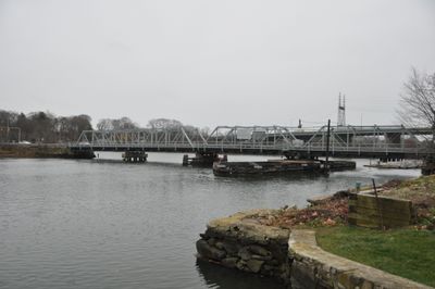
Saugatuck River Bridge, Road bridge over Saugatuck River in Westport, United States

Saugatuck River Bridge is a road crossing made of wrought iron that spans the river with a pin-connected truss design supporting the deck. It carries Route 136 across the water and features a roadway about 20 feet wide.

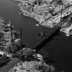
This crossing was built in 1884 to replace an earlier wooden bridge that had deteriorated from shipworm damage. The construction came from Union Bridge Company of Buffalo and represented a significant upgrade to local infrastructure at that time.

The bridge forms a central landmark in the Bridge Street Historic District and defines the visual character of this neighborhood. Locals and visitors alike recognize it as a symbol that connects the community's past with its present landscape.

Traffic crosses this span in both directions on a regular daily basis as a standard transit route. Visitors should remember this is an active roadway and full attention is needed when near or crossing the structure.

This is Connecticut's oldest operational movable bridge and remains the only hand-cranked crossing in the state. The manual operating mechanism is a working relic from the past that still functions today.

The community of curious travelers

AroundUs brings together thousands of curated places, local tips, and hidden gems, enriched daily by 60,000 contributors worldwide.

Start exploring
Location
Inception
1884
Architects
Union Bridge Company
Part of
Bridge Street Historic District
GPS coordinates
41.12280,-73.36940
Latest update
December 14, 2025 09:46
Around this place
Merritt Parkway
United States of America

Merritt Parkway

4.5 km
Lockwood-Mathews Mansion
United States of America

Lockwood-Mathews Mansion

4.3 km
Sherwood Island State Park
United States of America

Sherwood Island State Park

3.6 km
Westport Country Playhouse
United States of America

Westport Country Playhouse

2.4 km
Norwalk River Railroad Bridge
United States of America

Norwalk River Railroad Bridge

4.6 km
Stepping Stones Museum for Children
United States of America

Stepping Stones Museum for Children

4.3 km
Earthplace
United States of America

Earthplace

2.9 km
Saint Mary Church
United States of America

Saint Mary Church

3.9 km
Louis Micheels House
United States of America

Louis Micheels House

2 km
Saugatuck River Railroad Bridge
United States of America

Saugatuck River Railroad Bridge

376 m
Westport Public Library
United States of America

Westport Public Library

2.1 km
Mill Hill Historic Park
United States of America

Mill Hill Historic Park

3.4 km
Compo–Owenoke Historic District
United States of America

Compo–Owenoke Historic District

2.2 km
Our Lady of the Assumption Church
United States of America

Our Lady of the Assumption Church

1.5 km
South Main and Washington Streets Historic District
United States of America

South Main and Washington Streets Historic District

4.1 km
Godillot Place
United States of America

Godillot Place

2.1 km
Town Hall
United States of America

Town Hall

2.2 km
The Allen House
United States of America

The Allen House

932 m
Norwalk Green Historic District
United States of America

Norwalk Green Historic District

3.3 km
Wall Street Historic District
United States of America

Wall Street Historic District

3.6 km
Westport Bank and Trust Company
United States of America

Westport Bank and Trust Company

2.2 km
Mill Cove Historic District
United States of America

Mill Cove Historic District

2.5 km
Kings Highway North Historic District
United States of America

Kings Highway North Historic District

2 km
Bradley-Wheeler House
United States of America

Bradley-Wheeler House

2.5 km
National Hall Historic District
United States of America

National Hall Historic District

2 km
Shambaugh House
United States of America

Shambaugh House

2.3 km
Bridge Street Historic District
United States of America

Bridge Street Historic District

417 m
Compo Beach
United States of America

Compo Beach

2.4 km
Show the full map
Reviews
Share your experience

No review yet

Discussions
Start a discussion...

No discussion yet

« Saugatuck River Bridge - Road bridge over Saugatuck River in Westport, United States » is provided by Around Us (aroundus.com). Images and texts are derived from Wikimedia project under a Creative Commons license. You are allowed to copy, distribute, and modify copies of this page, under the conditions set by the license, as long as this note is clearly visible.

Discover hidden gems everywhere you go!

From secret cafés to breathtaking viewpoints, skip the crowded tourist spots and find places that match your style. Our app makes it easy with voice search, smart filtering, route optimization, and insider tips from travelers worldwide. Download now for the complete mobile experience.

Around Us App Screenshot

A unique approach to discovering new places

Le Figaro

All the places worth exploring

France Info

A tailor-made excursion in just a few clicks

20 Minutes

Around Us
Travel Guide & Maps
Download

Send to your phone

QR Code
1

Open the camera app on your mobile.

2

Point at the QR code with your camera. A notification will appear.

3

Tap the notification to open the link.