Enable Location

We need your location to show you interesting places around you

Discover nearby places

Find interesting locations and hidden gems around you

Precise directions

Get accurate directions and distances to places

Your location is never shared with other users. It's only used when you tap the location button.

Compo–Owenoke Historic District

Log in to your account

Start exploring — it's free

Trusted by 62,958 travelers worldwide

Continue with Google
Continue with Apple
or

We will send you a code to connect

By continuing, you accept our Terms and Conditions and our Privacy Policy

Check your inbox

We've sent a pincode in your inbox. Please enter the code below.

Discussion Reviews 1 Photos
1.6k Popularity

Compo–Owenoke Historic District, Coastal historic district in Westport, United States.

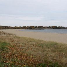
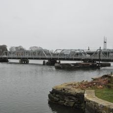
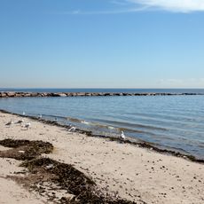
The Compo-Owenoke Historic District is a coastal area in Westport that covers about 150 acres along Long Island Sound. More than 200 houses from different periods stand here, along with a marina and recreational spaces.

The area was originally farmland until development began in 1909 when a real estate developer purchased the land. The transformation from agricultural use to a summer community accelerated over the following decades.

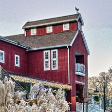
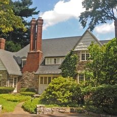
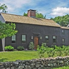
The houses show the building styles that coastal New England communities preferred in the early 1900s. The mixture of Colonial Revival, Tudor Revival, and Craftsman designs reflects how wealthy residents wanted their summer homes to look.

The district sits south of Compo Road South and stretches toward the water. You can explore it best on foot by walking through the residential streets and along the shoreline.

Part of Owenoke Point was originally an island that was connected to the mainland through landfill in the 1930s. This landfill project significantly reshaped the shoreline and created new buildable land.

The community of curious travelers

AroundUs brings together thousands of curated places, local tips, and hidden gems, enriched daily by 60,000 contributors worldwide.

Start exploring
Location
Location
Elevation above the sea
4 m
GPS coordinates
41.10611,-73.35500
Latest update
December 14, 2025 14:22
Around this place
Sherwood Island State Park
United States of America

Sherwood Island State Park

2.6 km
Westport Country Playhouse
United States of America

Westport Country Playhouse

4 km
Norwalk River Railroad Bridge
United States of America

Norwalk River Railroad Bridge

5.1 km
Earthplace
United States of America

Earthplace

5.1 km
Saint Mary Church
United States of America

Saint Mary Church

5.1 km
Saugatuck River Bridge
United States of America

Saugatuck River Bridge

2.2 km
Louis Micheels House
United States of America

Louis Micheels House

787 m
Saugatuck River Railroad Bridge
United States of America

Saugatuck River Railroad Bridge

1.9 km
Westport Public Library
United States of America

Westport Public Library

3.9 km
Mill Hill Historic Park
United States of America

Mill Hill Historic Park

4.7 km
Our Lady of the Assumption Church
United States of America

Our Lady of the Assumption Church

3.4 km
South Main and Washington Streets Historic District
United States of America

South Main and Washington Streets Historic District

4.4 km
Peck Ledge Light
United States of America

Peck Ledge Light

3.4 km
Godillot Place
United States of America

Godillot Place

3.8 km
Town Hall
United States of America

Town Hall

3.9 km
The Allen House
United States of America

The Allen House

2 km
Norwalk Green Historic District
United States of America

Norwalk Green Historic District

4.7 km
Kayak for a Cause
United States of America

Kayak for a Cause

4.2 km
Wall Street Historic District
United States of America

Wall Street Historic District

5 km
Westport Bank and Trust Company
United States of America

Westport Bank and Trust Company

4 km
Mill Cove Historic District
United States of America

Mill Cove Historic District

1.3 km
Kings Highway North Historic District
United States of America

Kings Highway North Historic District

4 km
Bradley-Wheeler House
United States of America

Bradley-Wheeler House

4.3 km
National Hall Historic District
United States of America

National Hall Historic District

3.9 km
Shambaugh House
United States of America

Shambaugh House

4.4 km
Bridge Street Historic District
United States of America

Bridge Street Historic District

2 km
Compo Beach
United States of America

Compo Beach

374 m
John Osborne House
United States of America

John Osborne House

4.9 km
Show the full map
Reviews
Share your experience

No review yet

Discussions
Start a discussion...

No discussion yet

« Compo–Owenoke Historic District - Coastal historic district in Westport, United States » is provided by Around Us (aroundus.com). Images and texts are derived from Wikimedia project under a Creative Commons license. You are allowed to copy, distribute, and modify copies of this page, under the conditions set by the license, as long as this note is clearly visible.

Discover hidden gems everywhere you go!

From secret cafés to breathtaking viewpoints, skip the crowded tourist spots and find places that match your style. Our app makes it easy with voice search, smart filtering, route optimization, and insider tips from travelers worldwide. Download now for the complete mobile experience.

Around Us App Screenshot

A unique approach to discovering new places

Le Figaro

All the places worth exploring

France Info

A tailor-made excursion in just a few clicks

20 Minutes

Around Us
Travel Guide & Maps
Download

Send to your phone

QR Code
1

Open the camera app on your mobile.

2

Point at the QR code with your camera. A notification will appear.

3

Tap the notification to open the link.