Enable Location

We need your location to show you interesting places around you

Discover nearby places

Find interesting locations and hidden gems around you

Precise directions

Get accurate directions and distances to places

Your location is never shared with other users. It's only used when you tap the location button.

Our Lady of the Assumption Church

Log in to your account

Start exploring — it's free

Trusted by 62,958 travelers worldwide

Continue with Google
Continue with Apple
or

We will send you a code to connect

By continuing, you accept our Terms and Conditions and our Privacy Policy

Check your inbox

We've sent a pincode in your inbox. Please enter the code below.

Our Lady of the Assumption Church
Discussion Reviews 1 Photos
1.5k Popularity

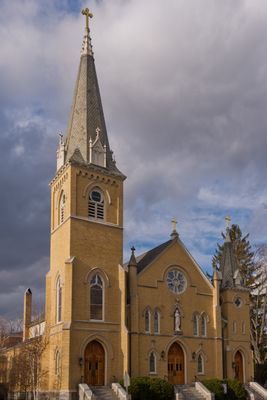
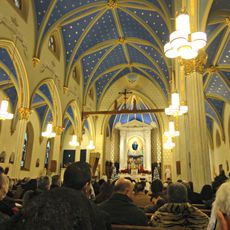
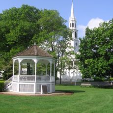
Our Lady of the Assumption Church, Catholic church in Fairfield County, Connecticut.

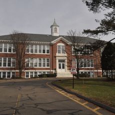
Our Lady of the Assumption Church is a Catholic place of worship in Fairfield County with traditional architectural details and a prominent bell tower. The building serves as a religious gathering space for the surrounding community.

This house of worship was founded in the early 1900s to serve the growing Catholic population in Fairfield County. Its creation coincided with the period of suburban expansion and population growth in the region.

The parish organizes regular religious education classes and seasonal celebrations that bring families together across generations. These gatherings remain an important part of community life in the area.

Services are held daily at set times, with additional Masses on weekends and religious holidays throughout the year. Visitors should check current times ahead of a visit, as schedules may vary seasonally.

The church broadcasts its services through FM radio, allowing worshippers to participate in Masses directly from their vehicles. This technology keeps the community connected, even for those unable to attend in person.

The community of curious travelers

AroundUs brings together thousands of curated places, local tips, and hidden gems, enriched daily by 60,000 contributors worldwide.

Start exploring
Location
GPS coordinates
41.13620,-73.36470
Latest update
December 14, 2025 14:40
Around this place
Merritt Parkway
United States of America

Merritt Parkway

3.8 km
Lockwood-Mathews Mansion
United States of America

Lockwood-Mathews Mansion

5.3 km
Sherwood Island State Park
United States of America

Sherwood Island State Park

3.9 km
Westport Country Playhouse
United States of America

Westport Country Playhouse

1 km
Stepping Stones Museum for Children
United States of America

Stepping Stones Museum for Children

5.3 km
Earthplace
United States of America

Earthplace

1.8 km
Saint Mary Church
United States of America

Saint Mary Church

4.8 km
Saugatuck River Bridge
United States of America

Saugatuck River Bridge

1.5 km
Louis Micheels House
United States of America

Louis Micheels House

2.9 km
Saugatuck River Railroad Bridge
United States of America

Saugatuck River Railroad Bridge

1.9 km
Westport Public Library
United States of America

Westport Public Library

574 m
Mill Hill Historic Park
United States of America

Mill Hill Historic Park

4.3 km
Compo–Owenoke Historic District
United States of America

Compo–Owenoke Historic District

3.4 km
United States of America

Westport Observatory

4.8 km
South Main and Washington Streets Historic District
United States of America

South Main and Washington Streets Historic District

5.4 km
Godillot Place
United States of America

Godillot Place

617 m
Town Hall
United States of America

Town Hall

636 m
The Allen House
United States of America

The Allen House

2.4 km
Norwalk Green Historic District
United States of America

Norwalk Green Historic District

4.2 km
Wall Street Historic District
United States of America

Wall Street Historic District

4.5 km
Westport Bank and Trust Company
United States of America

Westport Bank and Trust Company

679 m
Mill Cove Historic District
United States of America

Mill Cove Historic District

3.2 km
Kings Highway North Historic District
United States of America

Kings Highway North Historic District

573 m
Bradley-Wheeler House
United States of America

Bradley-Wheeler House

929 m
National Hall Historic District
United States of America

National Hall Historic District

455 m
Shambaugh House
United States of America

Shambaugh House

964 m
Bridge Street Historic District
United States of America

Bridge Street Historic District

1.5 km
Compo Beach
United States of America

Compo Beach

3.5 km
Show the full map
Reviews
Share your experience

No review yet

Discussions
Start a discussion...

No discussion yet

« Our Lady of the Assumption Church - Catholic church in Fairfield County, Connecticut » is provided by Around Us (aroundus.com). Images and texts are derived from Wikimedia project under a Creative Commons license. You are allowed to copy, distribute, and modify copies of this page, under the conditions set by the license, as long as this note is clearly visible.

Discover hidden gems everywhere you go!

From secret cafés to breathtaking viewpoints, skip the crowded tourist spots and find places that match your style. Our app makes it easy with voice search, smart filtering, route optimization, and insider tips from travelers worldwide. Download now for the complete mobile experience.

Around Us App Screenshot

A unique approach to discovering new places

Le Figaro

All the places worth exploring

France Info

A tailor-made excursion in just a few clicks

20 Minutes

Around Us
Travel Guide & Maps
Download

Send to your phone

QR Code
1

Open the camera app on your mobile.

2

Point at the QR code with your camera. A notification will appear.

3

Tap the notification to open the link.