Enable Location

We need your location to show you interesting places around you

Discover nearby places

Find interesting locations and hidden gems around you

Precise directions

Get accurate directions and distances to places

Your location is never shared with other users. It's only used when you tap the location button.

Panther Den Wilderness

Log in to your account

Start exploring — it's free

Trusted by 66,088 travelers worldwide

Continue with Google
Continue with Apple
or

We will send you a code to connect

By continuing, you accept our Terms and Conditions and our Privacy Policy

Check your inbox

We've sent a pincode in your inbox. Please enter the code below.

Panther Den Wilderness
Discussion Reviews 1 Photos
3.6k Popularity

Panther Den Wilderness, Protected wilderness area in Union County, Illinois.

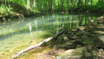
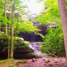
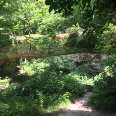
Panther Den Wilderness is a protected natural area in Union County, Illinois, covering dense forest, sandstone outcrops, and deep ravines carved into the hillsides. The terrain is steep in places and broken up by rocky ridges, making the landscape varied and physically demanding to cross on foot.

Congress designated this area as a wilderness in 1990, capping decades of conservation effort aimed at keeping the land free from development. The decision was part of a wider push to protect natural forest land across Illinois.

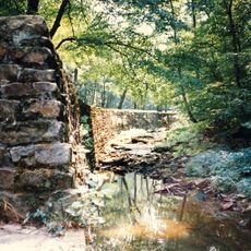
The name "Panther Den" refers to the big cats that once sheltered in the sandstone caves across these ridges, and locals still use that name today as a reminder of the wildlife that shaped the land. Walking the ravines, it is easy to understand why both animals and people found these rocky hollows useful as shelter.

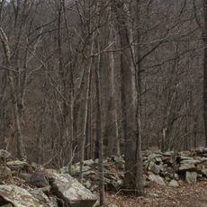
Trails here are barely marked, so carrying a paper map and compass is a good idea before heading in. There are no facilities on site, so bringing enough water and planning your route in advance makes the visit much smoother.

The sandstone caves and crevices scattered through the area can be easy to walk past without noticing, yet stepping closer reveals hidden passages and small chambers tucked between the rock faces. Some of these openings are narrow enough that they only become visible once you are standing right in front of them.

The community of curious travelers

AroundUs brings together thousands of curated places, local tips, and hidden gems, enriched daily by 60,000 contributors worldwide.

Start exploring
Location
Inception
1990
GPS coordinates
37.59280,-89.07500
Latest update
March 3, 2026 14:00
Around this place
R. Buckminster Fuller and Anne Hewlett Dome Home
United States of America

R. Buckminster Fuller and Anne Hewlett Dome Home

19.7 km
Giant City State Park
United States of America

Giant City State Park

10.1 km
Saluki Stadium
United States of America

Saluki Stadium

17.9 km
Bald Knob Cross
United States of America

Bald Knob Cross

24.4 km
Ferne Clyffe State Park
United States of America

Ferne Clyffe State Park

10.8 km
Giant City Stone Fort Site
United States of America

Giant City Stone Fort Site

11.3 km
Williamson County Jail
United States of America

Williamson County Jail

20.1 km
Trail of Tears State Forest
United States of America

Trail of Tears State Forest

25 km
Shryock Auditorium
United States of America

Shryock Auditorium

18.6 km
Faner Hall
United States of America

Faner Hall

18.6 km
Pomona Natural Bridge
United States of America

Pomona Natural Bridge

24.5 km
Altgeld Hall
United States of America

Altgeld Hall

18.7 km
Stinson Memorial Library
United States of America

Stinson Memorial Library

21.6 km
Willis Allen House
United States of America

Willis Allen House

19.8 km
John Bridges Tavern and Store Site
United States of America

John Bridges Tavern and Store Site

18.3 km
Goddard Chapel
United States of America

Goddard Chapel

21 km
Campground Church and Cemetery Site
United States of America

Campground Church and Cemetery Site

15.7 km
Thompson Brothers Rock Art
United States of America

Thompson Brothers Rock Art

10.4 km
Williamson County Courthouse
United States of America

Williamson County Courthouse

20.2 km
St. Anne's Episcopal Church
United States of America

St. Anne's Episcopal Church

21.6 km
Reef House
United States of America

Reef House

19.4 km
Ed M. Stotlar House
United States of America

Ed M. Stotlar House

19.6 km
West Walnut Street Historic District
United States of America

West Walnut Street Historic District

19.8 km
Carbondale Public Library
United States of America

Carbondale Public Library

19.7 km
John A. Logan College
United States of America

John A. Logan College

17.4 km
AMC Classic Illinois Centre 8
United States of America

AMC Classic Illinois Centre 8

19.5 km
Varsity Center for the Arts
United States of America

Varsity Center for the Arts

19.3 km
Campus Lake
United States of America

Campus Lake

18.6 km
Show the full map
Reviews
Share your experience

No review yet

Discussions
Start a discussion...

No discussion yet

« Panther Den Wilderness - Protected wilderness area in Union County, Illinois » is provided by Around Us (aroundus.com). Images and texts are derived from Wikimedia project under a Creative Commons license. You are allowed to copy, distribute, and modify copies of this page, under the conditions set by the license, as long as this note is clearly visible.

Discover hidden gems everywhere you go!

From secret cafés to breathtaking viewpoints, skip the crowded tourist spots and find places that match your style. Our app makes it easy with voice search, smart filtering, route optimization, and insider tips from travelers worldwide. Download now for the complete mobile experience.

Around Us App Screenshot

A unique approach to discovering new places

Le Figaro

All the places worth exploring

France Info

A tailor-made excursion in just a few clicks

20 Minutes

Around Us
Travel Guide & Maps
Download

Send to your phone

QR Code
1

Open the camera app on your mobile.

2

Point at the QR code with your camera. A notification will appear.

3

Tap the notification to open the link.