Enable Location

We need your location to show you interesting places around you

Discover nearby places

Find interesting locations and hidden gems around you

Precise directions

Get accurate directions and distances to places

Your location is never shared with other users. It's only used when you tap the location button.

Log in to your account

Start exploring — it's free

Trusted by 64,560 travelers worldwide

Continue with Google
Continue with Apple
or

We will send you a code to connect

By continuing, you accept our Terms and Conditions and our Privacy Policy

Check your inbox

We've sent a pincode in your inbox. Please enter the code below.

Pen Mar Park
Discussion Reviews Photo
5.7k Popularity

Pen Mar Park, Public park in Cascade, Maryland.

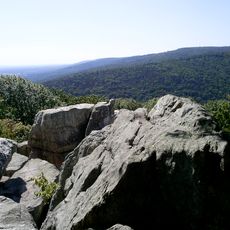
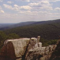
Pen Mar Park is a public park on South Mountain in Maryland, sitting at about 1,400 feet (430 m) above sea level with open views over the Cumberland Valley. The grounds include covered picnic shelters, playgrounds, and hiking trails that connect directly to the Appalachian Trail.

The Western Maryland Railroad established this site in 1877 as a resort destination, adding rides, theaters, and a dance pavilion to attract passengers to the mountain. It operated as an amusement park for decades before closing in 1943, after which the land became a public park.

Every summer, the park hosts outdoor concerts and community gatherings that draw people from across the region. The covered pavilions fill with families on weekends, making this mountain setting a natural meeting point for local life.

The park is easy to explore on foot, and the trails are clearly marked, making it simple to find your way around. Spring and fall tend to offer the most comfortable conditions on the mountain, so those seasons are a good time to visit.

One section of the park sits directly alongside an active rail line, where visitors can occasionally watch freight trains pass just a short distance away. This detail is a direct echo of the railroad that originally built the site more than a century ago.

The community of curious travelers

AroundUs brings together thousands of curated places, local tips, and hidden gems, enriched daily by 60,000 contributors worldwide.

Start exploring
Location
GPS coordinates
39.71690,-77.50810
Latest update
March 3, 2026 10:07
Around this place
Catoctin Mountain
United States of America

Catoctin Mountain

8.4 km
Quirauk Mountain
United States of America

Quirauk Mountain

2.3 km
Camp Misty Mount Historic District
United States of America

Camp Misty Mount Historic District

9.8 km
Camp Greentop Historic District
United States of America

Camp Greentop Historic District

8.5 km
Alexander Hamilton House
United States of America

Alexander Hamilton House

7.2 km
Victor Cullen Center, Old Administration Building
United States of America

Victor Cullen Center, Old Administration Building

4.4 km
Jacks Mountain Covered Bridge
United States of America

Jacks Mountain Covered Bridge

11.8 km
Welty's Mill Bridge
United States of America

Welty's Mill Bridge

6 km
Monterey Historic District
United States of America

Monterey Historic District

4 km
Borough Hall of the Borough of Waynesboro
United States of America

Borough Hall of the Borough of Waynesboro

7.2 km
Royer-Nicodemus House and Farm
United States of America

Royer-Nicodemus House and Farm

5.5 km
Victor Cullen School Power House
United States of America

Victor Cullen School Power House

4 km
Bell-Varner House
United States of America

Bell-Varner House

10.1 km
The Willows
United States of America

The Willows

12.9 km
Leitersburg Historic District
United States of America

Leitersburg Historic District

10 km
Jeremiah Burns Farm
United States of America

Jeremiah Burns Farm

5.8 km
Joseph J. Oller House
United States of America

Joseph J. Oller House

7.7 km
Lantz-Zeigler House
United States of America

Lantz-Zeigler House

11.6 km
Tipahato
United States of America

Tipahato

2.4 km
Handycraft Farmstead
United States of America

Handycraft Farmstead

5.7 km
Rockledge
United States of America

Rockledge

9.5 km
Good-Hartle Farm
United States of America

Good-Hartle Farm

11 km
Renfrew Museum and Park
United States of America

Renfrew Museum and Park

5.4 km
Catoctin Mountain Park Visitor Center
United States of America

Catoctin Mountain Park Visitor Center

10.5 km
Chimney Rock
United States of America

Chimney Rock

11.7 km
South Beach
United States of America

South Beach

10.7 km
Mt. Moriah Lutheran Church
United States of America

Mt. Moriah Lutheran Church

7.7 km
Catoctin Mountain Park Resource Management Office
United States of America

Catoctin Mountain Park Resource Management Office

8.2 km
Show the full map
Reviews
Share your experience

No review yet

Discussions
Start a discussion...

No discussion yet

« Pen Mar Park - Public park in Cascade, Maryland » is provided by Around Us (aroundus.com). Images and texts are derived from Wikimedia project under a Creative Commons license. You are allowed to copy, distribute, and modify copies of this page, under the conditions set by the license, as long as this note is clearly visible.

Discover hidden gems everywhere you go!

From secret cafés to breathtaking viewpoints, skip the crowded tourist spots and find places that match your style. Our app makes it easy with voice search, smart filtering, route optimization, and insider tips from travelers worldwide. Download now for the complete mobile experience.

Around Us App Screenshot

A unique approach to discovering new places

Le Figaro

All the places worth exploring

France Info

A tailor-made excursion in just a few clicks

20 Minutes

Around Us
Travel Guide & Maps
Download

Send to your phone

QR Code
1

Open the camera app on your mobile.

2

Point at the QR code with your camera. A notification will appear.

3

Tap the notification to open the link.