Enable Location

We need your location to show you interesting places around you

Discover nearby places

Find interesting locations and hidden gems around you

Precise directions

Get accurate directions and distances to places

Your location is never shared with other users. It's only used when you tap the location button.

Pharr Mounds

Log in to your account

Start exploring — it's free

Trusted by 61,868 travelers worldwide

Continue with Google
Continue with Apple
or

We will send you a code to connect

By continuing, you accept our Terms and Conditions and our Privacy Policy

Check your inbox

We've sent a pincode in your inbox. Please enter the code below.

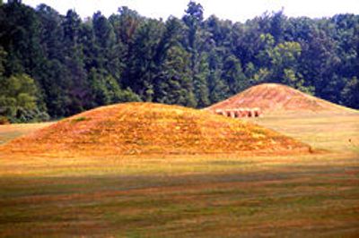
Pharr Mounds, Archaeological complex with eight burial mounds in northern Mississippi, United States.

Description

Pharr Mounds is an archaeological site in northern Mississippi containing eight dome-shaped burial mounds of varying sizes spread across 36 hectares (90 acres). The largest mound reaches about 61 meters (200 feet) in diameter and rises visibly above the surrounding landscape.

History

The mounds were built between 1 and 200 CE during the Miller culture period as burial grounds for mobile Native American groups. This era marks a significant phase of mound-building traditions in the region.

Culture

The site reveals trade connections between distant regions through copper, greenstone, and mica objects discovered during excavations. These items show that local communities maintained links with peoples living far away.

Practical

The site sits at mile marker 286.7 of the Natchez Trace Parkway, roughly 37 kilometers (23 miles) northeast of Tupelo. The grounds are open to visitors and feature educational information about the burial practices of ancient communities.

Did you know?

Four of the eight mounds contain fire pits and clay platforms at their base, where both cremated and non-cremated human remains were discovered. These variations in burial methods reveal the diversity of mortuary practices among these early peoples.

Location
Location
GPS coordinates
34.46649,-88.41671
Latest update
December 10, 2025 20:01

AroundUs brings together thousands of curated places, local tips, and hidden gems, enriched daily by 60,000 contributors worldwide. Discover all places nearby (Itawamba County).

Around this place
Elvis Presley Birthplace
United States of America

Elvis Presley Birthplace

33.4 km
Woodall Mountain
United States of America

Woodall Mountain

39.2 km
Natchez Trace Trail
United States of America

Natchez Trace Trail

37.5 km
Tishomingo State Park
United States of America

Tishomingo State Park

25.9 km
Tupelo Automobile Museum
United States of America

Tupelo Automobile Museum

34.6 km
Barton Hall
United States of America

Barton Hall

49.5 km
Bay Springs Lake
United States of America

Bay Springs Lake

14.9 km
Tupelo Buffalo Park and Zoo
United States of America

Tupelo Buffalo Park and Zoo

38.1 km
Trace State Park
United States of America

Trace State Park

50.1 km
Tombigbee State Park
United States of America

Tombigbee State Park

32 km
Jamie Whitten Lock and Dam
United States of America

Jamie Whitten Lock and Dam

10.5 km
Fairpark
United States of America

Fairpark

35 km
Veranda House
United States of America

Veranda House

53.2 km
Overton Farm
United States of America

Overton Farm

43.1 km
Fulton Lock
United States of America

Fulton Lock

23.2 km
Midtown Corinth Historic District
United States of America

Midtown Corinth Historic District

53.1 km
G. V. Montgomery Lock
United States of America

G. V. Montgomery Lock

4.8 km
Church of Our Saviour
United States of America

Church of Our Saviour

43.7 km
North Broadway Historic District
United States of America

North Broadway Historic District

35.1 km
First Methodist Church
United States of America

First Methodist Church

35.4 km
Downtown Corinth Historic District
United States of America

Downtown Corinth Historic District

52.9 km
Downtown Booneville Historic District
United States of America

Downtown Booneville Historic District

25 km
Amory's Tribute to the Heroes of 1861–1865
United States of America

Amory's Tribute to the Heroes of 1861–1865

54 km
Stewart-Anderson House
United States of America

Stewart-Anderson House

35.2 km
Red Bay Water Park
United States of America

Red Bay Water Park

25.3 km
Tammy Wynette Legacy Center
United States of America

Tammy Wynette Legacy Center

29.4 km
Amory Railway Bridge
United States of America

Amory Railway Bridge

52.8 km
Tishomingo State Park Historic District
United States of America

Tishomingo State Park Historic District

26.3 km
Show the full map
« Pharr Mounds - Archaeological complex with eight burial mounds in northern Mississippi, United States » is provided by Around Us (aroundus.com). Images and texts are derived from Wikimedia project under a Creative Commons license. You are allowed to copy, distribute, and modify copies of this page, under the conditions set by the license, as long as this note is clearly visible.

Discover hidden gems everywhere you go!

From secret cafés to breathtaking viewpoints, skip the crowded tourist spots and find places that match your style. Our app makes it easy with voice search, smart filtering, route optimization, and insider tips from travelers worldwide. Download now for the complete mobile experience.

Around Us App Screenshot

A unique approach to discovering new places

Le Figaro

All the places worth exploring

France Info

A tailor-made excursion in just a few clicks

20 Minutes

Around Us
Travel Guide & Maps
Download

Send to your phone

QR Code
1

Open the camera app on your mobile.

2

Point at the QR code with your camera. A notification will appear.

3

Tap the notification to open the link.