Enable Location

We need your location to show you interesting places around you

Discover nearby places

Find interesting locations and hidden gems around you

Precise directions

Get accurate directions and distances to places

Your location is never shared with other users. It's only used when you tap the location button.

Fulton Lock

Log in to your account

Start exploring — it's free

Trusted by 62,440 travelers worldwide

Continue with Google
Continue with Apple
or

We will send you a code to connect

By continuing, you accept our Terms and Conditions and our Privacy Policy

Check your inbox

We've sent a pincode in your inbox. Please enter the code below.

Fulton Lock

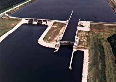
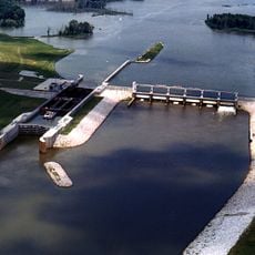
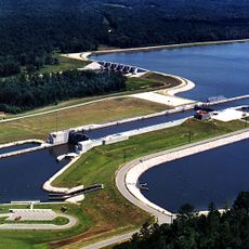
Fulton Lock, lock and dam on the Tennessee-Tombigbee Waterway in Itawamba County, Mississippi, United States

Fulton Lock is a navigation structure on the Tennessee-Tombigbee Waterway in Mississippi that raises or lowers vessels between different water levels. The structure stretches about 600 feet (180 meters) long and roughly 100 feet (30 meters) wide, allowing boats of various sizes to pass through safely.

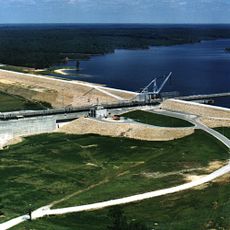
Fulton Lock was built in 1985 to enable safer navigation along the Tennessee-Tombigbee Waterway and support regional commerce. The project was a major infrastructure effort that connected the region with a functional water transportation system for freight and other vessels.

The lock stands as a visible reminder of how communities depend on engineering to manage water and maintain commerce. Its presence shapes how people in the area relate to the waterway, transforming it from a natural river into a working transportation corridor that serves daily regional life.

The lock is visible from U.S. Route 78, which crosses the waterway just south of the structure. Visitors can access nearby recreational areas and the Whitten Historical Center to learn about local history and the waterway's role in the region.

The lock operates like an elevator for vessels, raising or lowering them about 25 feet (7.5 meters) to match different water levels. Cargo ships and military vessels receive priority, while smaller pleasure boats have scheduled times in the morning and afternoon when they can pass through.

The community of curious travelers

AroundUs brings together thousands of curated places, local tips, and hidden gems, enriched daily by 60,000 contributors worldwide.

Start exploring
Location
GPS coordinates
34.25780,-88.42480
Latest update
February 9, 2026 11:07
Around this place
Elvis Presley Birthplace
United States of America

Elvis Presley Birthplace

23.5 km
Tishomingo State Park
United States of America

Tishomingo State Park

44.2 km
Tupelo Automobile Museum
United States of America

Tupelo Automobile Museum

25 km
Pharr Mounds
United States of America

Pharr Mounds

23.2 km
Bay Springs Lake
United States of America

Bay Springs Lake

36.3 km
James Greer Bankhead House
United States of America

James Greer Bankhead House

48.2 km
Trace State Park
United States of America

Trace State Park

43.7 km
Tombigbee State Park
United States of America

Tombigbee State Park

18.4 km
Jamie Whitten Lock and Dam
United States of America

Jamie Whitten Lock and Dam

30.8 km
Aberdeen Lock and Dam
United States of America

Aberdeen Lock and Dam

48.4 km
Reuben Davis House
United States of America

Reuben Davis House

49.6 km
Fairpark
United States of America

Fairpark

25.4 km
Overton Farm
United States of America

Overton Farm

45.2 km
G. V. Montgomery Lock
United States of America

G. V. Montgomery Lock

23.5 km
West Commerce Street Historic District
United States of America

West Commerce Street Historic District

49.6 km
Aberdeen City Hall
United States of America

Aberdeen City Hall

49.4 km
North Broadway Historic District
United States of America

North Broadway Historic District

25.8 km
First Methodist Church
United States of America

First Methodist Church

26 km
Downtown Booneville Historic District
United States of America

Downtown Booneville Historic District

46.1 km
John Holliday House
United States of America

John Holliday House

50.1 km
Amory's Tribute to the Heroes of 1861–1865
United States of America

Amory's Tribute to the Heroes of 1861–1865

30.9 km
Old Homestead
United States of America

Old Homestead

49.6 km
Stewart-Anderson House
United States of America

Stewart-Anderson House

26.2 km
Tammy Wynette Legacy Center
United States of America

Tammy Wynette Legacy Center

15.1 km
Aberdeen Downtown Historic District
United States of America

Aberdeen Downtown Historic District

49.3 km
Amory Railway Bridge
United States of America

Amory Railway Bridge

29.8 km
Downtown Tupelo Historic District
United States of America

Downtown Tupelo Historic District

26 km
Tishomingo State Park Historic District
United States of America

Tishomingo State Park Historic District

44.4 km
Show the full map
« Fulton Lock - lock and dam on the Tennessee-Tombigbee Waterway in Itawamba County, Mississippi, United States » is provided by Around Us (aroundus.com). Images and texts are derived from Wikimedia project under a Creative Commons license. You are allowed to copy, distribute, and modify copies of this page, under the conditions set by the license, as long as this note is clearly visible.

Discover hidden gems everywhere you go!

From secret cafés to breathtaking viewpoints, skip the crowded tourist spots and find places that match your style. Our app makes it easy with voice search, smart filtering, route optimization, and insider tips from travelers worldwide. Download now for the complete mobile experience.

Around Us App Screenshot

A unique approach to discovering new places

Le Figaro

All the places worth exploring

France Info

A tailor-made excursion in just a few clicks

20 Minutes

Around Us
Travel Guide & Maps
Download

Send to your phone

QR Code
1

Open the camera app on your mobile.

2

Point at the QR code with your camera. A notification will appear.

3

Tap the notification to open the link.