Enable Location

We need your location to show you interesting places around you

Discover nearby places

Find interesting locations and hidden gems around you

Precise directions

Get accurate directions and distances to places

Your location is never shared with other users. It's only used when you tap the location button.

Pixley Falls State Park

Log in to your account

Start exploring — it's free

Trusted by 61,867 travelers worldwide

Continue with Google
Continue with Apple
or

We will send you a code to connect

By continuing, you accept our Terms and Conditions and our Privacy Policy

Check your inbox

We've sent a pincode in your inbox. Please enter the code below.

Pixley Falls State Park

Pixley Falls State Park, Natural state park in Boonville, United States

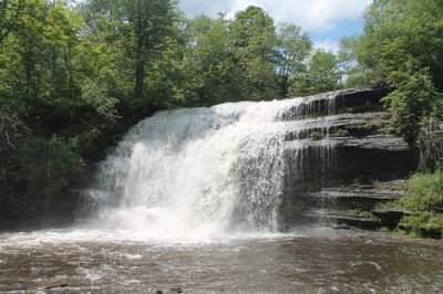
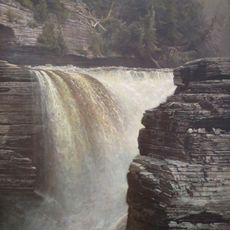
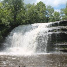
Pixley Falls State Park is a natural area featuring a waterfall dropping roughly 50 feet down steep wooded hillsides, along with cold-water streams that support native trout. The property spans about 375 acres and provides marked hiking routes through forested landscape.

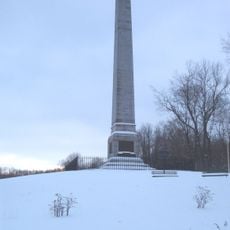
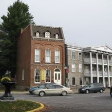
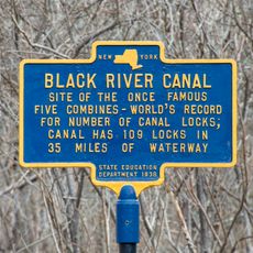
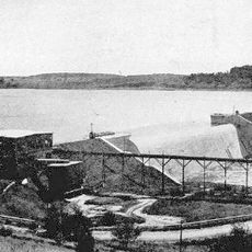
The park was established in 1924 and preserves remnants of the Black River Canal, a 19th-century waterway system that once served the region's transportation needs. This industrial past remains visible in the landscape, showing how the area functioned economically in earlier times.

The park serves as a place for outdoor activities that have been part of life in this region for generations, from fishing to winter sports depending on the season. This long tradition shapes how locals and visitors experience the space today.

The area is open year-round for hiking and offers a covered pavilion available for rental by small groups. Wear sturdy shoes since the trails go through steep sections and uneven terrain.

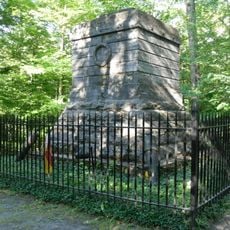
In some spots, old canal walls run alongside modern hiking trails, creating an unexpected mixing of past infrastructure and present use. These remnants are subtle and easy to miss, but for attentive visitors they offer an interesting hint at how the area has transformed.

The community of curious travelers

AroundUs brings together thousands of curated places, local tips, and hidden gems, enriched daily by 60,000 contributors worldwide.

Start exploring
Location
GPS coordinates
43.40000,-75.34000
Latest update
December 10, 2025 20:02
Around this place
Fort Stanwix
United States of America

Fort Stanwix

23.1 km
United States of America

Rome Laboratory

19.7 km
Oriskany Battlefield State Historic Site
United States of America

Oriskany Battlefield State Historic Site

24.9 km
Steuben Memorial State Historic Site
United States of America

Steuben Memorial State Historic Site

11.1 km
Delta Lake
United States of America

Delta Lake

14.6 km
Delta Lake State Park
United States of America

Delta Lake State Park

13.8 km
Trenton Falls
United States of America

Trenton Falls

20.1 km
Gen. William Floyd House
United States of America

Gen. William Floyd House

11 km
Edmund Wilson House
United States of America

Edmund Wilson House

15.1 km
Gould Mansion Complex
United States of America

Gould Mansion Complex

24.3 km
Rome Arsenal
United States of America

Rome Arsenal

23 km
United States of America

Zion Church

22.9 km
Jervis Public Library
United States of America

Jervis Public Library

22.2 km
Constable Hall
United States of America

Constable Hall

19.2 km
Pixley Falls
United States of America

Pixley Falls

418 m
Jonathan C. Collins House and Cemetery
United States of America

Jonathan C. Collins House and Cemetery

19.9 km
Gansevoort-Bellamy Historic District
United States of America

Gansevoort-Bellamy Historic District

22.8 km
Constableville Village Historic District
United States of America

Constableville Village Historic District

19.7 km
Holland Patent Stone Churches Historic District
United States of America

Holland Patent Stone Churches Historic District

18.9 km
Mills House (Rome, New York)
United States of America

Mills House (Rome, New York)

22.4 km
Boonville Historic District
United States of America

Boonville Historic District

9.4 km
Five Lock Combine and Locks 37 and 38, Black River Canal
United States of America

Five Lock Combine and Locks 37 and 38, Black River Canal

1.9 km
Ava Town Hall
United States of America

Ava Town Hall

11.5 km
Western Town Hall
United States of America

Western Town Hall

10.8 km
First Methodist Episcopal Church of Rome
United States of America

First Methodist Episcopal Church of Rome

22.6 km
Erwin Library and Pratt House
United States of America

Erwin Library and Pratt House

9.3 km
Mappa Hall
United States of America

Mappa Hall

18.7 km
Hinckley Reservoir
United States of America

Hinckley Reservoir

21.2 km
Show the full map
« Pixley Falls State Park - Natural state park in Boonville, United States » is provided by Around Us (aroundus.com). Images and texts are derived from Wikimedia project under a Creative Commons license. You are allowed to copy, distribute, and modify copies of this page, under the conditions set by the license, as long as this note is clearly visible.

Discover hidden gems everywhere you go!

From secret cafés to breathtaking viewpoints, skip the crowded tourist spots and find places that match your style. Our app makes it easy with voice search, smart filtering, route optimization, and insider tips from travelers worldwide. Download now for the complete mobile experience.

Around Us App Screenshot

A unique approach to discovering new places

Le Figaro

All the places worth exploring

France Info

A tailor-made excursion in just a few clicks

20 Minutes

Around Us
Travel Guide & Maps
Download

Send to your phone

QR Code
1

Open the camera app on your mobile.

2

Point at the QR code with your camera. A notification will appear.

3

Tap the notification to open the link.