Enable Location

We need your location to show you interesting places around you

Discover nearby places

Find interesting locations and hidden gems around you

Precise directions

Get accurate directions and distances to places

Your location is never shared with other users. It's only used when you tap the location button.

Trenton Falls

Log in to your account

Start exploring — it's free

Trusted by 61,867 travelers worldwide

Continue with Google
Continue with Apple
or

We will send you a code to connect

By continuing, you accept our Terms and Conditions and our Privacy Policy

Check your inbox

We've sent a pincode in your inbox. Please enter the code below.

Trenton Falls

Trenton Falls, Natural waterfall system in Trenton, United States.

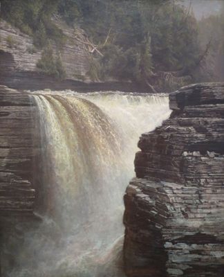
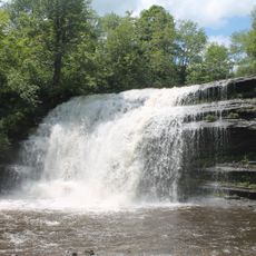
Trenton Falls is a waterfall system featuring multiple cascades along West Canada Creek that descends through limestone formations. The total vertical drop spans roughly 270 feet, creating a series of steps as the water moves through the gorge.

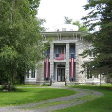
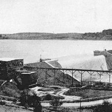
John Sherman discovered these falls in 1805, leading to the development of a resort property in the area. The property attracted visitors through the early 1900s and played an important role in the local tourism of that era.

The Haudenosaunee named this location Ka-na-ta-dork, meaning brown water, and Kuy-a-ho-ra, referring to the slanting water formations. These names reflect how the indigenous people identified and described the distinctive features they observed here.

The site opens to the public only during two weekends per year, with stone dust paths and wood mulch walkways along the gorge edges. Visitors should wear sturdy footwear and prepare for uneven surfaces and narrow pathways.

The limestone walls contain numerous marine fossils, including Concularia, echinoderms, cephalopods, gastropods, and preserved ancient bryozoans. These findings offer a glimpse into the ancient sea that covered this region millions of years ago.

The community of curious travelers

AroundUs brings together thousands of curated places, local tips, and hidden gems, enriched daily by 60,000 contributors worldwide.

Start exploring
Location
Part of
West Canada Creek
GPS coordinates
43.28150,-75.15310
Latest update
December 12, 2025 14:27
Around this place
Oriskany Battlefield State Historic Site
United States of America

Oriskany Battlefield State Historic Site

21 km
Steuben Memorial State Historic Site
United States of America

Steuben Memorial State Historic Site

9 km
Pixley Falls State Park
United States of America

Pixley Falls State Park

20.1 km
Gen. William Floyd House
United States of America

Gen. William Floyd House

18.9 km
Grace Church
United States of America

Grace Church

21.1 km
Yale-Cady Octagon House and Yale Lock Factory Site
United States of America

Yale-Cady Octagon House and Yale Lock Factory Site

14.7 km
Fort Schuyler Club Building
United States of America

Fort Schuyler Club Building

21.3 km
Doyle Hardware Building
United States of America

Doyle Hardware Building

20.6 km
Alexander Pirnie Federal Building
United States of America

Alexander Pirnie Federal Building

20.7 km
New Century Club
United States of America

New Century Club

21.3 km
Byington Mill
United States of America

Byington Mill

20.7 km
Gen. John G. Weaver House
United States of America

Gen. John G. Weaver House

19.1 km
Cold Brook Feed Mill
United States of America

Cold Brook Feed Mill

10.2 km
Utica Daily Press Building
United States of America

Utica Daily Press Building

20.6 km
Newport Stone Arch Bridge
United States of America

Newport Stone Arch Bridge

15.4 km
Pixley Falls
United States of America

Pixley Falls

20.5 km
Benjamin Bowen House
United States of America

Benjamin Bowen House

13.2 km
Hurd & Fitzgerald Building
United States of America

Hurd & Fitzgerald Building

20.6 km
Holland Patent Stone Churches Historic District
United States of America

Holland Patent Stone Churches Historic District

9.6 km
East Main Street Historic District
United States of America

East Main Street Historic District

21 km
Russia Corners Historic District
United States of America

Russia Corners Historic District

6.5 km
Norway Baptist Church
United States of America

Norway Baptist Church

18.2 km
Whitestown Town Hall
United States of America

Whitestown Town Hall

21.1 km
Western Town Hall
United States of America

Western Town Hall

18.7 km
Masonic Temple — Newport Lodge No. 445 F. & A.M.
United States of America

Masonic Temple — Newport Lodge No. 445 F. & A.M.

16.1 km
Mappa Hall
United States of America

Mappa Hall

3.1 km
Lower Genesee Street Historic District
United States of America

Lower Genesee Street Historic District

20.7 km
Hinckley Reservoir
United States of America

Hinckley Reservoir

4.9 km
Show the full map
« Trenton Falls - Natural waterfall system in Trenton, United States » is provided by Around Us (aroundus.com). Images and texts are derived from Wikimedia project under a Creative Commons license. You are allowed to copy, distribute, and modify copies of this page, under the conditions set by the license, as long as this note is clearly visible.

Discover hidden gems everywhere you go!

From secret cafés to breathtaking viewpoints, skip the crowded tourist spots and find places that match your style. Our app makes it easy with voice search, smart filtering, route optimization, and insider tips from travelers worldwide. Download now for the complete mobile experience.

Around Us App Screenshot

A unique approach to discovering new places

Le Figaro

All the places worth exploring

France Info

A tailor-made excursion in just a few clicks

20 Minutes

Around Us
Travel Guide & Maps
Download

Send to your phone

QR Code
1

Open the camera app on your mobile.

2

Point at the QR code with your camera. A notification will appear.

3

Tap the notification to open the link.